- For other places with the same name, see Berneray (disambiguation).
Berneray is an island in the Outer Hebrides or Western Isles of Scotland. It's about three miles north-south by two miles east-west, mostly low-lying, and is joined to the larger island of North Uist by road. In 2011 the population was 138.
In Old Norse Bjarnar-øy means "Bjorn's island" - several islands have similar names, probably because Bjorn was a common personal name rather than referring to a single mighty landowner. This island is distinguished in English as "Berneray - North Uist" and in Gaelic as Beàrnaraigh na Hearadh, Berneray of Harris.
Understand
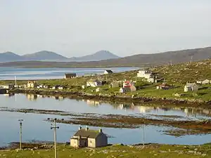
Berneray is by no means remote, but until late in the 20th century it was difficult to reach. You needed to take three ferries, from mainland to Skye to North Uist to Berneray, and tourists had little reason to bother. That changed dramatically in 1999 when the road causeway linked it to North Uist, and the ferry service for Harris relocated here from Lochmaddy. This means that Berneray nowadays has thousands of visitors who only see 200 yards of it, between the pier and the causeway. It also made the island a lynchpin in the connectivity of the entire Western Isles, as the once or twice a week Harris ferry became a shorter crossing three times a day. But beyond that thoroughfare, the rest of Berneray is a back-eddy with a quiet rural way of life.
The bedrock of the Outer Hebrides is gneiss laid down three billion years ago, very hard and impermeable. On North Uist just south this lies flat and is overlain by bog and dozens of small lochans, and on Harris just east it's heaped up into gnarly hills; both are a dismal prospect for farming. Berneray is something of a "Goldilocks zone" between them, with better-drained sandy "machair" terrain to the west, and to the east a straggle of habitation sheltered by low hills. Ardmaree, Backhill (the largest, with the fishing harbour), Rushgarry and Sandhill, with Borve more central, all merge into each other.
All these islands were inhabited from prehistoric times, then by Celts and Vikings. Folk lived by crofting - subsistence farming and fishing - in a way that persisted here right up to the 1850s. Distant lords fought for control but there were no battles or castles on Berneray. The big change came with the potato famine of the 1840s followed by the Clearances, when much of the population was evicted to make way for sheep grazing. People made a partial return in the 20th century as landlords were more sympathetic to crofting. But even in the 1980s, Berneray was sufficiently secluded that Princes Charles (now King Charles III) could spend a week here training in crofting without the world noticing and a swarm of media alighting.
Summer (June-Aug) is the best time to visit, with long warm (well, sort of warm) days, and the machair terrain means fewer pesky midges than on the other boggy islands. Spring and autumn bring migratory bird species. In winter the community draws in on itself, but visitors are the more welcome for being few. It can be wet and windy any time, the rain pelting as if to challenge first your cagoul then the underlying gneiss; then the clouds roll away into purple masses over Harris and the sun strikes through. The mist off the damp fields mingles with the collective dreaming of seals hauled out on the beach.
Get in
By plane
🌍 Benbecula (BEB IATA) is the airport for the Uists, 25 miles south across the causeways. Loganair fly daily from Glasgow taking an hour, and fly M-F from Stornoway on Lewis taking 35 min. The buses from South Uist run past the airport, taking an hour.
Alternative airports are Stornoway (SYY IATA) and Barra (BRR IATA). Reaching either involves a ferry crossing and a long drive.
By boat
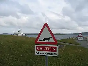
🌍 Berneray ferry pier is the landing point for Calmac ferries from Leverburgh on Harris, taking an hour. April-Oct there are 4 M-Sa and 3 Su, Nov-March 2 or 3 a day, see Leverburgh#Get in for fares. The pier is an unattended slipway with a small waiting room with toilets; there are no shops or other facilities here. The ferry berths overnight alongside the causeway: there is no sea passage through this, unless you're a fish or an otter and can swim through the culverts.
Ferries also sail from Uig on Skye to Lochmaddy on North Uist, 11 miles by connecting bus from Berneray. This ferry is suspended 30 Oct - 11 Dec 2023 for harbour works at Uig.
🌍 Berneray harbour is the landing point for yachts and other small craft, which should keep clear of the ferry pier. There's a toilet and shower block, moorings, and a lifting crane. Bays Loch the inlet is shallow and has limited shelter, in rough weather (especially from the north) make for Lochmaddy on North Uist.
By road
The causeway from North Uist (B893) is passable at all tides and in all but the worst Atlantic weather. Causeway and approach roads are double tracked, a luxury in these islands, but beyond that the roads are the standard Hebridean single-track lane with passing places.
Buses run regularly from South and North Uist to the ferry pier, and from Stornoway and Tarbert to Leverburgh ferry pier. Bus W10 / 16 / 17 runs M-Sa along the chain of islands so you can travel in a day between Stornoway on Lewis and Castlebay on Barra. Only one service per day plies the entire route, but Berneray being midway has more connections, with four buses from Stornoway, six from Tarbert on Harris, six from North Uist, Benbecula and South Uist, and three from Barra.
Get around
Walking will get you everywhere on this compact island. A single-track paved lane follows the east coast, with another through the centre and a third across the southside machair.
A waymarked path circles the island, or you can simply follow the shoreline along the long beaches - a complete circuit might take five hours. As elsewhere, dress for the changeable weather and have stout footwear.
There's no car hire on Berneray nor on North Uist, see Benbecula for firms based at the airport.
Talk
Gaelic is the first language of over half the population, and is given precedence on road signs. It will boost your welcome to know a few common words and phrases. English is universally spoken, with a distinct lilt and Gaelic pronunciation.
See

- 🌍 Beinn a'Chlaidh (Hill of the Graveyard) is a ritual area in the south, though it's unclear what is prehistoric and what is Viking / early Medieval or later. There's a standing stone (Clach Mhor, big stone), west of it the remnants of a Bronze Age chambered cairn (A'Chiste Chloiche, the stone chest), and 125 yards southwest is Leac an Righ (stone of the king). This is carved with the imprint of a human foot and resembles the stone at Dunadd in mainland Argyll where kings of Dál Riata were crowned.
- Nurse's Cottage 200 yards north of the harbour is the base for Berneray Historical Society (Chomunn Eachdraidh Bheàrnaraigh). It's open May-Aug M-F 11:00-15:00 and has a small exhibition of island life. The society publishes an online newsletter in May and Nov each year. A resident nurse wasn't needed once the causeway offered help from the other Uists.
- 🌍 Berneray Church, Church Road HS6 5BD. The church is a plain 19th century building above Backhill the main settlement. It's Presbyterian (C of S) but all are welcome at services, held at noon on the 1st, 3rd and 5th Sunday of each month, with the 2nd and 4th Sunday services in Lochmaddy. These are mostly in English, with one psalm in Gaelic. Psalms are sung in the Hebridean style with no music.
- Grey seals or Atlantic seals (Halichoerus grypus) have a colony on the shore of Bays Loch, and an even larger on the west coast where they're less disturbed. They're the ones with broad Roman noses, while Common or Harbour seals (Phoca vitulina), also found here, have puppy-dog noses.
- Otters (Lutra lutra) are most likely to be seen on the rocky east and south coasts, and Bays Loch is as good a place as any. Freshwater springs flow out on those coasts, which otters need to clean their coats, and the crabs they eat dwell among the rocks. The rising tide gets the crabs busy so the otters do likewise.
- Crotal is the orange lichen on the intertidal rocks. From it is extracted a red dye used in traditional knitwear, but first the wool thread must be cleansed of its oils and soaked in a "mordant" so the dye will fix and not wash out. England from the Middle Ages used Fuller's Earth for this, but Highland Scotland up to the Clearances still used the age-old mordant of urine, human or animal, the staler and stinkier the better for its ammonia content. Hand-working the wee into the fabric was communal women's work, accompanied by "waulking songs".
- The Armoury of Macleod 50 yards north of the Youth Hostel is more prosaically a ruined 18th century cow shed. A Latin plaque above the door states that this was birthplace of Sir Norman MacLeod, who fought at the Battle of Worcester in 1651. There's no sign of a structure that old, perhaps it was built over or its stone re-used to house the cows.
- Port Ludaig next to the Youth Hostel is the stumps of an old jetty, probably from Sir Norman's times when Ruisigearraidh (Rushgarry) was a sizable farming community and transport along the island tracks was onerous. A shingle bank stretches out for a mile at low tide, with an inshore cut-through navigable by small craft.
- 🌍 Telford Kirk or Parliamentary Church fell into ruin but has been rebuilt as a private house. Early 19th century church provision was out of kilter with population centres, so government money was allocated to build "Commissioners Churches" across England. In 1824 this was begrudgingly extended to Scotland, with the entire country receiving less than was spent on a single English church. Thomas Telford built 30-some to a simple austere design on which every expense was scrimped, including this example at Rushgarry.
- East Beach is the long sandy stretch by the Telford Kirk. It's a convenient picnic spot as it's flanked by a public road.
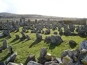
- 🌍 Old Berneray Cemetery is a walled enclosure on the south flank of Ben Leva. It's disused and the graves are mostly 19th century. Earlier grave markers are badly eroded and it's possible some of them are just stones, dumped here to clear the farmland.
- Cill Aiseam, the church of St Asaph (a 6th-century Welsh bishop) lay in a green spot on the hill midway between the old cemetery and Cnoc Na Greine. Ruins were still visible in the Victorian era but now all trace has vanished.
- Lazybeds (Gaelic feannagan) are the cause of the parallel furrows seen in hillside fields. This cultivation system maybe got its name because the field surface lay untilled and idle, while ridges were heaped up with peat and seaweed fertiliser. It was the common way to grow potatoes in 18th / 19th century Ireland and Highland Scotland, and demanded no small labour, but the name gave gentry the notion that their tenants were layabouts smoking their clay pipes and procreating far too many children. The system mostly died out during the 1840s blight and famines, as did those whose survival depended on home-grown potatoes.
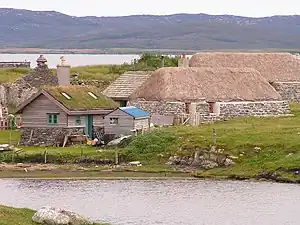
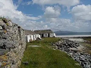
- Blackhouses are seen all around the island, many in ruins, others deserted but several restored, such as the Youth Hostel. They had double dry-stone walls packed with earth, and wooden rafters covered with a turf or thatch roof. If thatch, it would be pinned down by a "hairnet" weighted with stones against the winter gales. The floor was flagstones or packed earth, with a fire in the central hearth which must never be allowed to go out. No chimney, so the smoke percolated through the roof and stained the residents. That helped distract from the stench from the cattle that also lived within, separated by a wooden partition. After the 1850s, people upgraded to more hygienic taighean geala, white houses, and it only remained to take down their blackhouse partition to turn the whole smelly abode into a byre.
- 🌍 Cnoc Na Greine (Hillock of the Sun) is a grouping of stones, mostly likely a burial chamber. The largest is a glacial erratic boulder, naturally deposited there, then three other stones were positioned as chamber supports. Human remains were found here but are undated.
- 🌍 Loch Bhrusda is a freshwater lake with fishing for brown trout, and the island's water supply. You might see mute swans, greylag geese and buzzards, better known as "tourist eagles" - if a visitor spots an eagle, it's probably a buzzard. The loch gives its name to the ferry that initially plied the Berneray-Harris route, but it only had room for 18 cars and soon had to be replaced. MV Loch Bhrusda now acts as a back-up vessel whenever a Calmac ferry is out of action, which in the 2020s is all too common.
- 🌍 Chairstones are a group west of the lane end at Borve, part of a prehistoric burial chamber. Some 20 yards south, one stone happens to resemble a chair facing the others, so this gave rise to the legend that it was a Viking law court.
- West beach runs the length of the Atlantic coast and is backed by machair coarse grass and sand dunes. Wading birds on the shore include redshanks, sanderlings, turnstones, oyster catchers, dunlin, curlews, whimbrels, ringed plovers and herons; further out you see gannets diving.
- 🌍 Giant MacAskill Monument, Queen's Beach. A drystone plinth marks the birthplace of Angus MacAskill (1825–1863), the world's largest "true" giant. You can still discern the outline of the lost village of Sheabie - his family moved to Stornoway, and Sheabie was abandoned during the Clearances of the 1850s. Macaskill was six, and still a normal size, when they emigrated to Englishtown on Cape Breton Island. There in adolescence he grew and grew and grew to 7 ft 9 in / 2.36 m. His family were of unremarkable size, and he was a "true" giant with no hormonal or other metabolic syndrome, and of normal proportions. He was prodigiously strong and joined Barnum's circus as a performing strongman, then returned to Englishtown to own a mill and general store. Aged 38, he died of a "brain fever". There's a museum about him near Englishtown and another at Dunvegan on Skye. Several places in Scotland are called "Giant's Grave" and are prehistoric burial chambers, but this fellow was real.
- 🌍 Cnoc nan Claigeann ("Hill of the Skulls") hasn't been excavated, but findings include prehistoric pot shards and a mix of animal and human bones. It's probably that archaeologists' idea of paradise, a midden. A ruined shepherd's bothy stands on top, and nearby is the outline of a former blackhouse.
- Braighe na Ceilp (Breastwork of the Kelp) is at the end of West Beach, beyond the Hill of the Skulls. It's a grid of flat stones where kelp was dried before burning for potash. This was a lucrative industry in the early 19th century, as potash was essential to make soap, bleach, fertilisers and other chemicals. The price collapsed in 1822 when peace with France made cheaper imports available, and other chemical processes were devised. Kelp harvesting continued on a small scale for local use, but sharp fellows in top hats and high cravats no longer jostled to buy the stuff.
- 🌍 Pabbay is an uninhabited island three miles northwest of Berneray and about the same size. Its southeast is low-lying and fertile, with a landing beach though no harbour, but the population was evicted in 1846. It's been used ever since for sheep grazing and there's a modern farm building. Papey in Norse means hermit monks but there's scant trace of them here - the other Pabbay south of Barra has a ruined chapel.
- Shillay (Siolaigh) a mile north of Pabbay is triangular, half-a-mile each side. It's rugged and has never been permanently inhabited. The name means "seal island".
Do
- Water sports such as surfing and kayaking need to be self-organized, there isn't a business.
- Boat trips might be negotiable at the harbour, there's no schedule.
- Hills on Berneray take most of 15 minutes to walk up - the highest is Beinn Shleibhe at 93 m / 305 ft - but open out great views.
- Hebridean Way is a way-marked hiking and cycling trail the length of the Outer Hebrides. Stage 7 northbound simply follows the causeway from North Uist to the ferry pier and doesn't explore Berneray, but you can go further if your schedule allows.
- Report a rat: IAVs are the shorthand for Invasive Alien Vertebrates, beasts you don't want on an island. Rats are the worst, devouring the eggs and chicks of ground-nesting birds, which are otherwise well-adapted to the treeless Hebrides. Berneray is believed to be rat-free so if you see one report it, don't try to whack it yourself. Rabbits are almost as bad, and were supposedly absent but have been detected on the west coast. Neighbouring North Uist is overrun with them, and the causeway was fitted with deterrents, but they may have hoppity-hopped across.
- Trace your ancestors: Hebridean Connections is the online resource for historical material across the Western Isles, supplemented by national registries for births, marriages and deaths from 1841, and individual household Census records 1841-1921.
- Ceilidhs ("KAY-lee", traditional Scots music and dancing) are held frequently in the community hall. Enquire at the shop, which as the prime source of alcohol on Berneray will be well-informed. Similarly, the Christmas meal in the hall is open to residents and visitors.
- Dark skies: the island has little artificial lighting, so in winter you can easily find wide-open night skies, weather permitting, with a view of the stars and sometimes the aurora. This is a lost cause in summer when the sky never gets fully dark.
- Berneray Week is the third week in July, with sporting, cultural and festive events.
Buy
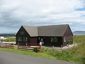
- No fuel and no ATM on Berneray - the nearest is Lochmaddy.
- 🌍 Berneray Shop, Borve, ☏ +44 1876 540288. M-Sa May-Sept 09:00-21:00, Oct-April 09:00-17:30. Stocks a large selection of packaged food and fresh local produce, plus alcohol, maps, books, outdoor clothing and hardware. See below for the bistro. The place has been painted white since the photo, but that doesn't mean the former black version housed cattle.
- 🌍 Coralbox, 3 Backhill HS6 5BD (at harbour), ☏ +44 7826 097599, coral-box@hotmail.com. Tu–Sa 10:30–17:00. A small gift shop in a harbourside wooden cabin, well-stocked with local wares.
- 🌍 Berneray Post Office, Backhill HS6 5BD (50 yards east of church), ☏ +44 1876 540249. M Tu Th F 09:30–13:00. This offers the standard postal services.
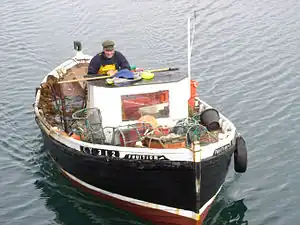
- Home produce such as eggs and vegetables are sometimes on sale at farm gates, with a roadside honesty box. You may be able to buy fresh catch when the fishing boats return to harbour, which depends on the tide. Now think about how you're going to boil that lobster with only a camp stove.
- RBS Mobile Bank. Tu 12:00-12:30. A Royal Bank of Scotland van visits the island on Tuesday at noon as part of a circuit of the Uists. Its days are probably numbered - Bank of Scotland have already withdrawn, and the big banks are under the impression that if islanders want a mobile banking service, all they need do is download an app.
Eat
- Berneray Bistro, Borve HS6 5BJ (within Berneray Shop), ☏ +44 1876 540288. Apr-Sep M–Sa 10:00–16:00, 18:00-20:30. Serves sandwiches, soups, wraps and cakes during the day, and 3 course dinners in the evening. Often busy, booking recommended for evening meals, they do takeaway. Friday evenings are fish & chips and Saturday evenings are pizza.
Drink
There are no pubs or hotel bars on Berneray, but the shop sells beer, wine and spirits.
Connect
As of Sept 2023, Berneray has 4G from EE but no reliable signal from other carriers, though you might get lucky by gaining height. 5G has not reached the Uists. Limited Wi-Fi is available in the ferry waiting room.
Berneray harbour has a coin-operated phone box, which BT are itching to scrap. Ofcom say they may not remove such remote boxes where the mobile coverage is poor and traditional landlines may be a lifesaver. So BT are biding their time until 2025, when the entire UK landline system is expected to be decommissioned.
Sleep
- Camping: there is no campsite on Berneray. Walkers and cyclists may wild-camp on the west coast, but you may not park a vehicle overnight. As of 2023, campers and motorhomes can pitch near the East Beach, where there is a £10 charge for camping on the croft land. Overnight parking is prohibited elsewhere.
- 🌍 Berneray Youth Hostel, 9 Rushgarry HS6 5BQ. Perched on the northeast coast with gorgeous views, the hostel is in two thatched white-harled "black houses". Open all year, it has a 6, 7 and 8 bed dorm, no private rooms, assistance dogs only. It's run by the Gatliff Trust, who also run Howmore hostel on South Uist and Rhenigidale on Harris. Like the others it has no phone and no booking, you turn up and take your chance. No camping hereabouts or parking campervans. Dorm adult £20, under-18 £10.
- 🌍 John's Bunkhouse, Ferry Croft, 23 Borve, ☏ +44 1876 540229. Clean friendly bunkhouse in a refurbished blackhouse, though with a modern roof not traditional "netted" thatch. No pets. Bunk adult £30, child £15.
- 🌍 Seal View B&B, 16 Backhill, Berneray HS6 5BD, ☏ +44 1876 540209, andrew@sealview.com. A well-named guest-house, as seals cavort on the shore in front. Open all year, it has a double room and a family room sleeping four, both en suite. Children and pets welcome. B&B double £110.
- 30 Backhill (red-door cottage 100 yards south of Seal View), ☏ +44 1588 660154. Rebuilt thatched blackhouse next to the sea, sleeps 3, booking Friday to Friday. £560-£730 per week.
- 🌍 The Smiddy, Burnside Croft, Borve HS6 5BJ, ☏ +44 1876 540235. Small cottage in a former blacksmith's workshop, sleeps 2, booking Sa-Sa. Well equipped with kitchen, jacuzzi, Wi-Fi and TV. £680-£905 per week.
- Laimraig Thatched Cottage by the Youth Hostel only rents by the month.
Go next
- The ferry to Leverburgh lands you in the rugged terrain of Harris. A road crosses the hills north to Lewis.
- Cross the causeway to North Uist, dotted with small lochs for fishing.
- The ferry from Lochmaddy on North Uist sails to Uig in the most scenic part of Skye.
- The chain of islands continues south through Benbecula, South Uist and Eriskay, where the ferry sails to Barra.