Woodruff (CDP), Wisconsin
Woodruff is a census-designated place in the Town of Woodruff in Oneida County, Wisconsin, United States.
Woodruff, Wisconsin | |
|---|---|
Census-designated place | |
 Downtown Woodruff | |
 Woodruff, Wisconsin | |
| Coordinates: 45°53′47″N 89°41′57″W | |
| Country | United States |
| State | Wisconsin |
| County | Oneida |
| Area | |
| • Total | 1.434 sq mi (3.71 km2) |
| • Land | 1.409 sq mi (3.65 km2) |
| • Water | 0.025 sq mi (0.06 km2) |
| Elevation | 1,608 ft (490 m) |
| Population (2010) | |
| • Total | 966 |
| • Density | 670/sq mi (260/km2) |
| Time zone | UTC-6 (Central (CST)) |
| • Summer (DST) | UTC-5 (CDT) |
| ZIP code | 54568 |
| Area code(s) | 715 & 534 |
| GNIS feature ID | 1577018[1] |

Woodruff sign on U.S. Route 51 / Wisconsin Highway 70
Description
Woodruff is located at the junction of U.S. Route 51, Wisconsin Highway 70, and Wisconsin Highway 47 22.5 miles (36.2 km) northwest of Rhinelander. Woodruff has a post office with ZIP code 54568.[2] As of the 2010 census, its population is 966.[3] Woodruff has a hospital, the Howard Young Medical Center.
References
- U.S. Geological Survey Geographic Names Information System: Woodruff
- ZIP Code Lookup
- "U.S. Census website". U.S. Census Bureau. Retrieved April 20, 2011.
External links
![]() Media related to Woodruff (CDP), Wisconsin at Wikimedia Commons
Media related to Woodruff (CDP), Wisconsin at Wikimedia Commons
Municipalities and communities of Oneida County, Wisconsin, United States | ||
|---|---|---|
| City | 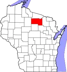 | |
| Towns | ||
| CDPs | ||
| Other communities | ||
| Ghost town | ||
| Footnotes | ‡This populated place also has portions in an adjacent county or counties | |
This article is issued from Wikipedia. The text is licensed under Creative Commons - Attribution - Sharealike. Additional terms may apply for the media files.