Windwardside
Windwardside is the second largest town on the island of Saba,[2] aptly named for being on the windward side of the island.
Windwardside | |
|---|---|
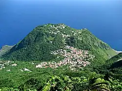 Windwardside as seen from Mount Scenery | |
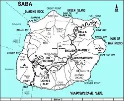 Map of Saba showing Windwardside | |
| Coordinates: 17°37′44.12″N 63°13′53.49″W | |
| Country | |
| Public body | |
| Elevation | 400 m (1,300 ft) |
| Population (2001)[1] | |
| • Total | 418 |
| Time zone | UTC-4 (AST) |
| Climate | Aw |
Geography
The hike up the stairs to the top of Mount Scenery can begin from the road just outside Windwardside.
Tourism
Two banks and several dive shops as well as grocery stores, gift shops, etc. are located here. There is also a maritime museum full of Saban history. Windwardside village also has several hotels and inns which serve mostly tourists who come to the island to dive and enjoy the Saban nature.[2] In 1860, the St. Paul's Conversion Church, Saba was built on the grounds of the former quarantine station.[3]
Gallery
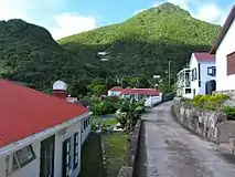 A central street
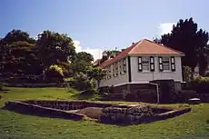 Harry L. Johnson Museum
See also
References
- "Geodata 2001, Saba & Sint.Eustatius, Census 2001". Centraal Bureau voor de Statistiek, Netherlands Antilles. 2001. p. 17. Retrieved 3 May 2021.
- The villages of Saba (Saba Tourist Bureau)
- "The Church of Rome on Saba". The Saba Islander. Retrieved 5 May 2021.
External links
![]() Media related to Windwardside at Wikimedia Commons
Media related to Windwardside at Wikimedia Commons
| Populated places | |||
|---|---|---|---|
| Other locations | |||
| Transport | |||
| Education | |||
| Heraldry | |||
| Culture | |||
This article is issued from Wikipedia. The text is licensed under Creative Commons - Attribution - Sharealike. Additional terms may apply for the media files.