Wildewood, Maryland
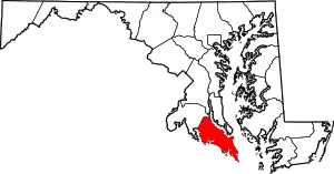
Wildewood is a planned community and census-designated place (CDP) in St. Mary's County, Maryland, United States. It is in east-central St. Mary's County, 7 miles (11 km) east of Leonardtown, the county seat, and 58 miles (93 km) southeast of Washington, D.C. It is bordered to the east by the unincorporated community of California.
Wildewood, Maryland | |
|---|---|
 Wildewood  Wildewood | |
| Coordinates: 38°18′11″N 76°32′47″W | |
| Country | |
| State | Maryland |
| County | St. Mary's |
| Area | |
| • Total | 2.93 sq mi (7.58 km2) |
| • Land | 2.83 sq mi (7.32 km2) |
| • Water | 0.10 sq mi (0.26 km2) |
| Elevation | 105 ft (32 m) |
| Population (2020) | |
| • Total | 7,821 |
| • Density | 2,767.52/sq mi (1,068.46/km2) |
| Time zone | UTC-5 (Eastern (EST)) |
| • Summer (DST) | UTC-4 (EDT) |
| ZIP Codes | |
| Area code(s) | 301, 240 |
| FIPS code | 24-84784 |
| GNIS feature ID | 2806311[2] |
Wildewood was first listed as a CDP prior to the 2020 census[2] which listed a population of 7,821.[3]
Demographics
| Census | Pop. | Note | %± |
|---|---|---|---|
| 2020 | 7,821 | — | |
| U.S. Decennial Census[4] 2020[5] | |||
2020 census
| Race / Ethnicity | Pop 2020[5] | % 2020 |
|---|---|---|
| White alone (NH) | 5,579 | 71.33% |
| Black or African American alone (NH) | 703 | 8.99% |
| Native American or Alaska Native alone (NH) | 17 | 0.22% |
| Asian alone (NH) | 456 | 5.83% |
| Pacific Islander alone (NH) | 6 | 0.08% |
| Some Other Race alone (NH) | 43 | 0.55% |
| Mixed Race/Multi-Racial (NH) | 482 | 6.16% |
| Hispanic or Latino (any race) | 535 | 6.84% |
| Total | 7,821 | 100.00% |
Note: the US Census treats Hispanic/Latino as an ethnic category. This table excludes Latinos from the racial categories and assigns them to a separate category. Hispanics/Latinos can be of any race.
References
- "2020 U.S. Gazetteer Files". United States Census Bureau. Retrieved April 26, 2022.
- "Wildewood Census Designated Place". Geographic Names Information System. United States Geological Survey, United States Department of the Interior.
- "Wildewood CDP, Maryland". United States Census Bureau. Retrieved March 13, 2022.
- "Decennial Census of Population and Housing by Decades". US Census Bureau.
- "P2 HISPANIC OR LATINO, AND NOT HISPANIC OR LATINO BY RACE - 2020: DEC Redistricting Data (PL 94-171) - Wildewood CDP, Maryland". United States Census Bureau.
This article is issued from Wikipedia. The text is licensed under Creative Commons - Attribution - Sharealike. Additional terms may apply for the media files.
