Vigía del Fuerte Airport
Vigía del Fuerte Airport (ICAO: SKVF) is an airstrip serving the river town of Vigía del Fuerte and the surrounding area, in the Antioquia Department of Colombia. The runway is on the eastern bank of the Atrato River, 2 kilometres (1.2 mi) upstream, south of the town. The airstrip used to be located inside the town, and made of grass. As the town expanded the airstrip was relocated, the old airstrip was refurbished to be a park, retaining its original shape.
Vigía del Fuerte Airport | |||||||||||
|---|---|---|---|---|---|---|---|---|---|---|---|
| Summary | |||||||||||
| Airport type | Public | ||||||||||
| Serves | Vigía del Fuerte | ||||||||||
| Elevation AMSL | 72 ft / 22 m | ||||||||||
| Coordinates | 6°34′05″N 76°53′15″W | ||||||||||
| Map | |||||||||||
 SKVF  SKVF | |||||||||||
| Runways | |||||||||||
| |||||||||||
The river is locally the boundary between the Antioquia and Chocó Departments of Colombia.
In 2013, presumed FARC rebels attacked the new airstrip and set fire to an aircraft.[3]
References
- Airport information for SKVF at Great Circle Mapper.
- Google Maps - Vigía del Fuerte
- FARC attacks airstrip
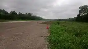
The airstrip
External links
This article is issued from Wikipedia. The text is licensed under Creative Commons - Attribution - Sharealike. Additional terms may apply for the media files.