Verel-Pragondran
Verel-Pragondran is a commune in the Savoie department in the Auvergne-Rhône-Alpes region in south-eastern France. It is part of the urban area of Chambéry.[3]
Verel-Pragondran | |
|---|---|
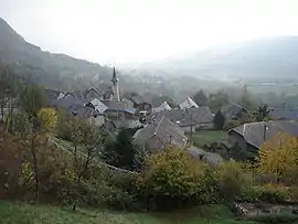 The church and surrounding buildings in Verel | |
Location of Verel-Pragondran | |
 Verel-Pragondran  Verel-Pragondran | |
| Coordinates: 45°36′29″N 5°56′57″E | |
| Country | France |
| Region | Auvergne-Rhône-Alpes |
| Department | Savoie |
| Arrondissement | Chambéry |
| Canton | Saint-Alban-Leysse |
| Intercommunality | Grand Chambéry |
| Government | |
| • Mayor (2020–2026) | Jean-Pierre Coendoz[1] |
| Area 1 | 6.53 km2 (2.52 sq mi) |
| Population | 480 |
| • Density | 74/km2 (190/sq mi) |
| Time zone | UTC+01:00 (CET) |
| • Summer (DST) | UTC+02:00 (CEST) |
| INSEE/Postal code | 73310 /73230 |
| Elevation | 432–1,500 m (1,417–4,921 ft) |
| 1 French Land Register data, which excludes lakes, ponds, glaciers > 1 km2 (0.386 sq mi or 247 acres) and river estuaries. | |
.JPG.webp)
View on the lac du Bourget from Pragondran's cliff.
Inhabitant are called in French Devrai-Gondraniers or Devrai-Gondranières.
Geography
Verel-Pragondran is a small village of a bit more than 400 persons. Its surface area is 6,53 km2, at an altitude between 432m et 1500m.
Verel-Pragondran is located near Chambéry (5 km).
See also
References
- "Répertoire national des élus: les maires". data.gouv.fr, Plateforme ouverte des données publiques françaises (in French). 2 December 2020.
- "Populations légales 2020". The National Institute of Statistics and Economic Studies. 29 December 2022.
- Unité urbaine 2020 de Chambéry (73601), INSEE
Wikimedia Commons has media related to Verel-Pragondran.
This article is issued from Wikipedia. The text is licensed under Creative Commons - Attribution - Sharealike. Additional terms may apply for the media files.