Van Diemen Gulf
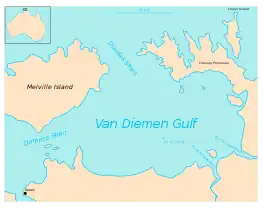
Van Diemen Gulf is a gulf in the Northern Territory of Australia. It connects to the Timor Sea in the north via Dundas Strait. Most of its area is also gazetted as a locality with the name Van Diemen Gulf.
.jpg.webp)
| Van Diemen Gulf | |
|---|---|
 Map showing the layout of Van Diemen Gulf. Darwin is in lower left corner. | |
 Van Diemen Gulf | |
| Coordinates | 11°49′S 131°57′E |
| Type | Gulf |
| Etymology | Anthony van Diemen.[1] |
| Basin countries | Australia |
| Max. length | 75 nautical miles (139 km; 86 mi) [2] |
| Max. width | 45 nautical miles (83 km; 52 mi) [2] |
History
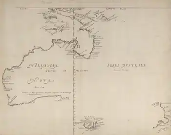
The gulf was named after the Dutch colonial governor, Anthony van Diemen (1593–1645).[3]
Phillip Parker King and his crew in the 76-tonne cutter HMS Mermaid surveyed the coastline in early 1818, encountering local Aboriginal people and proas sailed by Makassans, and passed by the Gulf on other voyages.[4]
Geography
The gulf connects to the Timor Sea in the north via Dundas Strait, and is also connected to the Beagle Gulf in the west by the Clarence Strait. It is partially enclosed by Melville Island and the Cobourg Peninsula, and measures about 140 kilometres (90 mi) by 80 kilometres (50 mi).[5]
Rivers draining into the Gulf include the South Alligator River, the East Alligator River, the Mary River, Wildman River and the Adelaide River. The Kakadu National Park adjoins its south-east coast.[6]

Administrative status
On 4 April 2007, most of the area occupied by the Van Diemen Gulf was gazetted as a locality with the name Van Diemen Gulf by the Northern Territory Government, who also included it in the local government area of the West Arnhem Region.[7][8][9]
References
- "Place Names Register Extract - "Van Diemen Gulf"". NT Place Names Register. Northern Territory Government. Retrieved 1 May 2019.
- Sailing Directions (Enroute), Pub. 175: North, West, and South Coasts of Australia (PDF). Sailing Directions. United States National Geospatial-Intelligence Agency. 2017. p. 27.
- . Encyclopædia Britannica (11th ed.). 1911.
- "King, Phillip Parker (1791–1856)". Australian Dictionary of Biography. Vol. 2. National Centre of Biography, Australian National University. 1967. ISSN 1833-7538. Retrieved 6 November 2020.
This article was first published in hardcopy in Australian Dictionary of Biography, Volume 2, (MUP), 1967 [but has been] amended since the original publication.
- "Van Diemen Gulf". Encyclopedia Britannica. Retrieved 6 November 2020.
- "Drainage Divisions" (PDF). Commonwealth of Australia. 2005. Archived from the original (PDF) on 1 April 2015. Retrieved 7 May 2015.
- "Place Names Register Extract - "Van Diemen Gulf" (locality)". NT Place Names Register. Northern Territory Government. Retrieved 27 April 2019.
{{cite web}}: Check|url=value (help) - "Extent of the locality of "Van Diemen Gulf"". NT Atlas and Spatial Data DirectorGovernment. Retrieved 27 April 2019.
- "Localities within West Arnhem Shire (sic)" (PDF). Place Names Committee. Northern Territory Government. 2 April 2007. Retrieved 27 April 2019.
