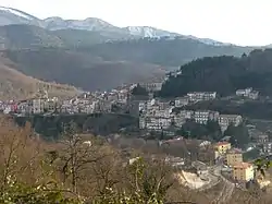
Vallerotonda
Vallerotonda (locally Vardónna) is a town and comune (municipality) in the region of Lazio in central Italy, in the province of Frosinone. The commune is situated on the Apennine Mountains and forms part of the Comino Valley.
Vallerotonda | |
|---|---|
| Comune di Vallerotonda | |
 | |
 Coat of arms | |
Location of Vallerotonda | |
 Vallerotonda Location of Vallerotonda in Italy  Vallerotonda Vallerotonda (Lazio) | |
| Coordinates: 41°33′N 13°55′E | |
| Country | Italy |
| Region | Lazio |
| Province | Frosinone (FR) |
| Frazioni | Centro, Valvori, Cerreto and Cardito. |
| Government | |
| • Mayor | Gianfranco Verallo |
| Area | |
| • Total | 59 km2 (23 sq mi) |
| Elevation | 620 m (2,030 ft) |
| Population (28 February 2017)[2] | |
| • Total | 1,539 |
| • Density | 26/km2 (68/sq mi) |
| Demonym | Vallerotondesi |
| Time zone | UTC+1 (CET) |
| • Summer (DST) | UTC+2 (CEST) |
| Postal code | 03040 |
| Dialing code | 0776 |
| Patron saint | St. Peter |
| Saint day | 7 April |
| Website | Official website |
Geography
The area is historically tied to the Mezzogiorno, the Italian "South", only relatively recently in the 1920s Fascist rule, was it transferred to the "central" province of Lazio along with Latina from the Terra di Lavoro, which was a giustizierato (circumscription) of the former Kingdom of Naples.
It borders the communes Acquafondata, Cervaro, Filignano, Rocchetta a Volturno, San Biagio Saracinisco, Sant'Elia Fiumerapido, and Viticuso.
External links
- Official website (in Italian)
- Website "la Ciociaria" (in Italian)
- "Superficie di Comuni Province e Regioni italiane al 9 ottobre 2011". Italian National Institute of Statistics. Retrieved 16 March 2019.
- "Popolazione Residente al 1° Gennaio 2018". Italian National Institute of Statistics. Retrieved 16 March 2019.
This article is issued from Wikipedia. The text is licensed under Creative Commons - Attribution - Sharealike. Additional terms may apply for the media files.