Upper Gundowring
Upper Gundowring is a locality in north east Victoria, Australia. The locality is in the Alpine Shire local government area, 335 kilometres (208 mi) north east of the state capital, Melbourne.
| Upper Gundowring Victoria | |
|---|---|
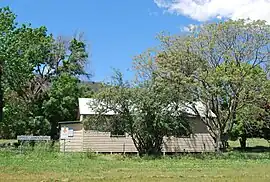 Public hall at Upper Gundowring, 2009 | |
 Upper Gundowring | |
| Coordinates | 36°29′25″S 147°04′04″E |
| Population | 99 (2016 census)[1] |
| Postcode(s) | 3691 |
| Location | |
| LGA(s) | Alpine Shire |
| State electorate(s) | Benambra |
| Federal division(s) | Indi |
At the 2016 census, Upper Gundowring had a population of 99.[1]
References
- Australian Bureau of Statistics (27 June 2017). "Upper Gundowring". 2016 Census QuickStats. Retrieved 7 August 2017.
External links
![]() Media related to Upper Gundowring at Wikimedia Commons
Media related to Upper Gundowring at Wikimedia Commons
Localities in the Alpine Shire | ||
|---|---|---|
| Town |
| |
| Locality |
| |
^ - Territory divided with another LGA | ||
This article is issued from Wikipedia. The text is licensed under Creative Commons - Attribution - Sharealike. Additional terms may apply for the media files.