1996 United States presidential election in Montana
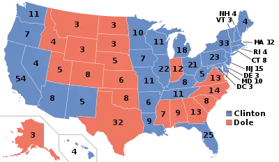
The 1996 United States presidential election in Montana took place on November 5, 1996, as part of the 1996 United States presidential election. Voters chose three representatives, or electors to the Electoral College, who voted for president and vice president.
| |||||||||||||||||||||||||||||||||
| |||||||||||||||||||||||||||||||||
 County Results
| |||||||||||||||||||||||||||||||||
| |||||||||||||||||||||||||||||||||
| Elections in Montana |
|---|
 |
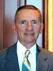
Montana voted for Senate Majority Leader Bob Dole over President Bill Clinton by a slim margin of 2.88%.[1] Billionaire businessman Ross Perot (Reform Party of the United States of America-TX) finished in third, with 13.56% of the popular vote in Montana.[1] As of the 2020 presidential election, this is the last election in which Sheridan County, Dawson County, and Mineral County voted for the Democratic candidate.
With 13.56% of the popular vote, Montana would prove to be Ross Perot's second strongest state in the 1996 election after Maine.[2]
Montana was one of three states won by Clinton in 1992 that Bob Dole was able to flip, the others being Colorado and Georgia. This was also the first election since 1912 in which Montana voted differently than nearby California.
Results
| 1996 United States presidential election in Montana[1] | ||||||
|---|---|---|---|---|---|---|
| Party | Candidate | Running mate | Votes | Percentage | Electoral votes | |
| Republican | Bob Dole | Jack Kemp | 179,652 | 44.11% | 3 | |
| Democratic | Bill Clinton | Al Gore | 167,922 | 41.23% | 0 | |
| Reform | Ross Perot | Patrick Choate | 55,229 | 13.56% | 0 | |
| Libertarian | Harry Browne | Jo Jorgensen | 2,526 | 0.62% | 0 | |
| Natural Law (write in) | John Hagelin | Mike Tompkins | 1,754 | 0.43% | 0 | |
| Constitutional (write in) | Howard Phillips | Herbert Titus | 152 | 0.04% | 0 | |
| (write in) | Charles E. Collins | Rosemary Giumarra | 20 | 0.00% | 0 | |
| Independent (write in) | Write-ins | 5 | 0.00 | 0 | ||
| Socialist (write in) | Mary Cal Hollis | Eric Chester | 1 | 0.00 | 0 | |
By county
| County | Clinton% | Clinton# | Dole% | Dole# | Others% | Others# |
|---|---|---|---|---|---|---|
| Beaverhead | 29.0% | 1,164 | 60.1% | 2,414 | 11.0% | 441 |
| Big Horn | 57.9% | 2,453 | 31.5% | 1,336 | 10.6% | 450 |
| Blaine | 45.5% | 1,316 | 39.0% | 1,127 | 15.6% | 450 |
| Broadwater | 30.7% | 603 | 52.3% | 1,029 | 17.0% | 334 |
| Carbon | 38.9% | 1,854 | 45.1% | 2,147 | 16.0% | 761 |
| Carter | 19.6% | 150 | 68.2% | 522 | 12.2% | 93 |
| Cascade | 44.9% | 15,707 | 40.8% | 14,291 | 14.3% | 5,008 |
| Chouteau | 32.9% | 1,039 | 52.6% | 1,660 | 14.5% | 458 |
| Custer | 39.7% | 2,115 | 46.3% | 2,467 | 14.0% | 747 |
| Daniels | 38.9% | 510 | 42.5% | 558 | 18.6% | 244 |
| Dawson | 40.7% | 1,903 | 40.5% | 1,890 | 18.8% | 880 |
| Deer Lodge | 66.5% | 3,331 | 17.6% | 883 | 15.9% | 796 |
| Fallon | 29.8% | 452 | 51.3% | 778 | 18.9% | 286 |
| Fergus | 30.1% | 1,866 | 59.3% | 3,671 | 10.6% | 657 |
| Flathead | 32.4% | 10,452 | 51.3% | 16,542 | 16.2% | 5,231 |
| Gallatin | 37.7% | 10,972 | 50.1% | 14,559 | 12.2% | 3,547 |
| Garfield | 14.3% | 107 | 75.3% | 562 | 10.3% | 77 |
| Glacier | 56.0% | 2,292 | 31.0% | 1,270 | 13.0% | 533 |
| Golden Valley | 26.2% | 128 | 58.2% | 284 | 15.6% | 76 |
| Granite | 30.5% | 429 | 52.1% | 733 | 17.4% | 245 |
| Hill | 49.5% | 3,517 | 36.6% | 2,601 | 14.0% | 993 |
| Jefferson | 37.0% | 1,775 | 46.8% | 2,248 | 16.2% | 778 |
| Judith Basin | 33.8% | 452 | 56.3% | 753 | 9.9% | 133 |
| Lake | 38.7% | 4,195 | 43.6% | 4,723 | 17.7% | 1,922 |
| Lewis and Clark | 43.5% | 11,535 | 43.9% | 11,665 | 12.6% | 3,347 |
| Liberty | 32.6% | 379 | 54.6% | 634 | 12.8% | 149 |
| Lincoln | 34.4% | 2,705 | 45.2% | 3,552 | 20.5% | 1,609 |
| McCone | 31.1% | 390 | 49.0% | 615 | 20.0% | 251 |
| Madison | 27.3% | 955 | 56.8% | 1,984 | 15.9% | 556 |
| Meagher | 30.0% | 281 | 54.0% | 505 | 16.0% | 150 |
| Mineral | 40.7% | 658 | 34.0% | 549 | 25.3% | 408 |
| Missoula | 49.3% | 21,874 | 36.1% | 16,034 | 14.6% | 6,474 |
| Musselshell | 31.4% | 652 | 54.0% | 1,121 | 14.6% | 303 |
| Park | 34.4% | 2,564 | 51.5% | 3,837 | 14.1% | 1,047 |
| Petroleum | 21.4% | 62 | 64.1% | 186 | 14.5% | 42 |
| Phillips | 28.1% | 705 | 55.4% | 1,392 | 16.5% | 414 |
| Pondera | 37.9% | 1,123 | 48.5% | 1,438 | 13.6% | 402 |
| Powder River | 22.6% | 236 | 63.4% | 663 | 14.0% | 146 |
| Powell | 34.0% | 952 | 45.5% | 1,274 | 20.6% | 576 |
| Prairie | 33.2% | 259 | 53.5% | 417 | 13.3% | 104 |
| Ravalli | 32.0% | 5,200 | 50.1% | 8,138 | 17.9% | 2,902 |
| Richland | 35.3% | 1,614 | 44.2% | 2,021 | 20.4% | 933 |
| Roosevelt | 53.0% | 2,118 | 30.3% | 1,209 | 16.8% | 670 |
| Rosebud | 45.6% | 1,681 | 38.4% | 1,413 | 16.0% | 589 |
| Sanders | 33.8% | 1,573 | 43.8% | 2,043 | 22.4% | 1,045 |
| Sheridan | 48.8% | 1,187 | 34.2% | 832 | 17.1% | 416 |
| Silver Bow | 63.4% | 11,199 | 22.1% | 3,909 | 14.5% | 2,569 |
| Stillwater | 33.7% | 1,282 | 49.2% | 1,871 | 17.0% | 647 |
| Sweet Grass | 26.3% | 469 | 62.2% | 1,109 | 11.5% | 204 |
| Teton | 35.7% | 1,188 | 51.1% | 1,701 | 13.1% | 437 |
| Toole | 35.2% | 874 | 48.5% | 1,203 | 16.3% | 405 |
| Treasure | 34.3% | 171 | 47.6% | 237 | 18.1% | 90 |
| Valley | 39.8% | 1,674 | 43.7% | 1,838 | 16.5% | 695 |
| Wheatland | 35.9% | 391 | 51.8% | 563 | 12.3% | 134 |
| Wibaux | 32.1% | 197 | 46.3% | 284 | 21.5% | 132 |
| Yellowstone | 41.1% | 22,992 | 47.2% | 26,367 | 11.7% | 6,523 |
Counties that flipped from Democratic to Republican
References
- "Dave Leip's Atlas of U.S. Presidential Elections".
- "1996 Presidential Election Statistics". Dave Leip’s Atlas of U.S. Presidential Elections. Retrieved March 5, 2018.


