Umm an Namil Island
Umm al Namil (Arabic: جزيرة ام النمل)(Translation: Mother of ants) is an island belonging to Kuwait, located within Kuwait Bay, in Persian Gulf. The island is at shortest, 600 metres (2,000 feet) away from the Kuwaiti mainland.
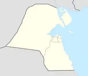 Shown within Kuwait  Umm an Namil Island (Near East) | |
| Location | Kuwait |
|---|---|
| Region | Mesopotamia |
| Coordinates | 29°22′54″N 47°52′01″E (approximate) |
| Location | Umm an Namil Island, Kuwait |
|---|---|
| Coordinates | 29°23′14″N 47°52′16″E |
| Tower | |
| Foundation | concrete base |
| Construction | metal skeletal tower |
| Height | 16 m (52 ft) |
| Shape | square pyramidal tower with balcony and lantern[1][2] |
| Markings | red and white horizontal bands tower |
| Power source | solar power |
| Operator | Kuwait Port Authority |
| Light | |
| Focal height | 17 m (56 ft) |
| Characteristic | Fl W 10s |
The island is known to be the site of several archeological finds, mainly from the ancient Islamic era, Dilmun civilization, Hellenistic (including Seleucid), and the Bronze Age.[3][4][5]
See also
References
- Rowlett, Russ. "Lighthouses of Kuwait". The Lighthouse Directory. University of North Carolina at Chapel Hill. Retrieved 2016-10-08.
- NGA List of Lights – Pub.112 Retrieved 8 October 2016
- Connan, Jacques; Carter, Robert (2007). "A geochemical study of bituminous mixtures from Failaka and Umm an-Namel (Kuwait), from the Early Dilmun to the Early Islamic period". Jacques Connan, Robert Carter. 18 (2): 139–181. doi:10.1111/j.1600-0471.2007.00283.x.
- "Kuwait's archaeological sites reflect human history & civilizations (2:50 – 3:02)". Ministry of Interior News. Archived from the original on 2021-12-21.
- Calvet, Yves (1989). "Failaka and the Northern Part of Dilmun". Proceedings of the Seminar for Arabian Studies. 19: 5–11. JSTOR 41223078.
| Inhabited islands | |
|---|---|
| Uninhabited islands | |
Capital: Kuwait City | |
| Kuwait City districts | |
| Shuwaikh Quarter |
|
| Governorate areas | |
| Islands | |
This article is issued from Wikipedia. The text is licensed under Creative Commons - Attribution - Sharealike. Additional terms may apply for the media files.