Typhoon Wutip (2019)
Typhoon Wutip, known in the Philippines as Tropical Depression Betty, was the most powerful February typhoon on record, surpassing Typhoon Higos of 2015.[1][2] The third tropical cyclone, second tropical storm, and the first typhoon of the 2019 Pacific typhoon season, Wutip originated from a low-pressure area on February 16, 2019, that generally tracked westward, passing just south of the Federated States of Micronesia (FSM), before organizing to a tropical depression on February 18. The depression was later classified a tropical storm a day later, attaining the name Wutip from the Japan Meteorological Agency. The storm gradually intensified before it underwent rapid intensification while passing to the southwest of Guam on February 23 and reached its first peak intensity. With winds of 270 km/h (165 mph) estimated by the Joint Typhoon Warning Center, Wutip became the first Category 5-equivalent super typhoon on record in the month of February. Wutip underwent an eyewall replacement cycle shortly afterward, causing the storm to weaken as it turned northwest. The storm finished its cycle on February 24, resulting in Wutip rapidly intensifying once again. Wutip reached a secondary peak intensity the following day, again attaining Category 5-equivalent winds. Afterward, Wutip rapidly weakened throughout its lifespan from strong wind shear as it moved northwestward, before dissipating over the Philippine Sea on March 2.
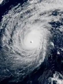 Wutip at its secondary peak intensity west of the island of Guam, on February 25. | |
| Meteorological history | |
|---|---|
| Formed | February 18, 2019 |
| Dissipated | March 2, 2019 |
| Violent typhoon | |
| 10-minute sustained (JMA) | |
| Highest winds | 195 km/h (120 mph) |
| Lowest pressure | 920 hPa (mbar); 27.17 inHg |
| Category 5-equivalent super typhoon | |
| 1-minute sustained (SSHWS/JTWC) | |
| Highest winds | 270 km/h (165 mph) |
| Lowest pressure | 895 hPa (mbar); 26.43 inHg |
| Overall effects | |
| Casualties | None reported |
| Damage | ≥$3.3 million (2019 USD) |
| Areas affected | Guam, Federated States of Micronesia, Northern Mariana Islands |
| IBTrACS | |
Part of the 2019 Pacific typhoon season | |
In preparation of Wutip, watches and warnings were in effect across the FSM and Mariana Islands by the National Weather Service office in Tiyan, Guam. In Chuuk and Yap States, Wutip produced inundation and powerful winds that destroyed crops and damaged around 160 houses, leaving 165 people homeless. On February 23, as Wutip was approaching Guam, power outages were reported across the island, and by February 25, Wutip had caused heavy damage in infrastructure, adding to the total of at least $3.3 million (2019 USD) in damages.[3][4] There were no casualties reported in the affected areas nonetheless. In response to the effects, a disaster declaration from Guam governor Lou Leon Guerrero and another from president of the Federated States of Micronesia Peter M. Christian were issued and later approved by Donald Trump a few months after the storm.
Meteorological history

Tropical storm (39–73 mph, 63–118 km/h)
Category 1 (74–95 mph, 119–153 km/h)
Category 2 (96–110 mph, 154–177 km/h)
Category 3 (111–129 mph, 178–208 km/h)
Category 4 (130–156 mph, 209–251 km/h)
Category 5 (≥157 mph, ≥252 km/h)
Unknown
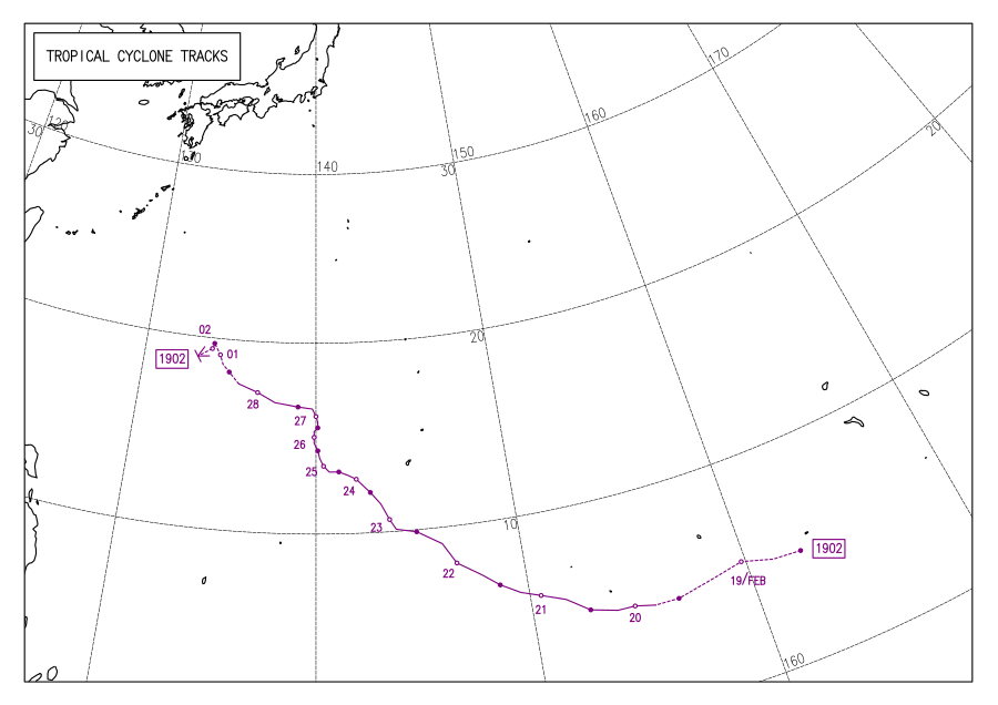
Around early February 2019, a large mass of cumulonimbus clouds accumulated near the Marshall Islands. Initially disorganized, the slow-moving cluster consolidated into a more cohesive system.[5] During February 16, the low-pressure system shifted westward while southeast of Kosrae,[6] when a vigorous trade wind convergence north of the disturbance triggered sporadic showers and thunderstorms.[7] Convection broadened over a weak low-level circulation, which on February 18, prompted the American-based Joint Typhoon Warning Center (JTWC)[nb 1] to issue a Tropical Cyclone Formation Alert when the tropical disturbance was situated over an area of low wind shear and warm sea surface temperatures, being conducive for further tropical cyclogenesis.[9] Following more organizing that same day, the Japan Meteorological Agency (JMA)[nb 2] identified the system as a tropical depression,[10] shortly before the JTWC assigned the system as Tropical Depression 02W on February 19 when it had improved its convective banding.[11] Both agencies later categorize the depression as a tropical storm the same day, with the JMA assigning the name Wutip to the storm.[12][13]
On February 20, convection rapidly deepened offset towards the west of the center,[14] and subsequently led to Wutip attaining severe tropical storm status from the JMA.[15] Early on February 21, the intense rainbands completely wrapped around the defined circulation; Wutip was classified a typhoon by this time through the usage of the Dvorak technique by both the JMA and the JTWC. Microwave imaging indicated an eye after the formation of a central dense overcast (CDO) that obscured the feature.[16] By February 22, the eye of the gradually strengthening storm became visible on satellite imagery.[17] During its steady consolidation evidenced by the symmetric CDO, the very compact system steered northwestward under the influence of a subtropical ridge due to an approaching shortwave trough,[18][19] while being located 169 km (105 mi) north of Faraulep and 370 km (230 mi) south of Guam.[20] Improvement was made on its contracted eyewall throughout February 23. Radar imagery displayed northern spiral banding features advecting over Guam.[21] Despite a decrease in sea surface temperatures, the diminishment of wind shear combined with the possession of excellent upper-level outflow commenced a period of rapid intensification.[22]
.gif)
By 12:00 UTC, Wutip reached its initial peak intensity; the JMA estimated 10-minute sustained winds of 195 km/h (120 mph) and the lowest barometric pressure of 920 hPa (27.17 inHg) around that time.[23] The JTWC operationally estimated 1-minute sustained winds of 250 km/h (155 mph), re-classifying Wutip as a super typhoon;[24] however, post-season analysis determined that it had attain winds of 270 km/h (165 mph),[25] making Wutip equivalent to a Category 5 hurricane on the Saffir–Simpson hurricane wind scale. This made Wutip the most powerful typhoon in the month of February, surpassing Typhoon Higos of 2015,[1] and in addition, become the first and only tropical cyclone in the Northern Hemisphere with Category 5-equivalent winds in the month of February.[26] Shortly thereafter, Wutip initiated an eyewall replacement cycle and weakened from it.[27] Cloud tops eroded off the western portion from dry air entrainment alongside a region of low ocean heat content.[28] Upon completion on February 24, the eyewall thickened and convection was replenished and reorganized,[29] becoming well-defined and axisymmetric with annular characteristics, resulting in the storm resuming a trend of rapid intensification.[30] Wutip again became a Category 5-equivalent typhoon on February 25, reaching a secondary peak intensity with 10-minute winds of 185 km/h (115 mph),[23] 1-minute winds of 260 km/h (160 mph),[31] and an atmospheric pressure of 935 hPa (27.61 inHg).[23]
Immediately afterward, a significant increase in wind shear began weakening Wutip quickly when the center had become cloud-filled.[32] As a consequence of the deterioration of its structure, the eye was no longer detected on satellite imagery.[33] The storm reached the southern edge of prevailing westerlies that provided escalated shearing, although it still kept its robust ventilation by being positioned under a westerly jet stream.[34][35] On February 27, the cloud pattern became more disorganized while Wutip was situated east of an upper-level trough,[36] before it was downgraded to tropical storm strength.[37] The deep convection soon detached and dissipated, preventing additional development.[38] By the following day, wind shear had completely exposed the well-organized circulation.[39] Wutip was downgraded further to a tropical depression after estimations of 45 km/h (30 mph) were recorded.[40] On the same day, Wutip entered the Philippine Area of Responsibility in the Philippine Sea, receiving the local name Betty from PAGASA.[41] The JTWC issued its final warning on Wutip, indicating that the unfavorable conditions would make its elongated circulation disintegrate.[42][43] The JMA would keep monitoring the depression until it had dissipated on March 2 near east of the Philippines.[23]
Preparations and impact
Federated States of Micronesia

Tropical storm watches and warnings were issued for Chuuk, Pohnpei, and Yap State of the Federated States of Micronesia by the National Weather Service office in Tiyan, Guam as Tropical Depression 02W was approaching the FSM on February 19;[44] the tropical storm warning for Faraulep in Yap State was later canceled.[45] The advisories were upgraded to typhoon watches and warnings after Tropical Depression 02W had intensified into Tropical Storm Wutip on February 20, with forecasts stating that Wutip would soon strengthen into a typhoon.[46]
Wutip passed over Chuuk, Pohnpei and Yap States with winds of more than 160 km/h (100 mph) from February 19 to 22, and damaged or destroyed approximately 160 houses and displaced 165 people in Chuuk and Yap.[47] Despite no casualties, many crops were ruined from the saltwater produced by Wutip and many breadfruit and banana trees were downed.[48] Food sources were destroyed by the powerful winds along with sea water inundation; the latter had also rendered water sources unsafe for drinking. Local authorities declared states of emergency in response to the destruction.[47] Wutip caused heavy preliminary damage in infrastructure and agriculture and costed a total of $2 million.[4]
Guam
Guam was still reeling from Typhoon Mangkhut as hundreds fled to emergency shelters; over 430 children and adults sought refuge at 5 different emergency shelters.[49] Public schools were closed in preparation of Wutip on February 22.[50] The same day, Cope North, an annual military exercise that takes place around Guam, was paused "as a precautionary measure due to hazardous and potentially damaging winds," according to the Pacific Air Forces.[51] A team of 18 from the Federal Emergency Management Agency (FEMA) assisted Guam with emergencies.[52] Civil defense officials warned Guam residents that winds between 64–72 km/h (40–45 mph) and rainfall up to 15.24 cm (6.00 in) were expected, and advised them to stay indoors until the storm had passed.[53] Lieutenant Governor Josh Tenorio put Guam and the military bases under Condition of Readiness (COR) 2,[54] before upgrading it to COR 1.[55] Over 20 flights to and from Guam were canceled,[56] leading to the loss of 4,993 seats.[57]
The Guam Power Authority reported isolated power outages occurring across Guam.[58] Wutip's closest point of approach was on the 24th, when it was about 266 kilometres (165 mi) south of the island. Wutip had dumped 43 cm (17 in) of rain in Inarajan, 30 cm (12 in) in Dandan, and 15 to 20 cm (6 to 8 in) elsewhere in the island.[59] Inarajan experienced more significant damage, with obstructed roads and many downed trees and power lines along with major flooding. No injury or serious damage were reported.[60] Preliminary damage in infrastructure for Wutip totaled $1.3 million.[3]
Northern Mariana Islands
Tropical storm watches were in effect across the islands of Saipan, Tinian, and Rota. Families were still residing in tents due to the effects from Typhoon Yutu, and were encouraged to seek emergency shelter.[45] A total of 83 individuals took shelter during Wutip's passage.[61] The president of the Asian Football Confederation, Salman bin Ibrahim Al Khalifa, was set to visit Saipan on the 25th, but postponed the visit in precaution of Wutip.[62] The tropical storm watch in Rota was later upgraded to a typhoon warning, but was canceled on February 24 by Lieutenant Governor Arnold Palacios when Wutip headed towards a different direction from the islands and no longer posed a threat. In Rota however, winds of 55–70 km/h (35–45 mph) and gusts of 70–90 km/h (45–55 mph) swept across the village of Songsong and waves of 4.9–6.1 m (16–20 ft) to as high as 7.6 m (25 ft) surfed along the east- and south-facing reefs, leading to coastal flooding.[63] No injuries were reported and public roadways across the islands remained clear of debris.[61] As a result, schools were reopened across the Northern Mariana Islands along with Guam on February 25.[64]
Aftermath

The Federated States of Micronesia President Peter M. Christian issued a national disaster declaration on March 11, due to the effects of the storm, and requested international assistance.[65] U.S. Chargé d'affaires Heather Coble declared a disaster the following day, allowing the United States Agency for International Development (USAID), FEMA, and the federal government of the FSM to carry out a damage assessment and relieve activities supporting agriculture and food security,[66] after 11,575 people were left food insecure.[65] The USAID supplied $100,000 to aid immediate disaster relief activities for affected populations.[47] A multinational team arrived at Lower Mortlock Islands of Chuuk State to assist local communities as part of Pacific Partnership 2019 on March 31, which included helping the state recover after the storm.[67]
On May 7, U.S. President Donald Trump declared Wutip a disaster under the Compact of Free Association between the national governments, due to damage resulting from Wutip.[68] Relief and reconstruction funding from the USAID totaled more than $22.3 million.[66] On May 11, Donald Trump approved the disaster declaration requested by Guam Governor Lou Leon Guerrero on February 23 due to the impact the Mariana Islands had from Wutip. Tracy C. Haynes was appointed by Trump as Federal Coordinating Officer (FCO) for recovery operations across Guam.[69][70]
See also
- Weather of 2019
- Tropical cyclones in 2019
- Other systems named Wutip
- Other systems named Betty
- Typhoon Keith – A Category 5-equivalent super typhoon that affected some of the same areas in 1997
- Typhoon Maysak (2015) – The most powerful pre-April typhoon on record; struck Micronesia and the Philippines
- Typhoon Jelawat (2018) – An early-season Category 4-equivalent super typhoon from 2018, which affected some of the same areas
- Typhoon Yutu – A powerful Category 5-equivalent super typhoon that devastated Saipan and Tinian in the Northern Mariana Islands during the previous year
- Typhoon Surigae – The most powerful April typhoon on record
Notes
- The Joint Typhoon Warning Center is a joint United States Navy – United States Air Force task force that issues tropical cyclone warnings for the western Pacific Ocean and other regions.[8]
- The Japan Meteorological Agency is the official Regional Specialized Meteorological Center for the western Pacific Ocean.
References
- Matthew Cappucci (February 25, 2019). "The strongest February typhoon on record packs 180 mph gusts, sideswiping Guam". The Washington Post. Archived from the original on May 17, 2019. Retrieved May 21, 2019.
- Kristina Pydynowski; Robert Richards (February 23, 2019). "Wutip becomes strongest super typhoon in February as it lashes Guam with rain, wind". Accuweather. Archived from the original on February 22, 2019. Retrieved February 23, 2019.
- "Preliminary cost estimate of Wutip: More than $1.3 million". Guam Pacific Daily News. March 1, 2019. Archived from the original on April 13, 2023. Retrieved May 21, 2019.
- Losinio, Louella (April 12, 2019). "Post-Wutip damages to FSM cost at least $2M". PNC News First. Archived from the original on November 26, 2022. Retrieved November 26, 2022.
- Pacific El Niño-Southern Oscillation (ENSO) Applications Climate Center (March 20, 2019). "Pacific ENSO Update: 1st Quarter, 2019" (PDF). Pacific ENSO Update. United States National Oceanic and Atmospheric Administration's National Weather Service. 25 (1). Retrieved September 1, 2023.
- Warning and Summary 161200 (TXT) (Report). Tokyo, Japan: Japan Meteorological Agency. February 16, 2019. Archived from the original on April 1, 2023. Retrieved April 1, 2023 – via Iowa Environmental Mesonet.
- ...TROPICAL DISTURBANCE SOUTHEAST OF KOSRAE... (Report). Tiyan, Guam: National Weather Service. February 17, 2019. Archived from the original on April 4, 2023. Retrieved April 1, 2023 – via Iowa Environmental Mesonet.
- "Joint Typhoon Warning Center Mission Statement". Joint Typhoon Warning Center. 2011. Archived from the original on July 26, 2007. Retrieved January 1, 2014.
- Tropical Cyclone Formation Alert (180300 February 2019) (TXT) (Report). Pearl Harbor, Hawaii: Joint Typhoon Warning Center. February 18, 2019. Archived from the original on February 23, 2023. Retrieved February 23, 2023 – via Iowa Environmental Mesonet.
- Warning and Summary 181800 (TXT) (Report). Tokyo, Japan: Japan Meteorological Agency. February 18, 2019. Archived from the original on February 23, 2023. Retrieved March 29, 2023 – via Iowa Environmental Mesonet.
- Prognostic Reasoning for Tropical Depression 02W (Two) Warning No. 1 (TXT) (Report). Pearl Harbor, Hawaii: Joint Typhoon Warning Center. February 19, 2019. Archived from the original on February 25, 2023. Retrieved February 25, 2023 – via Iowa Environmental Mesonet.
- Warning 191800 (TXT) (Report). Tokyo, Japan: Japan Meteorological Agency. February 19, 2019. Archived from the original on February 25, 2023. Retrieved February 25, 2023 – via Iowa Environmental Mesonet.
- Tropical Storm 02W (Wutip) Warning No. 3 (Report). Pearl Harbor, Hawaii: Joint Typhoon Warning Center. February 19, 2019. Archived from the original (TXT) on April 5, 2023. Retrieved April 5, 2023.
- Prognostic Reasoning for Tropical Storm 02W (Wutip) Warning No. 7 (TXT) (Report). Pearl Harbor, Hawaii: Joint Typhoon Warning Center. February 20, 2019. Retrieved September 8, 2023 – via Iowa Environmental Mesonet.
- Warning 201200 (TXT) (Report). Tokyo, Japan: Japan Meteorological Agency. February 20, 2019. Archived from the original on March 15, 2023. Retrieved March 5, 2023 – via Iowa Environmental Mesonet.
- Prognostic Reasoning for Tropical Storm 02W (Wutip) Warning No. 8 (TXT) (Report). Pearl Harbor, Hawaii: Joint Typhoon Warning Center. February 21, 2019. Archived from the original on March 15, 2023. Retrieved April 11, 2023 – via Iowa Environmental Mesonet.
- Prognostic Reasoning for Super Typhoon 02W (Wutip) Warning No. 12 (TXT) (Report). Pearl Harbor, Hawaii: Joint Typhoon Warning Center. February 22, 2019. Archived from the original on March 20, 2023. Retrieved April 11, 2023 – via Iowa Environmental Mesonet.
- Prognostic Reasoning for Super Typhoon 02W (Wutip) Warning No. 14 (TXT) (Report). Pearl Harbor, Hawaii: Joint Typhoon Warning Center. February 22, 2019. Archived from the original on March 20, 2023. Retrieved April 11, 2023 – via Iowa Environmental Mesonet.
- Prognostic Reasoning for Typhoon 02W (Wutip) Warning No. 15 (Report). Pearl Harbor, Hawaii: Joint Typhoon Warning Center. February 22, 2019. Archived from the original (TXT) on February 23, 2019. Retrieved April 30, 2023.
- Gutro, Rob (February 22, 2023). "NASA-NOAA Satellite Analyzes Typhoon Wutip". blogs.nasa.gov. Retrieved September 12, 2023.
- Prognostic Reasoning for Typhoon 02W (Wutip) Warning No. 17 (TXT) (Report). Pearl Harbor, Hawaii: Joint Typhoon Warning Center. February 23, 2019. Archived from the original on March 27, 2023. Retrieved March 27, 2023 – via Iowa Environmental Mesonet.
- Prognostic Reasoning for Super Typhoon 02W (Wutip) Warning No. 18 (TXT) (Report). Pearl Harbor, Hawaii: Joint Typhoon Warning Center. February 23, 2019. Archived from the original on March 27, 2023. Retrieved March 27, 2023 – via Iowa Environmental Mesonet.
- Annual Report on Activities of the RSMC Tokyo – Typhoon Center 2019 (PDF) (Report). Tokyo, Japan: Japan Meteorological Agency. Archived (PDF) from the original on May 4, 2021. Retrieved March 28, 2023.
- Super Typhoon 02W (Wutip) Warning No. 18 (Report). Pearl Harbor, Hawaii: Joint Typhoon Warning Center. February 23, 2019. Archived from the original (TXT) on April 3, 2023. Retrieved April 3, 2023.
- "Western North Pacific Ocean Best Track Data". Pearl Harbor, Hawaii: Joint Typhoon Warning Center. Archived from the original on October 2, 2019. Retrieved April 5, 2023.
- Teo Blašković (February 24, 2019). "Super Typhoon "Wutip" becomes the strongest February typhoon in West Pacific Ocean". The Watchers. Archived from the original on February 24, 2019. Retrieved May 21, 2019.
- Prognostic Reasoning for Super Typhoon 02W (Wutip) Warning No. 19 (TXT) (Report). Pearl Harbor, Hawaii: Joint Typhoon Warning Center. February 23, 2019. Archived from the original on March 27, 2023. Retrieved March 27, 2023 – via Iowa Environmental Mesonet.
- Prognostic Reasoning for Super Typhoon 02W (Wutip) Warning No. 20 (TXT) (Report). Pearl Harbor, Hawaii: Joint Typhoon Warning Center. February 24, 2019. Archived from the original on March 27, 2023. Retrieved April 2, 2023 – via Iowa Environmental Mesonet.
- Prognostic Reasoning for Super Typhoon 02W (Wutip) Warning No. 23 (TXT) (Report). Pearl Harbor, Hawaii: Joint Typhoon Warning Center. February 24, 2019. Archived from the original on March 27, 2023. Retrieved April 2, 2023 – via Iowa Environmental Mesonet.
- Prognostic Reasoning for Super Typhoon 02W (Wutip) Warning No. 25 (TXT) (Report). Pearl Harbor, Hawaii: Joint Typhoon Warning Center. February 25, 2019. Archived from the original on April 3, 2023. Retrieved April 2, 2023 – via Iowa Environmental Mesonet.
- Super Typhoon 02W (Wutip) Warning No. 25 (Report). Pearl Harbor, Hawaii: Joint Typhoon Warning Center. February 25, 2019. Archived from the original (TXT) on April 3, 2023. Retrieved April 3, 2023.
- Prognostic Reasoning for Typhoon 02W (Wutip) Warning No. 29 (TXT) (Report). Pearl Harbor, Hawaii: Joint Typhoon Warning Center. February 26, 2019. Archived from the original on March 28, 2023. Retrieved March 28, 2023 – via Iowa Environmental Mesonet.
- Prognostic Reasoning for Typhoon 02W (Wutip) Warning No. 30 (TXT) (Report). Pearl Harbor, Hawaii: Joint Typhoon Warning Center. February 26, 2019. Archived from the original on March 28, 2023. Retrieved March 28, 2023 – via Iowa Environmental Mesonet.
- Prognostic Reasoning for Typhoon 02W (Wutip) Warning No. 31 (TXT) (Report). Pearl Harbor, Hawaii: Joint Typhoon Warning Center. February 26, 2019. Archived from the original on March 28, 2023. Retrieved April 2, 2023 – via Iowa Environmental Mesonet.
- Prognostic Reasoning for Tropical Storm 02W (Wutip) Warning No. 35 (TXT) (Report). Pearl Harbor, Hawaii: Joint Typhoon Warning Center. February 27, 2019. Archived from the original on March 28, 2023. Retrieved March 28, 2023 – via Iowa Environmental Mesonet.
- Prognostic Reasoning for Typhoon 02W (Wutip) Warning No. 33 (TXT) (Report). Pearl Harbor, Hawaii: Joint Typhoon Warning Center. February 27, 2019. Archived from the original on March 28, 2023. Retrieved March 28, 2023 – via Iowa Environmental Mesonet.
- Tropical Storm 02W (Wutip) Warning No. 34 (Report). Pearl Harbor, Hawaii: Joint Typhoon Warning Center. February 27, 2019. Archived from the original (TXT) on April 3, 2023. Retrieved April 3, 2023.
- Prognostic Reasoning for Tropical Storm 02W (Wutip) Warning No. 35 (TXT) (Report). Pearl Harbor, Hawaii: Joint Typhoon Warning Center. February 27, 2019. Archived from the original on March 28, 2023. Retrieved March 28, 2023 – via Iowa Environmental Mesonet.
- Prognostic Reasoning for Tropical Storm 02W (Wutip) Warning No. 36 (TXT) (Report). Pearl Harbor, Hawaii: Joint Typhoon Warning Center. February 28, 2019. Archived from the original on March 28, 2023. Retrieved March 28, 2023 – via Iowa Environmental Mesonet.
- Tropical Depression 02W (Wutip) Warning No. 38 (Report). Pearl Harbor, Hawaii: Joint Typhoon Warning Center. February 28, 2019. Archived from the original (TXT) on April 3, 2023. Retrieved April 3, 2023.
- Rappler.com (February 28, 2019). "Tropical Depression Betty enters PAR, but poses no threat". Rappler. Archived from the original on September 30, 2019. Retrieved September 30, 2019.
- Prognostic Reasoning for Tropical Depression 02W (Wutip) Warning No. 38 (TXT) (Report). Pearl Harbor, Hawaii: Joint Typhoon Warning Center. February 28, 2019. Archived from the original on March 28, 2023. Retrieved March 28, 2023 – via Iowa Environmental Mesonet.
- Tropical Depression 02W (Wutip) Warning No. 39 (TXT) (Report). Pearl Harbor, Hawaii: Joint Typhoon Warning Center. February 28, 2019. Archived from the original on March 28, 2023. Retrieved March 28, 2023 – via Iowa Environmental Mesonet.
- "Feb. 19, 2019 – A NASA Infrared Look at Tropical Depression 02W, Warnings Posted". blogs.nasa.gov. February 19, 2019. Archived from the original on December 1, 2022. Retrieved December 1, 2022.
- "Northern Marianas, Guam prepare for Typhoon Wutip". RNZ. February 22, 2019. Archived from the original on November 1, 2022. Retrieved November 1, 2022.
- "Feb. 20, 2019 – NASA Finds Tropical Cyclone Wutip Organizing". blogs.nasa.gov. February 20, 2019. Archived from the original on December 1, 2022. Retrieved December 1, 2022.
- "Micronesia, Federated States of". USAID. Archived from the original on January 31, 2022. Retrieved March 30, 2023.
- Weiss, Jasmine Stole (February 23, 2019). "Typhoon Wutip leaves Chuuk islands badly damaged". Pacific Daily News. Archived from the original on August 6, 2023. Retrieved March 30, 2023.
- Gilbert, Haidee Eugenio (February 23, 2019). "Wutip sends hundreds to typhoon shelters, knocks down trees". Pacific Daily News. Archived from the original on August 6, 2023. Retrieved March 30, 2023.
- Kerrigan, Kevin (February 22, 2019). "GovGuam, schools to close early". The Guam Daily Post. Archived from the original on March 29, 2023. Retrieved March 29, 2023.
- Robson, Seth (February 22, 2019). "Typhoon Wutip interrupts three-nation Cope North military drills on Guam". Stars and Stripes. Archived from the original on March 29, 2023. Retrieved March 29, 2023.
- Gilbert, Haidee Eugenio. "FEMA teams arrive to help Guam with emergency response to Typhoon Wutip". USA TODAY. Archived from the original on September 20, 2019. Retrieved September 20, 2019.
- "Wutip Upgraded to Super Typhoon, Lashes Guam With High Winds". Voice of America. February 23, 2019. Archived from the original on November 1, 2022. Retrieved March 29, 2023.
- "Friday Typhoon Wutip updates: Guam now in COR 2". USA TODAY NETWORK. Pacific Daily News. February 22, 2019. Archived from the original on August 6, 2023. Retrieved March 29, 2023.
- Williams, Dana (February 22, 2019). "What Wutip's super typhoon status means for Guam residents". USA TODAY. Archived from the original on March 29, 2023. Retrieved March 29, 2023.
- "Airlines cancel Guam flights because of Typhoon Wutip". Pacific Daily News. February 23, 2019. Archived from the original on August 6, 2023. Retrieved March 29, 2023.
- February 2019 Arrivals (PDF) (Report). Guam Visitors Bureau. Archived from the original (PDF) on October 29, 2019. Retrieved March 30, 2023.
- Gilbert, Haidee Eugenio (February 23, 2019). "Typhoon Wutip: Isolated power outages as storm brings rain and wind". Pacific Daily News. Archived from the original on August 6, 2023. Retrieved March 29, 2023.
- Kaur, Anumita (February 24, 2019). "Super Typhoon Wutip spares Guam". Pacific Daily News. Archived from the original on August 6, 2023. Retrieved March 29, 2023.
- Kerrigan, Kevin (February 25, 2019). "Guam spared brunt of Wutip". The Guam Daily Post. Archived from the original on March 29, 2023. Retrieved March 29, 2023.
- Esmores, Kimberly Bautista (February 25, 2019). "Wutip spares the Marianas". Saipan Tribune. Archived from the original on April 1, 2023. Retrieved April 1, 2023.
- "Sheikh Salman's Saipan visit postponed". Saipan Tribune. February 25, 2019. Archived from the original on March 31, 2023. Retrieved March 31, 2023.
- "BREAKING NEWS: Wutip to make closest approach today". Saipan Tribune. February 24, 2019. Archived from the original on April 16, 2023. Retrieved April 15, 2023.
- "Schools to reopen across Micronesia after Typhoon Wutip". RNZ. February 25, 2019. Archived from the original on November 1, 2022. Retrieved November 1, 2022.
- IOM Micronesia Newsletter, July 2018 - April 2019 - Typhoon Wutip Destruction - Micronesia (Federated States of) (PDF) (Report). Archived (PDF) from the original on April 30, 2023. Retrieved April 30, 2023.
- "FSM and RMI Program Summary" (PDF). www.usaid.gov. October 20, 2020. Archived (PDF) from the original on December 16, 2022. Retrieved December 21, 2022.
- Losinio, Louella (April 5, 2019). "Military team assists Chuuk in post-Wutip recovery". PNC News First. Archived from the original on November 26, 2022. Retrieved November 26, 2022.
- "U.S. President Donald J. Trump Approves a Disaster Declaration for the Federated States of Micronesia". whitehouse.gov. Archived from the original on January 20, 2021. Retrieved September 20, 2019 – via National Archives.
- Governor, Office of the (May 11, 2019). "President Trump Approves Disaster Declaration for Guam for Typhoon Wutip - Governor of Guam". Archived from the original on November 3, 2022. Retrieved November 3, 2022.
- Losinio, Louella (May 10, 2019). "Federal government approves Guam's disaster declaration for Typhoon Wutip". PNC News First. Archived from the original on November 26, 2022. Retrieved November 26, 2022.
External links
- 02W.WUTIP from the United States Naval Research Laboratory
- General Information of Typhoon Wutip (1902) from Digital Typhoon
- JMA Best Track Data of Typhoon Wutip (1902) (in Japanese)
- JMA Best Track (Graphics) of Typhoon Wutip (1902)
Tropical cyclones of the 2019 Pacific typhoon season | ||
|---|---|---|
 | ||
| ||