Tropical Storm Tess
Severe Tropical Storm Tess known in the Philippines as Tropical Storm Welpring was the second of three tropical cyclones to directly impact the Philippines in a two-week time frame in 1988. An area of disturbed weather near the Philippines was first observed on November 1. Following an increase in organization, the disturbance was designated as a tropical cyclone on November 4. Moving west, Tess steadily strengthened due to favorable conditions aloft. During the evening of November 5, Tess was estimated to have achieved its highest intensity, with winds of 115 km/h (70 mph). Rapid weakening then ensured as Tess neared Vietnam, and after making landfall in the country on November 6, Tess dissipated the next day.
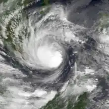
 Tess at peak intensity on November 5 | |
| Meteorological history | |
|---|---|
| Formed | November 1, 1988 |
| Dissipated | November 6, 1988 |
| Severe tropical storm | |
| 10-minute sustained (JMA) | |
| Highest winds | 110 km/h (70 mph) |
| Lowest pressure | 975 hPa (mbar); 28.79 inHg |
| Category 1-equivalent typhoon | |
| 1-minute sustained (SSHWS/JTWC) | |
| Highest winds | 120 km/h (75 mph) |
| Overall effects | |
| Fatalities | 123 total |
| Damage | $22.4 million |
| Areas affected | Philippines, Vietnam |
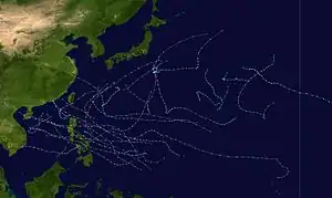
Part of the 1988 Pacific typhoon season | |
Tropical Storm Tess and its precursor disturbance brought extensive flooding to much of the central Philippines. In Cebu, eight people were killed, and many homes and bridges were destroyed. The province of Palawan, a geographically isolated island from the rest of the country, suffered severe damage due to mudslides and flooding. There, 75 people were confirmed to have died, and 600 others were later presumed to have perished. In the suburbs of the capital city of Manila, 3,000 people were forced to flee their homes due to rising floodwaters. In all, there were a total of 686 deaths in the country. Nationwide, 144,136 people were evacuated to shelter, and 86 homes were destroyed, with 430 others receiving damage. Damage in the country totaled $11.38 million (1988 USD). In addition to the impact on the Philippines, Tess killed 37 people and inflicted $11 million in damage in Vietnam.
Meteorological history

Tropical storm (39–73 mph, 63–118 km/h)
Category 1 (74–95 mph, 119–153 km/h)
Category 2 (96–110 mph, 154–177 km/h)
Category 3 (111–129 mph, 178–208 km/h)
Category 4 (130–156 mph, 209–251 km/h)
Category 5 (≥157 mph, ≥252 km/h)
Unknown
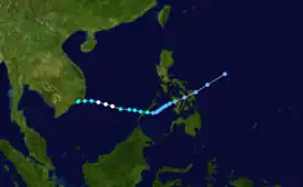
In what would later become the second of two tropical cyclones to form within the basin during November 1988,[1] an area of disturbed weather was first noted by the Joint Typhoon Warning Center (JTWC) early on November 1.[2] Six hours later, the Japan Meteorological Agency (JMA) started following the system.[3][nb 1] The same day, the Philippine Atmospheric, Geophysical and Astronomical Services Administration also started to track the storm and assigned it with the local name Welpring.[5] Over the next three days, the disturbance tracked southwest while embedded within the northeasterly flow of the winter monsoon. After passing through the Visayas island group and emerging into the open water of the Sulu Sea, the system began to increase in organization. At 17:30 UTC on November 3, the JTWC issued a Tropical Cyclone Formation Alert. At 00:00 UTC the next day, the JTWC classified the system as a tropical depression, citing satellite intensity estimates of 55 km/h (35 mph),[2] while the JMA upgraded it to tropical storm intensity.[6][nb 2] At this time, the tropical cyclone was centered 620 km (385 mi) south of Manila.[1]
Almost immediately after the upgrades, the storm's track shifted from southwestward to westward in response to a trough weakening to the north; this also weakened the pressure gradient between the trough and a nearby ridge starting on November 4. In turn, wind shear decreased and allowed the storm to intensify. Following an increase in satellite intensity estimates, the JTWC upgraded the depression into a tropical storm, and named it Tess, at 06:00 UTC. As the storm tracked over the South China Sea,[2] strengthening continued. On November 5, the JMA upgraded Tess into a severe tropical storm.[3] At midday, the JTWC estimated that Tess attained typhoon intensity,[6] which was also its maximum intensity of 120 km/h (75 mph).[2] At 18:00 UTC on November 5, the JMA reported that Tess attained winds of 115 km/h (70 mph) and a barometric pressure of 975 mbar (30 inHg), its peak intensities in terms of both winds and pressure.[3] Data from the JTWC suggests the storm weakened rapidly as it approached Vietnam.[6][1] At 00:00 UTC on November 6, the JTWC stopped tracking the system;[2] however, intensity estimates from the JMA had only decreased slightly during this time, and continued to classify Tess as a severe tropical storm.[3] Tess then moved across the Mekong River delta,[2] moving ashore midday about 240 km (150 mi) east-northeast of Ho Chi Minh City.[1] By early November 7, the JMA stopped tracking the system.[3]
Impact and aftermath
By moving across the central Philippines in its formative phases, Tess became the second tropical cyclone to impact the island group within two weeks;[8] the first was Typhoon Ruby.[9] At least nine people were killed in the provinces of Cebu and Bukidnon, where the storm also rendered 600 people homeless.[9] Eight of those deaths occurred in Cebu.[10] There, the storm brought flash flooding that destroyed numerous bridges[11] and homes.[12] Palawan Island, a rugged, sparsely populated island chain isolated from the rest of the country, sustained widespread destruction from Tess, primarily due to flooding and landslides. On the island, the town of Rizal sustained the worst damage from the storm. There, 23 fatalities occurred. The island's north-south coastal road was covered in 7.5 ft (2.3 m) of water. By November 10, 75 people were confirmed to have been killed throughout Palawan, with 600 others subsequently listed as missing by the Philippine Red Cross.[13] The missing were presumed dead by December 14.[14] In part because the water level was already 5.5 ft (1.7 m) above normal due to Ruby, Laguna Lake, situated on the southeastern side of the capital city of Manila, overflowed its banks.[15] This forced 3,000 people,[16] mainly in the suburbs of Pasig, Taguig and Pateros, to evacuate their homes.[17] Outside Palawan Island,[13] Tess only resulted in 11 fatalities only in the island chain, all due to flooding.[18]
Nationwide, the storm was blamed for 686 deaths.[13][14][18] Additionally, 144,136 people or 28,824 families were evacuated to shelters as a result of the flooding. A total of 86 homes were destroyed and 430 others were damaged.[19] Furthermore, damage to private property totaled $7.58 million (1988 USD). In addition, the storm caused $3.8 million in damage to agriculture. Overall, the nation suffered $11.38 million damage due to the cyclone.[20][nb 3]
Even though the storm had weakened drastically by this time, Tess killed 37 people in Vietnam,[1] destroyed thousands of homes,[21] and inflicted $11 million in damage.[1] Following Tess, Philippine President Corazon Aquino visited the provinces of Pangasinan and Pampanga, both situated to the north of Manila to tour damaged areas, distribute relief, aid and inaugurate an infrastructure project.[9] A mere few days after Tess, Typhoon Skip became the third cyclone to hit the archipelago in two weeks.[22]
Notes
- The Japan Meteorological Agency is the official Regional Specialized Meteorological Center for the western Pacific Ocean.[4]
- Wind estimates from the JMA and most other basins throughout the world are sustained over 10 minutes, while estimates from the United States-based Joint Typhoon Warning Center are sustained over 1 minute. 10-minute winds are about 1.14 times the amount of 1-minute winds.[7]
- All Philippine currencies are converted to United States Dollars using Philippines Measuring worth with an exchange rate of the year 1988.
References
- Meteorological Results: 1988 (PDF) (Report). Hong Kong Royal Observatory. 1989. Retrieved April 14, 2017.
- Joint Typhoon Warning Center; Naval Pacific Meteorology and Oceanography Center (1989). Annual Tropical Cyclone Report: 1988 (PDF) (Report). United States Navy, United States Air Force. Retrieved April 14, 2017.
- Japan Meteorological Agency (October 10, 1992). RSMC Best Track Data – 1980–1989 (Report). Archived from the original (.TXT) on December 5, 2014. Retrieved April 14, 2017.
- "Annual Report on Activities of the RSMC Tokyo – Typhoon Center 2000" (PDF). Japan Meteorological Agency. February 2001. p. 3. Retrieved April 14, 2017.
- Padua, Michael V. (November 6, 2008). PAGASA Tropical Cyclone Names 1963–1988 (Report). Typhoon 2000. Retrieved April 12, 2017.
- Knapp, Kenneth R.; Kruk, Michael C.; H. Levinson, David; J. Diamond, Howard; J. Neumann, Charles (2010). 1988 Tess (1988306N15130). The International Best Track Archive for Climate Stewardship (IBTrACS): Unifying tropical cyclone best track data (Report). Bulletin of the American Meteorological Society. Retrieved August 12, 2016.
- Christopher W Landsea; Hurricane Research Division (April 26, 2004). "Subject: D4) What does "maximum sustained wind" mean? How does it relate to gusts in tropical cyclones?". Frequently Asked Questions. National Oceanic and Atmospheric Administration's Atlantic Oceanographic and Meteorological Laboratory. Retrieved April 14, 2017.
- Reid, Robert H. (November 6, 1988). "Typhoon Skip Hits Philippines; Thousands Flee Homes". Associated Press. – via Lexis Nexis (subscription required)
- Del Mundo, Fernando (November 5, 1988). "International News". United Press International. – via Lexis Nexis (subscription required)
- "Another Typhoon Headed Toward Philippines". Associated Press. November 6, 1988.
- "Typhoon rushes toward central Philippines". United Press International. November 7, 1988. – via Lexis Nexis (subscription required)
- "Typhoon 'Skip' bearing down on Philippines". United Press International. November 6, 1988. – via Lexis Nexis (subscription required)
- "Death Toll From Three Typhoons Hits 670, 600 More Missing". Association Press. November 11, 1988. – via Lexis Nexis (subscription required)
- "Domestic News". Associated Press. December 14, 1988. – via Lexis Nexis (subscription required)
- H. Reid, Robert (November 6, 1988). "Storm Warning Posted For Manila As Typhoon Skip Nears". Associated Press. – via Lexis Nexis (subscription required)
- Arquiza, Yasmin (November 7, 1988). "Typhoon Hits Philippines With Winds Topping 100 Mph". Association Press. – via Lexis Nexis (subscription required)
- Reid, Robert H. (November 6, 1988). "Typhoon Skip Gains Strength As It Heads Towards Manila". Association Press. – via Lexis Nexis (subscription required)
- Reid, Robert H. (November 7, 1988). "Storm Sweeps Out To Sea After Killing At Least 22". Associated Press. – via Lexis Nexis (subscription required)
- Destructive Typhoons 1970-2003 (Report). National Disaster Coordinating Council. November 9, 2004. Archived from the original on November 9, 2004. Retrieved April 14, 2017.
- Destructive Typhoons 1970-2003 (Report). National Disaster Coordinating Council. November 9, 2004. Archived from the original on March 15, 2005. Retrieved April 14, 2017.
- Del Mundo, Fernando (November 10, 1988). "Typhoon Skip leaves 191 dead in Philippines". United Press International. – via Lexis Nexis (subscription required)
- "Typhoon Skip Leaves At Least 24 People Dead In Philippines". Associated Press. November 8, 1988. – via Lexis Nexis (subscription required)
External links
- Japan Meteorological Agency
- Joint Typhoon Warning Center Archived 2015-08-09 at the Wayback Machine
