Tregear, New South Wales
Tregear is a suburb of Sydney, in the state of New South Wales, Australia. Tregear is 36 kilometres (22 mi) west of the Sydney central business district, in the local government area of the City of Blacktown and is part of the Greater Western Sydney region.
| Tregear Sydney, New South Wales | |||||||||||||||
|---|---|---|---|---|---|---|---|---|---|---|---|---|---|---|---|
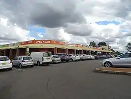
 Tregear shops | |||||||||||||||
 Tregear | |||||||||||||||
| Coordinates | 33°45′0″S 150°47′40″E | ||||||||||||||
| Population | 3,916 (2011 census)[1] | ||||||||||||||
| • Density | 24.02/km2 (62.22/sq mi) | ||||||||||||||
| Postcode(s) | 2770 | ||||||||||||||
| Elevation | 56 m (184 ft) | ||||||||||||||
| Area | 163 km2 (62.9 sq mi) | ||||||||||||||
| Location | 46 km (29 mi) west of Sydney CBD | ||||||||||||||
| LGA(s) | City of Blacktown | ||||||||||||||
| State electorate(s) | Mount Druitt | ||||||||||||||
| Federal division(s) | Chifley | ||||||||||||||
| |||||||||||||||
Tregear has privately owned housing, Department of Housing homes and a small shopping centre. Which is popular.
At the 2011 census, Tregear had 3,916 people listing Tregear as their usual residence. There were slightly more women than men, more than 10% were Indigenous and almost 30% were born overseas.[1] The land area amounts to 163 hectares.[2]
History
Tregear was the name of a homestead built in the area which at one stage was owned by John King-Lethbridge, son of Robert Copland Lethbridge and Mary King. It was named after the Lethbridge family's estate in Cornwall, England.[3] The land was held by Lethbridge family until 1942 when it was taken over by the RAAF and then sold in 1951.
Commercial area
Tregear has a small shopping centre which consists of an IGA supermarket, chemist, post office, newsagent, kebab shop, take-away shop and a doctor. There is a small car park out the front of the shopping complex, with a public pay phone as well. It is a 10-minute drive from Westfield Mount Druitt Shopping Centre. There are only two sets of traffic lights in Tregear. There are 3 GP offices in Tregear.
Schools
Tregear has a local public primary school and a preschool which also is a church.
Recreation
Tregear Reserve covers a vast span of the suburb and allows off-leash dog-walking.[4]
References
- Australian Bureau of Statistics (31 October 2012). "Tregear (State Suburb)". 2011 Census QuickStats. Retrieved 26 April 2015.
- Tregear Demographics, City of Blacktown. Retrieved 12 January 2008.
- "Tregear". Geographical Names Register (GNR) of NSW. Geographical Names Board of New South Wales. Retrieved 4 August 2013.
- Off Leash Dog Walking, Tregear Reserve Archived 16 January 2008 at the Wayback Machine, City of Blacktown. Retrieved 10 January 2008.