Tomaszów County, Lublin Voivodeship
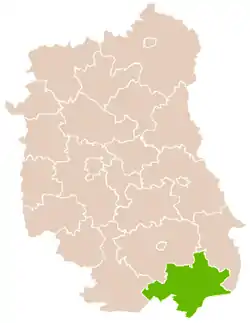
Tomaszów County (Polish: powiat tomaszowski) is a unit of territorial administration and local government (powiat) in Lublin Voivodeship, eastern Poland, on the border with Ukraine. It was established on January 1, 1999, as a result of the Polish local government reforms passed in 1998. Its administrative seat and largest town is Tomaszów Lubelski, which lies 107 kilometres (66 mi) south-east of the regional capital Lublin. The only other towns in the county are Tyszowce, lying 28 km (17 mi) north-east of Tomaszów, and Łaszczów, lying 25 km (16 mi) east of Tomaszów.
Tomaszów County
Powiat tomaszowski | |
|---|---|
 Flag  Coat of arms | |
 Location within the voivodeship | |
| Coordinates (Tomaszów Lubelski): 50°27′N 23°25′E | |
| Country | |
| Voivodeship | Lublin |
| Seat | Tomaszów Lubelski |
| Gminas | |
| Area | |
| • Total | 1,487.1 km2 (574.2 sq mi) |
| Population (2019) | |
| • Total | 80,701 |
| • Density | 54/km2 (140/sq mi) |
| • Urban | 23,301 |
| • Rural | 57,400 |
| Car plates | LTM |
| Website | http://www.powiat-tomaszowski.com.pl |
The county covers an area of 1,487.1 square kilometres (574.2 sq mi). As of 2019, its total population was 80,701, including a population of 19,050 in Tomaszów Lubelski, 2,112 in Tyszowce, 2,139 in Łaszczów, and a rural population of 57,400.[1]
Neighbouring counties
Tomaszów County is bordered by Lubaczów County to the south-west, Biłgoraj County to the west, Zamość County to the north and Hrubieszów County to the north-east. It also borders Ukraine to the south-east.
Administrative division
The county is subdivided into 13 gminas (one urban, two urban-rural and 10 rural). These are listed in the following table, in descending order of population.
| Gmina | Type | Area (km2) |
Population (2019) |
Seat |
|---|---|---|---|---|
| Tomaszów Lubelski | urban | 13.3 | 19,050 | |
| Gmina Tomaszów Lubelski | rural | 170.8 | 11,431 | Tomaszów Lubelski[lower-alpha 1] |
| Gmina Susiec | rural | 190.5 | 7,458 | Susiec |
| Gmina Łaszczów | urban-rural | 128.2 | 6,010 | Łaszczów |
| Gmina Tyszowce | urban-rural | 129.5 | 5,548 | Tyszowce |
| Gmina Rachanie | rural | 94.1 | 5,099 | Rachanie |
| Gmina Ulhówek | rural | 146.6 | 4,580 | Ulhówek |
| Gmina Telatyn | rural | 109.7 | 3,950 | Telatyn |
| Gmina Tarnawatka | rural | 82.7 | 3,922 | Tarnawatka |
| Gmina Lubycza Królewska | rural | 208.9 | 3,732 | Lubycza Królewska |
| Gmina Jarczów | rural | 107.5 | 3,391 | Jarczów |
| Gmina Bełżec | rural | 33.5 | 3,301 | Bełżec |
| Gmina Krynice | rural | 73.6 | 3,229 | Krynice |
- seat not part of the gmina
See also
References
- GUS. "Population. Size and structure and vital statistics in Poland by territorial division in 2019. As of 30th June". stat.gov.pl. Retrieved 2020-09-14.
