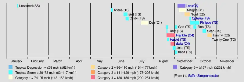
Timeline of the 2023 Atlantic hurricane season
The 2023 Atlantic hurricane season is the current hurricane season, the annual period of tropical cyclogenesis in the Atlantic Ocean in the Northern Hemisphere. The season officially began on June 1, 2023, and will end on November 30, 2023. These dates, adopted by convention, historically describe the period in each year when most subtropical or tropical cyclones form in the Atlantic.[1] However, tropical cyclone formation is possible at any time of the year, as was the case this season, when an unnamed subtropical storm formed on January 16.[2]
| Timeline of the 2023 Atlantic hurricane season | |||||
|---|---|---|---|---|---|
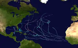 Season summary map | |||||
| Season boundaries | |||||
| First system formed | January 16, 2023 | ||||
| Last system dissipated | Season ongoing | ||||
| Strongest system | |||||
| Name | Lee | ||||
| Maximum winds | 165 mph (270 km/h) (1-minute sustained) | ||||
| Lowest pressure | 926 mbar (hPa; 27.35 inHg) | ||||
| Longest lasting system | |||||
| Name | Philippe | ||||
| Duration | 12.75 days | ||||
| |||||
This timeline documents tropical cyclone formations, strengthening, weakening, landfalls, extratropical transitions, and dissipations during the season. It includes information that was not released throughout the season, meaning that data from post-storm reviews by the National Hurricane Center, such as a storm that was not initially warned upon, has been included.
By convention, meteorologists use one time zone when issuing forecasts and making observations: Coordinated Universal Time (UTC), and also use the 24-hour clock (where 00:00 = midnight UTC).[3] The National Hurricane Center uses both UTC and the time zone where the center of the tropical cyclone is currently located. The time zones utilized (east to west) are: Greenwich, Cape Verde, Atlantic, Eastern, and Central.[4] In this timeline, all information is listed by UTC first, with the respective regional time zone included in parentheses. Additionally, figures for maximum sustained winds and position estimates are rounded to the nearest 5 units (knots, miles, or kilometers), following National Hurricane Center practice. Direct wind observations are rounded to the nearest whole number. Atmospheric pressures are listed to the nearest millibar and nearest hundredth of an inch of mercury.
Timeline
January
January 16

- 12:00 UTC (8:00 a.m. AST) at 37.1°N 66.1°W – A subtropical storm forms about 345 mi (555 km) southeast of Nantucket, Massachusetts.[nb 1][5]
January 17
- 00:00 UTC (8:00 p.m. AST, January 16) at 39.8°N 61.6°W – The unnamed subtropical storm reaches peak intensity with maximum sustained winds of 70 mph (110 km/h) and a minimum central pressure of 976 mbar (28.82 inHg), about 345 mi (555 km) south-southeast of Halifax, Nova Scotia.[5]
- 12:45 UTC (8:45 a.m. AST) at 45.9°N 60.0°W – The unnamed subtropical storm makes landfall at Louisbourg, Nova Scotia, with sustained winds of 50 mph (85 km/h).[5]
- 18:00 UTC (2:00 p.m. AST) at 48.4°N 60.2°W – The unnamed subtropical storm transitions to a post-tropical low south of the coast of far eastern Quebec, and subsequently dissipates.[5]
June
June 1
- The Atlantic hurricane season officially begins.[1]
- 12:00 UTC (7:00 a.m. CDT) at 27.7°N 86.2°W – Tropical Depression Two forms off the western coast of Florida.[6]
June 2
- 18:00 UTC (1:00 p.m. CDT) at 27.3°N 86.4°W – Tropical Depression Two strengthens into Tropical Storm Arlene.[6]
June 3
- 00:00 UTC (7:00 p.m. CDT, June 2) at 25.9°N 85.7°W – Tropical Storm Arlene reaches peak intensity with maximum sustained winds of 40 mph (65 km/h) and a minimum central pressure of 998 mbar (29.47 inHg).[6]
- 06:00 UTC (1:00 a.m. CDT) at 25.0°N 85.6°W – Tropical Storm Arlene weakens to a tropical depression.[6]
- 12:00 UTC (8:00 a.m. EDT) at 24.4°N 85.3°W – Tropical Depression Arlene degenerates into a remnant low, and subsequently dissipates.[6]
June 19
- 15:00 UTC (11:00 a.m. AST) at 11.0°N 40.3°W – Tropical Depression Three forms from a tropical wave about 1,425 mi (2,295 km) east of the southern Windward Islands.[7]
- 21:00 UTC (5:00 p.m. AST) at 11.3°N 42.2°W – Tropical Depression Three strengthens into Tropical Storm Bret about 1,295 mi (2,085 km) east of the southern Windward Islands.[8]
June 22
- 00:00 UTC (8:00 p.m. AST, June 21) at 10.4°N 39.9°W – Tropical Depression Four forms from a tropical wave over the central tropical Atlantic.[9]
- 06:00 UTC (2:00 a.m. AST) at 13.5°N 55.8°W – Tropical Storm Bret reaches peak intensity with maximum sustained winds of 70 mph (115 km/h) and a minimum central pressure of 996 mbar (29.41 inHg), about 250 mi (400 km) east of Barbados.[10]
June 23
- 00:00 UTC (8:00 p.m. AST, June 22) at 11.5°N 44.8°W – Tropical Depression Four strengthens into Tropical Storm Cindy east of the Lesser Antilles.[9]
June 24
- 06:00 UTC (2:00 a.m. AST) at 14.6°N 51.2°W – Tropical Storm Cindy reaches peak intensity with maximum sustained winds of 50 mph (80 km/h) and a minimum central pressure of 1004 mbar (29.65 inHg).[9]
- 21:00 UTC (5:00 p.m. EDT) at 13.1°N 73.8°W – Tropical Storm Bret opens into a trough about 160 mi (255 km) west-northwest of the northern tip of the Guajira Peninsula of Colombia.[11]
June 26
- 03:00 UTC (11:00 p.m. AST, June 25) at 22.8°N 60.0°W – Tropical Storm Cindy degenerates to an open wave about 375 mi (605 km) north-northeast of the Northern Leeward Islands.[nb 2][13]
July
July 14
- 09:00 UTC (5:00 a.m. AST) at 32.9°N 46.8°W – Subtropical Storm Don forms from an area of low pressure about 1,165 mi (1,875 km) west-southwest of the Azores.[14]
July 16
- 15:00 UTC (11:00 a.m. AST) at 39.0°N 48.1°W – Subtropical Storm Don weakens to a subtropical depression about 1,140 mi (1,835 km) west of the Azores.[15]
July 17

- 15:00 UTC (3:00 p.m. GMT) at 38.6°N 42.9°W – Subtropical Depression Don transitions to a tropical depression about 860 mi (1,385 km) west of the Azores.[16]
July 18
- 03:00 UTC (3:00 a.m. GMT) at 37.4°N 40.4°W – Tropical Depression Don strengthens into a tropical storm about 735 mi (1,185 km) west of the Azores.[17]
July 22
- 21:00 UTC (5:00 p.m. AST) at 40.1°N 50.0°W – Tropical Storm Don strengthens into a Category 1 hurricane and simultaneously reaches peak intensity with maximum sustained winds of 75 mph (120 km/h) and a minimum central pressure of 988 mbar (29.18 inHg), about 480 miles (770 km) south-southeast of Cape Race, Newfoundland.[18]
July 23
- 09:00 UTC (5:00 a.m. AST) at 42.6°N 48.9°W – Hurricane Don weakens to a tropical storm about 350 mi (565 km) southeast of Cape Race.[19]
July 24
- 15:00 UTC (3:00 p.m. GMT) at 47.6°N 40.7°W – Tropical Storm Don transitions to a post-tropical cyclone about 585 mi (940 km) east of Cape Race.[20]
August
August 19
- 21:00 UTC (5:00 p.m. AST) at 16.7°N 50.2°W – Tropical Depression Six forms from a tropical wave about 855 mi (1,375 km) east of the northern Leeward Islands.[21]
August 20
- 15:00 UTC (11:00 a.m. AST) at 19.5°N 38.8°W – Tropical Storm Emily forms from a tropical disturbance and simultaneously reaches peak intensity with maximum sustained winds of 50 mph (85 km/h) and a minimum central pressure of 1001 mbar (29.56 inHg), about 1,000 mi (1,610 km) west-northwest of Cabo Verde.[22]
- 21:00 UTC (5:00 p.m. AST) at 14.6°N 67.1°W – Tropical Storm Franklin forms from an area of low pressure about 270 mi (435 km) south-southeast of Isla Saona, Dominican Republic.[23]
August 21
- 04:00 UTC (12:00 a.m. AST) at 16.7°N 55.9°W – Tropical Depression Six strengthens into Tropical Storm Gert about 485 mi (780 km) east of the northern Leeward Islands.[24]
- 15:00 UTC (11:00 a.m. AST) at 21.1°N 41.9°W – Tropical Storm Emily degenerates to a remnant low about 1,225 mi (1,970 km) west-northwest of Cabo Verde.[nb 3][26]
- 21:00 UTC (4:00 p.m. AST) at 25.2°N 91.6°W – Tropical Depression Nine forms about 375 mi (605 km) east-southeast of Port Mansfield, Texas.[nb 4][28]
- 21:00 UTC (5:00 p.m. AST) at 17.1°N 57.5°W – Tropical Storm Gert weakens to a tropical depression about 375 mi (605 km) east of the northern Leeward Islands.[29]
August 22
- 06:00 UTC (1:00 a.m. CDT) at 25.8°N 94.4°W – Tropical Depression Nine strengthens into Tropical Storm Harold about 195 mi (315 km) east-southeast of Port Mansfield.[30]
- 15:00 UTC (10:00 a.m. CDT) at 27.1°N 97.4°W – Tropical Storm Harold reaches peak intensity with maximum sustained winds of 50 mph (85 km/h) and a minimum central pressure of 996 mbar (29.41 inHg), and simultaneously makes landfall at Padre Island, Texas, about 35 mi (55 km) north of Port Mansfield.[31][32]
- 15:00 UTC (11:00 a.m. AST) at 17.4°N 59.7°W – Tropical Depression Gert degenerates to a remnant low about 230 mi (370 km) east-southeast of the northern Leeward Islands.[33]
- 21:00 UTC (4:00 p.m. CDT) at 27.6°N 99.3°W – Tropical Storm Harold weakens to a tropical depression about 15 mi (25 km) east of Laredo, Texas.[34]
August 23
- 12:00 UTC (8:00 a.m. EDT) at 17.9°N 71.2°W – Tropical Storm Franklin makes landfall with sustained winds of 50 mph (85 km/h), about 25 miles (40 km) south-southwest of Barahona, Dominican Republic.[35]
- 15:00 UTC (10:00 a.m. CDT) at 30.4°N 104.4°W – Tropical Depression Harold degenerates to a remnant low about 155 mi (250 km) southeast of El Paso, Texas.[36]
August 26
- 15:00 UTC (11:00 a.m. AST) at 23.5°N 66.7°W – Tropical Storm Franklin strengthens into a Category 1 hurricane about 315 mi (505 km) east-northeast of Grand Turk Island.[37]
- 21:00 UTC (4:00 p.m. CDT) at 21.1°N 86.1°W – Tropical Depression Ten forms about 65 mi (105 km) northeast of Cozumel, Quintana Roo.[38]
August 27
- 15:00 UTC (11:00 a.m. AST) at 25.1°N 69.3°W – Hurricane Franklin intensifies to Category 2 strength about 275 mi (445 km) north-northeast of Grand Turk Island.[39]
- 15:15 UTC (10:15 a.m. CDT) at 19.9°N 85.8°W – Tropical Depression Ten strengthens into Tropical Storm Idalia about 80 mi (130 km) east-southeast of Cozumel.[40]
August 28
- 09:00 UTC (5:00 a.m. EDT) at 27.2°N 70.8°W – Hurricane Franklin intensifies to Category 3 strength about 395 mi (635 km) north of Grand Turk Island.[41]
- 11:35 UTC (7:35 a.m. EDT) at 27.4°N 70.8°W – Hurricane Franklin intensifies to Category 4 strength about 405 mi (650 km) north of Grand Turk Island.[42]
August 29

- 00:00 UTC (8:00 p.m. EDT, August 28) at 29.0°N 71.1°W – Hurricane Franklin reaches peak intensity with maximum sustained winds of 150 mph (240 km/h) and a minimum central pressure of 926 mbar (27.34 inHg), about 440 mi (710 km) west-southwest of Bermuda.[43]
- 09:00 UTC (4:00 a.m. CDT) at 22.1°N 85.0°W – Tropical Storm Idalia strengthens into a Category 1 hurricane about 85 mi (135 km) north of the western tip of Cuba.[44]
- 15:00 UTC (11:00 a.m. AST) at 27.9°N 51.4°W – Tropical Depression Eleven forms from an area of low pressure about 855 mi (1,375 km) east-southeast of Bermuda.[45]
- 18:00 UTC (2:00 p.m. EDT) at 31.0°N 70.2°W – Hurricane Franklin weakens to Category 3 strength about 330 mi (530 km) west-southwest of Bermuda.[46]
- 21:00 UTC (5:00 p.m. EDT) at 26.1°N 84.8°W – Hurricane Idalia intensifies to Category 2 strength about 195 mi (315 km) southwest of Tampa, Florida.[47]
August 30
- 06:00 UTC (2:00 a.m. EDT) at 28.3°N 84.5°W – Hurricane Idalia intensifies to Category 3 strength about 100 mi (160 km) southwest of Cedar Key, Florida.[48]
- 09:00 UTC (5:00 a.m. EDT) at 29.1°N 84.1°W – Hurricane Idalia intensifies to Category 4 strength and simultaneously reaches peak intensity with maximum sustained winds of 130 mph (215 km/h) and a minimum central pressure of 940 mbar (27.76 inHg), about 60 mi (95 km) west of Cedar Key.[49]
- 09:00 UTC (5:00 a.m. AST) at 33.0°N 68.2°W – Hurricane Franklin weakens to Category 2 strength about 205 mi (330 km) west-northwest of Bermuda.[50]
- 11:00 UTC (7:00 a.m. EDT) at 29.6°N 83.8°W – Hurricane Idalia weakens to Category 3 strength about 55 mi (90 km) northwest of Cedar Key.[51]
- 11:45 UTC (7:45 a.m. EDT) at 29.8°N 83.6°W – Hurricane Idalia makes landfall with sustained winds of 125 mph (205 km/h), about 20 mi (30 km) south of Perry, Florida.[52]
- 13:00 UTC (9:00 a.m. EDT) at 30.2°N 83.5°W – Hurricane Idalia weakens to Category 2 strength about 20 mi (30 km) south-southwest of Madison, Florida.[53]
- 15:00 UTC (11:00 a.m. EDT) at 30.6°N 83.2°W – Hurricane Idalia weakens to Category 1 strength about 15 mi (25 km) south-southeast of Valdosta, Georgia.[54]
- 21:00 UTC (5:00 p.m. EDT) at 32.2°N 81.7°W – Hurricane Idalia weakens to a tropical storm about 40 mi (65 km) west of Savannah, Georgia.[55]
August 31
- 09:00 UTC (5:00 a.m. AST) at 28.8°N 52.2°W – Tropical Depression Eleven strengthens into Tropical Storm Jose about 785 mi (1,265 km) east-southeast of Bermuda.[56]
- 21:00 UTC (5:00 p.m. AST) at 36.0°N 60.1°W – Hurricane Franklin weakens to Category 1 strength about 370 mi (595 km) northeast of Bermuda.[57]
- 21:00 UTC (5:00 p.m. EDT) at 33.5°N 73.5°W – Tropical Storm Idalia transitions to an extratropical cyclone about 65 mi (105 km) southeast of Cape Hatteras, North Carolina.[58]
September
September 1

- 09:00 UTC (5:00 a.m. AST) at 28.7°N 55.0°W – Remnants of Gert regenerate into a tropical depression about 635 mi (1,020 km) east-southeast of Bermuda.[59]
- 09:00 UTC (5:00 a.m. AST) at 33.9°N 52.0°W – Tropical Storm Jose reaches peak intensity with maximum sustained winds of 60 mph (95 km/h) and a minimum central pressure of 997 mbar (29.44 inHg), about 750 mi (1,205 km) east-northeast of Bermuda.[60]
- 15:00 UTC (2:00 p.m. CVT) at 19.6°N 28.3°W – Tropical Depression Twelve forms from an area of low pressure about 375 mi (605 km) northwest of Cabo Verde.[61]
- 21:00 UTC (5:00 p.m. AST) at 27.8°N 54.4°W – Tropical Depression Gert re-strengthens to a tropical storm about 695 mi (1,120 km) east-southeast of Bermuda.[62]
- 21:00 UTC (5:00 p.m. AST) at 39.5°N 53.8°W – Hurricane Franklin transitions to an extratropical cyclone about 790 mi (1,270 km) northeast of Bermuda.[nb 5][64]
September 2
- 03:00 UTC (11:00 p.m. AST, September 1) at 42.1°N 47.4°W – Tropical Storm Jose is absorbed into Post‑Tropical Cyclone Franklin about 1,170 mi (1,885 km) northeast of Bermuda.[65]
- 09:00 UTC (8:00 a.m. CVT) at 22.7°N 29.4°W – Tropical Depression Twelve strengthens into Tropical Storm Katia about 580 mi (935 km) northwest of Cabo Verde.[66]
- 21:00 UTC (5:00 p.m. AST) at 25.0°N 30.5°W – Tropical Storm Katia reaches peak intensity with maximum sustained winds of 60 mph (95 km/h) and a minimum central pressure of 998 mbar (29.47 inHg), about 750 mi (1,205 km) north-northwest of Cabo Verde.[67]
September 3
- 15:00 UTC (11:00 a.m. AST) at 31.2°N 51.9°W – Tropical Storm Gert reaches peak intensity with maximum sustained winds of 60 mph (95 km/h) and a minimum central pressure of 997 mbar (29.44 inHg), about 760 mi (1,225 km) east of Bermuda.[68]
September 4
- 03:00 UTC (3:00 a.m. GMT) at 27.1°N 33.4°W – Tropical Storm Katia weakens to a tropical depression about 975 mi (1,570 km) northwest of Cabo Verde.[69]
- 15:00 UTC (11:00 a.m. AST) at 40.5°N 51.0°W – Tropical Storm Gert dissipates about 950 mi (1,530 km) northeast of Bermuda.[70]
- 21:00 UTC (9:00 p.m. GMT) at 28.0°N 34.4°W – Tropical Depression Katia degenerates to a remnant low about 1,060 mi (1,705 km) northwest of Cabo Verde.[71]
September 5
- 15:00 UTC (11:00 a.m. AST) at 12.5°N 40.2°W – Tropical Depression Thirteen forms from a tropical wave about 1,425 mi (2,295 km) east of the Lesser Antilles.[72]
- 21:00 UTC (5:00 p.m. AST) at 13.2°N 41.8°W – Tropical Depression Thirteen strengthens into Tropical Storm Lee about 1,315 mi (2,115 km) east of the Lesser Antilles.[73]
September 6
- 21:00 UTC (5:00 p.m. AST) at 14.9°N 46.4°W – Tropical Storm Lee strengthens into a Category 1 hurricane about 1,130 mi (1,820 km) east of the northern Leeward Islands.[74]
September 7
- 15:00 UTC (11:00 a.m. AST) at 16.4°N 50.0°W – Hurricane Lee intensifies to Category 2 strength about 870 mi (1,400 km) northeast of the northern Leeward Islands.[75]
- 15:00 UTC (2:00 p.m. CVT) at 15.7°N 26.4°W – Tropical Depression Fourteen forms from a tropical wave about 160 mi (255 km) west of Cabo Verde.[76]
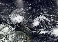
- 21:00 UTC (5:00 p.m. AST) at 16.9°N 51.3°W – Hurricane Lee rapidly intensifies to Category 4 strength about 780 mi (1,255 km) east of the northern Leeward Islands.[77]
- 21:00 UTC (8:00 p.m. CVT) at 16.8°N 28.3°W – Tropical Depression Fourteen strengthens into Tropical Storm Margot about 290 mi (465 km) west-northwest of Cabo Verde.[78]
September 8
.jpg.webp)
- 03:00 UTC (11:00 p.m. AST, September 7) at 17.3°N 52.4°W – Hurricane Lee intensifies to Category 5 strength about 705 mi (1,135 km) east of the northern Leeward Islands.[79]
- 09:00 UTC (5:00 a.m. AST) at 17.8°N 53.5°W – Hurricane Lee reaches peak intensity with maximum sustained winds of 165 mph (270 km/h) and a minimum central pressure of 926 mbar (27.34 inHg), about 630 mi (1,015 km) east of the northern Leeward Islands.[80]
- 15:00 UTC (11:00 a.m. AST) at 18.2°N 54.5°W – Hurricane Lee weakens to Category 4 strength about 565 mi (910 km) east of the northern Leeward Islands.[81]
September 9
- 03:00 UTC (11:00 p.m. AST, September 8) at 19.3°N 56.5°W – Hurricane Lee weakens to Category 3 strength about 440 mi (710 km) east of the northern Leeward Islands.[82]
September 10
- 03:00 UTC (11:00 p.m. AST, September 9) at 21.0°N 59.9°W – Hurricane Lee weakens to Category 2 strength about 285 mi (460 km) northeast of the northern Leeward Islands.[83]
- 21:00 UTC (5:00 p.m. AST) at 22.1°N 61.7°W – Hurricane Lee re-intensifies to Category 3 strength and simultaneously reaches a secondary peak with maximum sustained winds of 120 mph (195 km/h) about 285 mi (460 km) north-northeast of the northern Leeward Islands.[84]
September 11
- 21:00 UTC (9:00 p.m. GMT) at 27.0°N 39.8°W – Tropical Storm Margot strengthens into a Category 1 hurricane about 1,265 mi (2,035 km) northwest of Cabo Verde.[85]
September 13
- 15:00 UTC (3:00 p.m. GMT) at 34.1°N 40.4°W – Hurricane Margot reaches peak intensity with maximum sustained winds of 90 mph (150 km/h) and a minimum central pressure of 970 mbar (28.64 inHg), about 795 mi (1,280 km) west-southwest of the Azores.[86]
- 18:00 UTC (2:00 p.m. AST) at 26.8°N 67.5°W – Hurricane Lee weakens to Category 2 strength about 420 mi (675 km) south-southwest of Bermuda.[87]
September 14
- 15:00 UTC (11:00 a.m. AST) at 30.4°N 68.3°W – Hurricane Lee weakens to Category 1 strength about 245 mi (395 km) west-southwest of Bermuda.[88]
September 15
- 09:00 UTC (9:00 a.m. GMT) at 36.7°N 38.6°W – Hurricane Margot weakens to a tropical storm about 645 mi (1,040 km) west of the Azores.[89]
- 15:00 UTC (11:00 a.m. AST) at 14.4°N 43.8°W – Tropical Depression Fifteen forms about 1,170 mi (1,885 km) east of the Lesser Antilles.[90]
September 16
- 09:00 UTC (5:00 a.m. AST) at 41.8°N 66.0°W – Hurricane Lee transitions to an extratropical cyclone about 230 mi (370 km) south-southwest of Halifax, Nova Scotia.[nb 6][93]
September 17
- 03:00 UTC (11:00 p.m. AST, September 16) at 22.0°N 48.0°W – Tropical Depression Fifteen strengthens into Tropical Storm Nigel about 980 mi (1,575 km) east-northeast of the Lesser Antilles.[94]
- 15:00 UTC (3:00 p.m. GMT) at 34.6°N 42.4°W – Tropical Storm Margot transitions to a post-tropical cyclone about 885 mi (1,425 km) west of the Azores.[95]
September 18
- 09:00 UTC (5:00 a.m. AST) at 26.5°N 50.7°W – Tropical Storm Nigel strengthens into a Category 1 hurricane about 935 mi (1,505 km) east-southeast of Bermuda.[96]
September 19

- 21:00 UTC (5:00 p.m. AST) at 31.8°N 54.7°W – Hurricane Nigel intensifies to Category 2 strength about 590 mi (950 km) east of Bermuda.[97]
September 20
- 03:00 UTC (11:00 p.m. AST, September 19) at 33.2°N 54.7°W – Hurricane Nigel reaches peak intensity with maximum sustained winds of 100 mph (155 km/h) and a minimum central pressure of 971 mbar (28.67 inHg), about 590 mi (950 km) east of Bermuda.[98]
- 15:00 UTC (11:00 a.m. AST) at 36.1°N 54.4°W – Hurricane Nigel weakens to Category 1 strength about 650 mi (1,045 km) east-northeast of Bermuda.[99]
September 22
- 09:00 UTC (9:00 a.m. GMT) at 46.3°N 32.6°W – Hurricane Nigel transitions to an extratropical cyclone about 640 mi (1,030 km) north-northwest of the Azores.[100]
- 18:00 UTC (2:00 p.m. EDT) at 32.7°N 76.0°W – Tropical Storm Ophelia forms from a non-tropical area of low pressure about 150 mi (240 km) southeast of Cape Fear, North Carolina.[nb 7][102]
September 23
- 09:00 UTC (5:00 a.m. EDT) at 34.3°N 76.9°W – Tropical Storm Ophelia reaches peak intensity with maximum sustained winds of 70 mph (110 km/h) and a minimum central pressure of 981 mbar (28.97 inHg), about 25 mi (40 km) southwest of Cape Lookout, North Carolina.[103]
- 10:15 UTC (6:15 a.m. EDT) at 34.7°N 77.0°W – Tropical Storm Ophelia makes landfall near Emerald Isle, North Carolina with sustained winds of 70 mph (110 km/h), about 25 mi (40 km) west-northwest of Cape Lookout.[104]
- 15:00 UTC (11:00 a.m. AST) at 15.6°N 38.8°W – Tropical Depression Seventeen forms about 985 mi (1,585 km) west of Cape Verde.[105]
- 21:00 UTC (5:00 p.m. AST) at 15.6°N 39.7°W – Tropical Depression Seventeen strengthens into Tropical Storm Philippe about 1,045 mi (1,680 km) west of Cabo Verde.[106]
September 24
- 00:00 UTC (8:00 p.m. EDT, September 23) at 37.0°N 77.6°W – Tropical Storm Ophelia weakens to a tropical depression about 40 mi (65 km) south-southwest of Richmond, Virginia.[107]
- 03:00 UTC (11:00 p.m. EDT, September 23) at 37.1°N 77.6°W – Tropical Depression Ophelia degenerates to a remnant low about 30 mi (50 km) south-southwest of Richmond, Virginia.[108]
September 27
- 15:00 UTC (11:00 a.m. AST) at 17.5°N 53.7°W – Tropical Storm Philippe reaches peak intensity with maximum sustained winds of 50 mph (85 km/h) and a minimum central pressure of 998 mbar (29.47 inHg), about 620 mi (1,000 km) east of the northern Leeward Islands.[109]
September 28
- 15:00 UTC (11:00 a.m. AST) at 17.4°N 45.0°W – Tropical Storm Rina forms about 1,190 mi (1,915 km) east of the northern Leeward Islands.[110]
September 30

- 03:00 UTC (11:00 p.m. AST, September 29) at 20.4°N 48.8°W – Tropical Storm Rina reaches peak intensity with maximum sustained winds of 50 mph (85 km/h) and a minimum central pressure of 999 mbar (29.50 inHg), about 945 mi (1,520 km) east-northeast of the northern Leeward Islands.[111]
October
October 1
- 21:00 UTC (5:00 p.m. AST) at 26.2°N 55.5°W – Tropical Storm Rina weakens to a tropical depression about 735 mi (1,185 km) northeast of the northern Leeward Islands.[112]
October 2
- 03:00 UTC (11:00 p.m. AST, October 1) at 27.1°N 55.4°W – Tropical Depression Rina degerates into a remnant low about 1,265 mi (2,035 km) northeast of the northern Leeward Islands.[113]
- 22:00 UTC (6:00 p.m. AST) at 17.7°N 61.8°W – Tropical Storm Philippe makes landfall on Barbuda with sustained winds of 50 mph (85 km/h), about 40 mi (65 km) north of Antigua.[114]
October 6
- 15:00 UTC (11:00 a.m. AST) at 30.7°N 64.6°W – Tropical Storm Philippe transitions to a post-tropical cyclone about 110 mi (175 km) south of Bermuda.[115]
October 11
- 03:00 UTC (11:00 p.m. AST, October 10) at 9.7°N 32.0°W – Tropical Depression Nineteen forms about 690 mi (1,110 km) southwest of Cabo Verde.[116]
- 09:00 UTC (5:00 a.m. AST) at 10.3°N 33.1°W – Tropical Depression Nineteen strengthens into Tropical Storm Sean about 725 mi (1,165 km) west-southwest of Cabo Verde.[117]
October 12
- 03:00 UTC (11:00 p.m. AST, October 11) at 12.0°N 36.2°W – Tropical Storm Sean weakens to a tropical depression about 860 mi (1,385 km) west-southwest of Cabo Verde.[118]
- 15:00 UTC (11:00 a.m. AST) at 13.1°N 37.2°W – Tropical Depression Sean re-strengthens to a tropical storm about 905 mi (1,455 km) west of Cabo Verde.[119]
October 13
- 09:00 UTC (5:00 a.m. AST) at 14.3°N 40.5°W – Tropical Storm Sean reaches peak intensity with maximum sustained winds of 45 mph (75 km/h) and a minimum central pressure of 1004 mbar (29.65 inHg), about 1,105 mi (1,780 km) west of Cabo Verde.[120]
October 14
- 15:00 UTC (11:00 a.m. AST) at 16.0°N 44.2°W – Tropical Storm Sean weakens to a tropical depression about 860 mi (1,385 km) east of the northern Leeward Islands.[121]
October 16
- 03:00 UTC (11:00 p.m. AST, October 15) at 18.2°N 44.2°W – Tropical Depression Sean degenerates into a remnant low about 905 mi (1,455 km) east of the northern Leeward Islands.[122]
October 18
- 21:00 UTC (5:00 p.m. AST) at 13.0°N 51.7°W – Tropical Storm Tammy forms about 625 mi (1,005 km) east of the Windward Islands.[123]
October 20
- 14:00 UTC (10:00 a.m. AST) at 14.1°N 58.5°W – Tropical Storm Tammy strengthens into a Category 1 hurricane about 90 mi (145 km) northeast of the Barbados.[124]
October 22
- 01:15 UTC (9:15 p.m. AST October 21) at 17.6°N 61.8°W – Hurricane Tammy makes landfall with sustained winds of 85 mph (135 km/h) on the island of Barbuda.[125]
October 23
- 21:00 UTC (5:00 p.m. EDT) at 11.6°N 83.5°W – Tropical Depression Twenty-One forms about 35 mi (55 km) southeast of Bluefields, Nicaragua.[126]
October 24
- 09:00 UTC (5:00 a.m. EDT) at 13.1°N 84.0°W – Tropical Depression Twenty-One makes landfall about 75 mi (120 km) north of Bluefields.[127]
- 15:00 UTC (11:00 a.m. EDT) at 13.6°N 84.8°W – Tropical Depression Twenty-One dissipates inland about 130 mi (210 km) north-northwest of Bluefields.[128]
October 25
- 09:00 UTC (5:00 a.m. AST) at 25.6°N 60.2°W – Hurricane Tammy intensifies to Category 2 strength about 540 mi (870 km) south-southeast of Bermuda.[129]
See also
Notes
- This system was not given the subtropical storm designation by the National Hurricane Center until May 11, 2023, following a review of data gathered on it operationally. While retroactively recognized as the first storm of the 2023 Atlantic hurricane season, it was not given a name.[2]
- The National Hurricane Center continued to monitor Cindy's remnants until June 28 due to potential for regeneration.[12]
- The National Hurricane Center continued to monitor Emily's remnants until August 25 due to potential for regeneration.[25]
- Due to the threat the developing system posed to south Texas, the National Hurricane Center initiated advisories on it, designating it Potential Tropical Cyclone Nine at 15:00 UTC (10:00 a.m. CDT) on August 21.[27]
- The National Hurricane Center continued to monitor ex-Franklin until September 7 due to potential for regeneration.[63]
- On September 16, Extratropical Cyclone Lee made landfall on Long Island, in southwestern Nova Scotia, at 20:00 UTC (4:00 p.m. AST) with sustained winds of 70 mph (115 km/h),[91] and near St. John, New Brunswick a few hours later. Then, overnight into September 17, it traversed Prince Edward Island, on its way towards Newfoundland.[92]
- Due to the threat the developing system posed to the southeastern U.S. coast, the National Hurricane Center initiated advisories on it, designating it Potential Tropical Cyclone Sixteen at 15:00 UTC (11:00 a.m. EDT) on September 21.[101]
References
- "Hurricanes Frequently Asked Questions". Miami, Florida: Atlantic Oceanographic and Meteorological Laboratory. June 1, 2023. Retrieved June 1, 2023.
- Barker, Aaron (May 11, 2023). "First storm of 2023 hurricane season formed in January, NHC says". Fox Weather. Retrieved May 12, 2022.
- "Understanding the Date/Time Stamps". Miami, Florida: NOAA National Hurricane Center. Retrieved July 10, 2020.
- "Update on National Hurricane Center Products and Services for 2020" (PDF). Miami, Florida: National Hurricane Center. April 20, 2020. Retrieved May 12, 2023.
- Papin, Philippe; Cangialosi, John; Beven, John (July 6, 2023). Tropical Cyclone Report: Unnamed Subtropical Storm (PDF) (Report). Miami, Florida: National Hurricane Center. Retrieved July 6, 2023.
- Reinhart, Brad (July 13, 2023). Tropical Cyclone Report: Tropical Storm Arlene (PDF) (Report). Miami, Florida: National Hurricane Center. Retrieved July 13, 2023.
- Blake, Eric; Kelly, Larry (June 19, 2023). Tropical Depression Three Advisory Number 1 (Report). Miami, Florida: National Hurricane Center. Retrieved June 19, 2023.
- Blake, Eric; Kelly, Larry (June 19, 2023). Tropical Storm Bret Advisory Number 2 (Report). Miami, Florida: National Hurricane Center. Retrieved June 19, 2023.
- Cangialosi, John (July 27, 2023). Tropical Cyclone Report: Tropical Storm Cindy (PDF) (Report). Miami, Florida: National Hurricane Center. Retrieved July 27, 2023.
- Berg, Robbie (June 22, 2023). Tropical Storm Bret Intermediate Advisory Number 11A (Report). Miami, Florida: National Hurricane Center. Retrieved June 23, 2023.
- Cangialosi, John (June 24, 2023). Remnants of Bret Advisory Number 22 (Report). Miami, Florida: National Hurricane Center. Retrieved June 24, 2023.
- Berg, Robbie (June 28, 2023). Seven-Day Graphical Tropical Weather Outlook (Report). Miami, Florida: National Hurricane Center. Retrieved July 23, 2023.
- Beven, John (June 25, 2023). Remnants of Cindy Advisory Number 16 (Report). Miami, Florida: National Hurricane Center. Retrieved June 26, 2023.
- Cangialosi, John (July 14, 2023). Subtropical Storm Don Advisory Number 1 (Report). Miami, Florida: National Hurricane Center. Retrieved July 14, 2023.
- Blake, Eric (July 16, 2023). Subtropical Depression Don Advisory Number 10 (Report). Miami, Florida: National Hurricane Center. Retrieved July 16, 2023.
- Blake, Eric (July 17, 2023). Tropical Depression Don Advisory Number 14 (Report). Miami, Florida: National Hurricane Center. Retrieved July 17, 2013.
- Papin, Philippe (July 18, 2023). Tropical Storm Don Advisory Number 16 (Report). Miami, Florida: National Hurricane Center. Retrieved July 18, 2023.
- Brown, Daniel (July 22, 2023). Hurricane Don Advisory Number 35 (Report). Miami, Florida: National Hurricane Center. Retrieved July 22, 2023.
- Blake, Eric (July 23, 2023). Tropical Storm Don Advisory Number 37 (Report). Miami, Florida: National Hurricane Center. Retrieved July 23, 2023.
- Kelly, Larry; Pasch, Richard (July 24, 2023). Post-Tropical Cyclone Don Advisory Number 42 (Report). Miami, Florida: National Hurricane Center. Retrieved July 24, 2023.
- Bucci, Lisa (August 19, 2023). Tropical Depression Six Advisory Number 1 (Report). Miami, Florida: National Hurricane Center. Retrieved August 19, 2023.
- Papin, Philippe (August 20, 2023). Tropical Storm Emily Advisory Number 1 (Report). Miami, Florida: National Hurricane Center. Retrieved August 21, 2023.
- Papin, Philippe (August 20, 2023). Tropical Storm Franklin Advisory Number 1 (Report). Miami, Florida: National Hurricane Center. Retrieved August 21, 2023.
- Roberts, Dave (August 21, 2023). Tropical Storm Gert Special Advisory Number 7 (Report). Miami, Florida: National Hurricane Center. Retrieved August 21, 2023.
- Reinhart, Brad (August 25, 2023). Seven-Day Graphical Tropical Weather Outlook (Report). Miami, Florida: National Hurricane Center. Retrieved August 26, 2023.
- Zelinsky, David (August 21, 2023). Post-Tropical Cyclone Emily Advisory Number 5 (Report). Miami, Florida: National Hurricane Center. Retrieved August 21, 2023.
- Cangialosi, John (August 21, 2023). Potential Tropical Cyclone Nine Advisory Number 1 (Report). Miami, Florida: National Hurricane Center. Retrieved August 22, 2023.
- Cangialosi, John (August 21, 2023). Tropical Depression Nine Advisory Number 2 (Report). Miami, Florida: National Hurricane Center. Retrieved August 22, 2023.
- Zelinsky, David (August 21, 2023). Tropical Depression Gert Advisory Number 10 (Report). Miami, Florida: National Hurricane Center. Retrieved August 22, 2023.
- Pasch, Richard (August 22, 2023). Tropical Storm Harold Intermediate Advisory Number 3A (Report). Miami, Florida: National Hurricane Center. Retrieved August 22, 2023.
- Cangialosi, John (August 22, 2023). Tropical Storm Harold Advisory Number 5 (Report). Miami, Florida: National Hurricane Center. Retrieved August 22, 2023.
- Cangialosi, John (August 22, 2023). Tropical Storm Harold Intermediate Advisory Number 5A (Report). Miami, Florida: National Hurricane Center. Retrieved August 22, 2023.
- Papin, Philippe; Zelinsky, David (August 22, 2023). Post-Tropical Cyclone Gert Advisory Number 13 (Report). Miami, Florida: National Hurricane Center. Retrieved August 22, 2023.
- Cangialosi, John (August 22, 2023). Tropical Depression Harold Advisory Number 6 (Report). Miami, Florida: National Hurricane Center. Retrieved August 22, 2023.
- Berg, Robbie (August 23, 2023). Tropical Storm Franklin Intermediate Advisory Number 11A (Report). Miami, Florida: National Hurricane Center. Retrieved August 23, 2023.
- Carbin, Greg (August 23, 2023). Remnants of Harold Advisory Number 9 (Report). College Park, Maryland: Weather Prediction Center. Retrieved August 23, 2023.
- Kelly, Larry; Pasch, Richard (August 26, 2023). Hurricane Franklin Advisory Number 24 (Report). Miami, Florida: National Hurricane Center. Retrieved August 26, 2023.
- Pasch, Richard (August 26, 2023). Tropical Depression Ten Advisory Number 1 (Report). Miami, Florida: National Hurricane Center. Retrieved August 26, 2023.
- Kelly, Larry; Pasch, Richard (August 27, 2023). Hurricane Franklin Advisory Number 28 (Report). Miami, Florida: National Hurricane Center. Retrieved August 27, 2023.
- Pasch, Richard (August 27, 2023). Tropical Storm Idalia Tropical Cyclone Update (Report). Miami, Florida: National Hurricane Center. Retrieved August 27, 2023.
- Papin, Philippe (August 28, 2023). Hurricane Franklin Advisory Number 31 (Report). Miami, Florida: National Hurricane Center. Retrieved August 28, 2023.
- Kelly, Larry; Brown, Daniel (August 28, 2023). Hurricane Franklin Tropical Cyclone Update (Report). Miami, Florida: National Hurricane Center. Retrieved August 28, 2023.
- Cangialosi, John (August 28, 2023). Hurricane Franklin Intermediate Advisory Number 33A (Report). Miami, Florida: National Hurricane Center. Retrieved August 29, 2023.
- Blake, Eric (August 29, 2023). Hurricane Idalia Advisory Number 11 (Report). Miami, Florida: National Hurricane Center. Retrieved August 29, 2023.
- Brown, Daniel (August 29, 2023). Tropical Depression Eleven Advisory Number 1 (Report). Miami, Florida: National Hurricane Center. Retrieved August 29, 2023.
- Kelly, Larry (August 29, 2023). Hurricane Franklin Intermediate Advisory Number 36A (Report). Miami, Florida: National Hurricane Center. Retrieved August 29, 2023.
- Berg, Robbie (August 29, 2023). Hurricane Idalia Advisory Number 13 (Report). Miami, Florida: National Hurricane Center. Retrieved August 29, 2023.
- Blake, Eric (August 30, 2023). Hurricane Idalia Intermediate Advisory Number 14A (Report). Miami, Florida: National Hurricane Center. Retrieved August 30, 2023.
- Blake, Eric (August 30, 2023). Hurricane Idalia Advisory Number 15 (Report). Miami, Florida: National Hurricane Center. Retrieved August 30, 2023.
- Papin, Philippe (August 30, 2023). Hurricane Franklin Advisory Number 39 (Report). Miami, Florida: National Hurricane Center. Retrieved August 30, 2023.
- Brown, Daniel; Stevenson, Stephanie (August 30, 2023). Hurricane Idalia Tropical Cyclone Update (Report). Miami, Florida: National Hurricane Center. Retrieved August 30, 2023.
- Brown, Daniel; Stevenson, Stephanie (August 30, 2023). Hurricane Idalia Tropical Cyclone Update (Report). Miami, Florida: National Hurricane Center. Retrieved August 30, 2023.
- Brown, Daniel; Stevenson, Stephanie (August 30, 2023). Hurricane Idalia Tropical Cyclone Update (Report). Miami, Florida: National Hurricane Center. Retrieved August 30, 2023.
- Berg, Robbie (August 30, 2023). Hurricane Idalia Advisory Number 16 (Report). Miami, Florida: National Hurricane Center. Retrieved August 30, 2023.
- Berg, Robbie (August 30, 2023). Tropical Storm Idalia Advisory Number 17 (Report). Miami, Florida: National Hurricane Center. Retrieved August 30, 2023.
- Papin, Philippe (August 31, 2023). Tropical Storm Jose Advisory Number 8 (Report). Miami, Florida: National Hurricane Center. Retrieved August 31, 2023.
- Reinhart, Brad (August 31, 2023). Hurricane Franklin Advisory Number 45 (Report). Miami, Florida: National Hurricane Center. Retrieved August 31, 2023.
- Berg, Robbie (August 31, 2023). Post-Tropical Cyclone Idalia Advisory Number 21 (Report). Miami, Florida: National Hurricane Center. Retrieved August 31, 2023.
- Brown, Daniel (September 1, 2023). Tropical Depression Gert Advisory Number 14 (Report). Miami, Florida: National Hurricane Center. Retrieved September 1, 2023.
- Roberts, Dave (September 1, 2023). Tropical Storm Jose Advisory Number 12 (Report). Miami, Florida: National Hurricane Center. Retrieved September 1, 2023.
- Berg, Robbie (September 1, 2023). Tropical Depression Twelve Advisory Number 1 (Report). Miami, Florida: National Hurricane Center. Retrieved September 1, 2023.
- Zelinsky, David (September 1, 2023). Tropical Storm Gert Advisory Number 16 (Report). Miami, Florida: National Hurricane Center. Retrieved September 1, 2023.
- Kelly, Larry (September 7, 2023). Seven-Day Graphical Tropical Weather Outlook (Report). Miami, Florida: National Hurricane Center. Retrieved September 7, 2023.
- Reinhart, Brad (September 1, 2023). Post-Tropical Storm Franklin Advisory Number 49 (Report). Miami, Florida: National Hurricane Center. Retrieved September 1, 2023.
- Bucci, Lisa (September 1, 2023). Remnants Of Jose Advisory Number 15 (Report). Miami, Florida: National Hurricane Center. Retrieved September 1, 2023.
- Roberts, Dave (September 2, 2023). Tropical Storm Katia Advisory Number 4 (Report). Miami, Florida: National Hurricane Center. Retrieved September 2, 2023.
- Blake, Eric (September 2, 2023). Tropical Storm Katia Advisory Number 6 (Report). Miami, Florida: National Hurricane Center. Retrieved September 3, 2023.
- Zelinsky, David (September 3, 2023). Tropical Storm Gert Advisory Number 23 (Report). Miami, Florida: National Hurricane Center. Retrieved September 4, 2023.
- Cangialosi, John (September 4, 2023). Tropical Depression Katia Advisory Number 11 (Report). Miami, Florida: National Hurricane Center. Retrieved September 4, 2023.
- Zelinsky, David (September 4, 2023). Remnants Of Gert Advisory Number 27 (Report). Miami, Florida: National Hurricane Center. Retrieved September 4, 2023.
- Blake, Eric (September 4, 2023). Post-Tropical Cyclone Katia Advisory Number 14 (Report). Miami, Florida: National Hurricane Center. Retrieved September 4, 2023.
- Blake, Eric (September 5, 2023). Tropical Depression Thirteen Advisory Number 1 (Report). Miami, Florida: National Hurricane Center. Retrieved September 5, 2023.
- Blake, Eric (September 5, 2023). Tropical Storm Lee Advisory Number 2 (Report). Miami, Florida: National Hurricane Center. Retrieved September 5, 2023.
- Brown, Daniel (September 6, 2023). Hurricane Lee Advisory Number 6 (Report). Miami, Florida: National Hurricane Center. Retrieved September 6, 2023.
- Zelinsky, David (September 7, 2023). Hurricane Lee Advisory Number 9 (Report). Miami, Florida: National Hurricane Center. Retrieved September 7, 2023.
- Kelly, Larry; Camposano, Samantha (September 7, 2023). Tropical Depression Fourteen Advisory Number 1 (Report). Miami, Florida: National Hurricane Center. Retrieved September 7, 2023.
- Zelinsky, David (September 7, 2023). Hurricane Lee Advisory Number 10 (Report). Miami, Florida: National Hurricane Center. Retrieved September 7, 2023.
- Kelly, Larry; Camposano, Samantha (September 7, 2023). Tropical Storm Margot Advisory Number 2 (Report). Miami, Florida: National Hurricane Center. Retrieved September 7, 2023.
- Berg, Robbie (September 7, 2023). Hurricane Lee Advisory Number 11 (Report). Miami, Florida: National Hurricane Center. Retrieved September 7, 2023.
- Cangialosi, John (September 8, 2023). Hurricane Lee Advisory Number 12 (Report). Miami, Florida: National Hurricane Center. Retrieved September 8, 2023.
- Brown, Daniel (September 8, 2023). Hurricane Lee Advisory Number 13 (Report). Miami, Florida: National Hurricane Center. Retrieved September 8, 2023.
- Berg, Robbie (September 8, 2023). Hurricane Lee Advisory Number 15 (Report). Miami, Florida: National Hurricane Center. Retrieved September 8, 2023.
- Papin, Philippe (September 9, 2023). Hurricane Lee Advisory Number 19 (Report). Miami, Florida: National Hurricane Center. Retrieved September 9, 2023.
- Brown, Daniel (September 10, 2023). Hurricane Lee Advisory Number 22 (Report). Miami, Florida: National Hurricane Center. Retrieved September 10, 2023.
- Blake, Eric; Taylor, Zack (September 11, 2023). Hurricane Margot Advisory Number 18 (Report). College Park, Maryland: Weather Prediction Center. Retrieved September 11, 2023.
- Orrison, Andrew; Blake, Eric (September 13, 2023). Hurricane Margot Advisory Number 25 (Report). College Park, Maryland: Weather Prediction Center. Retrieved September 14, 2023.
- Cangialosi, John (September 13, 2023). Hurricane Lee Intermediate Advisory Number 33A (Report). Miami, Florida: National Hurricane Center. Retrieved September 13, 2023.
- Brown, Daniel (September 14, 2023). Hurricane Lee Advisory Number 37 (Report). Miami, Florida: National Hurricane Center. Retrieved September 14, 2023.
- Reinhart, Brad (September 15, 2023). Hurricane Margot Advisory Number 32 (Report). Miami, Florida: National Hurricane Center. Retrieved September 15, 2023.
- Churchill, William; Blake, Eric; Lamers, Alex (September 15, 2023). Tropical Depression Fifteen Advisory Number 1 (Report). College Park, Maryland: Weather Prediction Center. Retrieved September 15, 2023.
- Mahoney, Aiden; Hogsett, Wallace; Cangialosi, John; Bucci, Lisa (September 16, 2023). Post-Tropical Cyclone Lee Tropical Cyclone Update (Report). Miami, Florida: National Hurricane Center. Retrieved September 16, 2023.
- Urquhart, Mia (September 17, 2023). "New Brunswickers clean up in Lee's wake, thousands still without power". CBC News. Retrieved September 17, 2023.
- Berg, Robbie (September 16, 2023). Hurricane Lee Advisory Number 44 (Report). Miami, Florida: National Hurricane Center. Retrieved September 16, 2023.
- Brown, Daniel (September 16, 2023). Tropical Storm Nigel Advisory Number 7 (Report). Miami, Florida: National Hurricane Center. Retrieved September 16, 2023.
- Zelinsky, David (September 17, 2023). Post-Tropical Cyclone Margot Advisory Number 41 (Report). Miami, Florida: National Hurricane Center. Retrieved September 17, 2023.
- Blake, Eric (September 18, 2023). Hurricane Nigel Advisory Number 12 (Report). Miami, Florida: National Hurricane Center. Retrieved September 18, 2023.
- Reinhart, Brad (September 19, 2023). Hurricane Nigel Advisory Number 18 (Report). Miami, Florida: National Hurricane Center. Retrieved September 19, 2023.
- Bucci, Lisa (September 19, 2023). Hurricane Nigel Advisory Number 19 (Report). Miami, Florida: National Hurricane Center. Retrieved September 20, 2023.
- Pasch, Richard (September 20, 2023). Hurricane Nigel Advisory Number 21 (Report). Miami, Florida: National Hurricane Center. Retrieved September 20, 2023.
- Kelly, Larry (September 22, 2023). Post-Tropical Cyclone Nigel Advisory Number 28 (Report). Miami, Florida: National Hurricane Center. Retrieved September 22, 2023.
- Brown, Daniel (September 21, 2023). Potential Tropical Cyclone Sixteen Advisory Number 1 (Report). Miami, Florida: National Hurricane Center. Retrieved September 22, 2023.
- Reinhart, Brad (September 22, 2023). Tropical Storm Ophelia Intermediate Advisory Number 5A (Report). Miami, Florida: National Hurricane Center. Retrieved September 22, 2023.
- Kelly, Larry; Cangialosi, John (September 23, 2023). Tropical Storm Ophelia Advisory Number 8 (Report). Miami, Florida: National Hurricane Center. Retrieved September 23, 2023.
- Kelly, Larry; Cangialosi, John; Papin, Phillipe; Delgado, Sandy (September 23, 2023). Tropical Storm Ophelia Tropical Cyclone Update (Report). Miami, Florida: National Hurricane Center. Retrieved September 23, 2023.
- Zelinsky, David (September 23, 2023). Tropical Depression Seventeen Advisory Number 1 (Report). Miami, Florida: National Hurricane Center. Retrieved September 23, 2023.
- Zelinsky, David (September 23, 2023). Tropical Storm Philippe Advisory Number 2 (Report). Miami, Florida: National Hurricane Center. Retrieved September 24, 2023.
- Berg, Robbie (September 23, 2023). Tropical Depression Ophelia Intermediate Advisory Number 10A (Report). Miami, Florida: National Hurricane Center. Retrieved September 23, 2023.
- Berg, Robbie (September 23, 2023). Post-Tropical Cyclone Ophelia Advisory Number 11 (Report). Miami, Florida: National Hurricane Center. Retrieved September 23, 2023.
- Kelly, Larry (September 27, 2023). Tropical Storm Philippe Advisory Number 17 (Report). Miami, Florida: National Hurricane Center. Retrieved October 6, 2023.
- Hogsett, Wallace; Cangialosi, John (September 28, 2023). Tropical Storm Rina Advisory Number 1 (Report). Miami, Florida: National Hurricane Center. Retrieved September 28, 2023.
- Zelinsky, David (September 29, 2023). Tropical Storm Rina Advisory Number 7 (Report). Miami, Florida: National Hurricane Center. Retrieved October 1, 2023.
- Reinhart, Brad (October 1, 2023). Tropical Depression Rina Advisory Number 14 (Report). Miami, Florida: National Hurricane Center. Retrieved October 1, 2023.
- Roberts, Dave (October 1, 2023). Post-Tropical Cyclone Rina Advisory Number 15 (Report). Miami, Florida: National Hurricane Center. Retrieved October 1, 2023.
- Roberts, Dave; Pasch, Richard (October 2, 2023). Tropical Storm Philippe Tropical Cyclone Update (Report). Miami, Florida: National Hurricane Center. Retrieved October 2, 2023.
- Berg, Robbie (October 6, 2023). Post-Tropical Cyclone Philippe Advisory Number 53 (Report). Miami, Florida: National Hurricane Center. Retrieved October 6, 2023.
- Brown, Daniel (October 10, 2023). Tropical Depression Nineteen Advisory Number 1 (Report). Miami, Florida: National Hurricane Center. Retrieved October 10, 2023.
- Blake, Eric (October 11, 2023). Tropical Storm Sean Advisory Number 2 (Report). Miami, Florida: National Hurricane Center. Retrieved October 11, 2023.
- Berg, Robbie (October 11, 2023). Tropical Depression Sean Advisory Number 5 (Report). Miami, Florida: National Hurricane Center. Retrieved October 11, 2023.
- Kelly, Larry (October 12, 2023). Tropical Storm Sean Advisory Number 7 (Report). Miami, Florida: National Hurricane Center. Retrieved October 12, 2023.
- Reinhart, Brad (October 13, 2023). Tropical Storm Sean Advisory Number 10 (Report). Miami, Florida: National Hurricane Center. Retrieved October 14, 2023.
- Kelly, Larry (October 14, 2023). Tropical Depression Sean Advisory Number 15 (Report). Miami, Florida: National Hurricane Center. Retrieved October 14, 2023.
- Berg, Robbi th e (October 15, 2023). Post-Tropical Cyclone Sean Advisory Number 21 (Report). Miami, Florida: National Hurricane Center. Retrieved October 16, 2023.
- Berg, Robbie (October 18, 2023). Tropical Storm Tammy Advisory Number 1 (Report). Miami, Florida: National Hurricane Center. Retrieved October 18, 2023.
- Brown, Daniel (October 20, 2023). Hurricane Tammy Tropical Cyclone Update (Report). Miami, Florida: National Hurricane Center. Retrieved October 20, 2023.
- Kelly, Larry; Pasch, Richard (October 21, 2023). Hurricane Tammy Tropical Cyclone Update (Report). Miami, Florida: National Hurricane Center. Retrieved October 21, 2023.
- Delgado, Sandy; Cangialosi, John (October 23, 2023). Tropical Depression Twenty-One Advisory Number 1 (Report). Miami, Florida: National Hurricane Center. Retrieved October 23, 2023.
- Kelly, Larry (October 24, 2023). Tropical Depression Twenty-One Advisory Number 3 (Report). Miami, Florida: National Hurricane Center. Retrieved October 24, 2023.
- Bucci, Lisa (October 24, 2023). Remnants Of Twenty-One Advisory Number 4 (Report). Miami, Florida: National Hurricane Center. Retrieved October 24, 2023.
- Kelly, Larry (October 25, 2023). Hurricane Tammy Advisory Number 28 (Report). Miami, Florida: National Hurricane Center. Retrieved October 25, 2023.