Ticul Municipality
Ticul de Morales Municipality is one of the 106 municipalities in Yucatán State, Mexico. It is located in the western part of the state at (20°24′N 89°32′W) 100 km south of the state capital city of Mérida. The municipality, which has an area of 355.12 km² (137.11 sq mi), in the 2005 census reported 25,621 inhabitants. The city of Ticul which is the municipal seat had a population of 21,147, the ninth-largest community in the state in population. The majority are ethnically Maya. Its largest other towns are Pustunich and Yotholín.
Ticul de Morales | |
|---|---|
Municipality | |
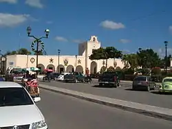 Ticul City Hall | |
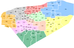 Region 7 Sur #089 | |
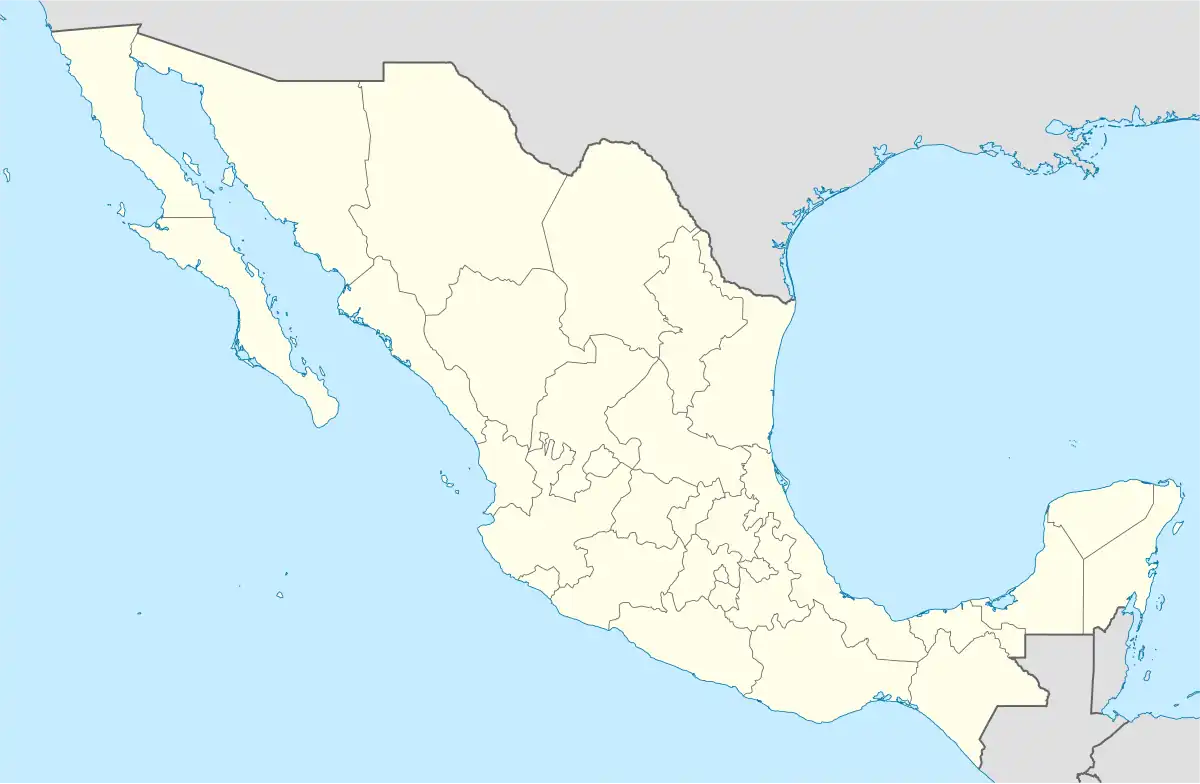 Ticul de Morales Location of the Municipality in Mexico | |
| Coordinates: 20°24′N 89°32′W | |
| Country | |
| State | |
| Government | |
| • Type | PAN 2018–2021[1] |
| • Municipal President | Camilo Moises Salomon Lopez [2] |
| Area | |
| • Total | 355.12 km2 (137.11 sq mi) |
| [2] | |
| Population (2010[3]) | |
| • Total | 37,685 |
| Time zone | UTC-6 (Central Standard Time) |
| • Summer (DST) | UTC-5 (Central Daylight Time) |
| Postal Code | 97860 |
| Area code | 997 |
| INEGI Code | 089 |
| Major Airport | Merida (Manuel Crescencio Rejón) International Airport |
| IATA Code | MID |
| ICAO Code | MMMD |
Climate
| Climate data for Ticul | |||||||||||||
|---|---|---|---|---|---|---|---|---|---|---|---|---|---|
| Month | Jan | Feb | Mar | Apr | May | Jun | Jul | Aug | Sep | Oct | Nov | Dec | Year |
| Average high °C (°F) | 29.8 (85.6) |
31.7 (89.1) |
34.1 (93.4) |
36.7 (98.1) |
37.7 (99.9) |
35.7 (96.3) |
35.3 (95.5) |
35.1 (95.2) |
34.3 (93.7) |
32.6 (90.7) |
31 (88) |
29.9 (85.8) |
33.7 (92.7) |
| Average low °C (°F) | 15 (59) |
15.9 (60.6) |
17.6 (63.7) |
19.4 (66.9) |
21.3 (70.3) |
21.9 (71.4) |
21.2 (70.2) |
21.6 (70.9) |
21.7 (71.1) |
20.6 (69.1) |
18.0 (64.4) |
16.3 (61.3) |
19.2 (66.6) |
| Average precipitation mm (inches) | 20 (0.8) |
130 (5) |
36 (1.4) |
51 (2) |
110 (4.5) |
170 (6.6) |
140 (5.7) |
170 (6.5) |
190 (7.5) |
120 (4.8) |
51 (2) |
41 (1.6) |
1,230 (48.4) |
| Source: Weatherbase[4] | |||||||||||||
Communities
The municipality is made up of 32 communities the most important are as follows:
Important people
Francisco Ché Cacique de Ticul who ruled from 1562-1569.
Picture gallery
Wikimedia Commons has media related to Ticul Municipality.
 The church at night
 City Hall
 Church
References
- "Presidente Municipal" (in Spanish). Mérida, Mexico: PRI. 2012. Retrieved 6 August 2015.
- "Municipios de Yucatán »Santa Elena" (in Spanish). Retrieved 13 November 2018.
- "Mexico In Figures:Sacalum, Yucatán". INEGI (in Spanish and English). Aguascalientes, México: Instituto Nacional de Estadística y Geografía (INEGI). Archived from the original on 6 May 2015. Retrieved 3 August 2015.
- "Weatherbase: Historical Weather for Ticul, Yucatán". Weatherbase. 2011. Retrieved on November 24, 2011.
Mérida (capital) | |||||||||||||||
| Topics |  | ||||||||||||||
| Metros | |||||||||||||||
| Larger cities | |||||||||||||||
| Smaller cities |
| ||||||||||||||
| Municipalities |
| ||||||||||||||
This article is issued from Wikipedia. The text is licensed under Creative Commons - Attribution - Sharealike. Additional terms may apply for the media files.