Ticapampa District
Ticapampa District is one of ten districts of the Recuay Province in Peru.[1]
Ticapampa | |
|---|---|
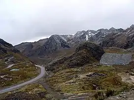 On the road above Qiruqucha | |
| Country | |
| Region | Ancash |
| Province | Recuay |
| Founded | October 12, 1921 |
| Capital | Ticapampa |
| Area | |
| • Total | 142.29 km2 (54.94 sq mi) |
| Elevation | 3,456 m (11,339 ft) |
| Population | |
| • Total | 2,566 |
| • Density | 18/km2 (47/sq mi) |
| Time zone | UTC-5 (PET) |
| UBIGEO | 021710 |
Geography
The Cordillera Blanca and the Cordillera Negra traverse the district. Some of the highest mountains of the district are listed below:[2]
- Khuchi Mach'ay
- Pamparahu Punta
- Puka Allpa
- Puka Mach'ay
- Pukarahu
- Qawish
- Rukutu Punta
- Tunshu
- Wank'ap'iti
- Waqra Qaqa
- Yanamaray
- Yanarahu
See also
References
- (in Spanish) Instituto Nacional de Estadística e Informática. Banco de Información Distrital Archived 2008-04-23 at the Wayback Machine. Retrieved April 11, 2008.
- escale.minedu.gob.pe - UGEL map of the Reucay Province (Ancash Region)
| Aija | |
|---|---|
| Antonio Raymondi | |
| Asunción | |
| Bolognesi | |
| Carhuaz | |
| Carlos Fermín Fitzcarrald | |
| Casma | |
| Corongo | |
| Huaraz | |
| Huari | |
| Huarmey | |
| Huaylas | |
| Mariscal Luzuriaga | |
| Ocros | |
| Pallasca | |
| Pomabamba | |
| Recuay | |
| Santa | |
| Sihuas | |
| Yungay | |
This article is issued from Wikipedia. The text is licensed under Creative Commons - Attribution - Sharealike. Additional terms may apply for the media files.