Thevalakkara
Thevalakkara is a village in the Karunagappally Taluk, Kollam District of the state of Kerala, India.[1] It is located near the coast of the Indian Ocean, about 13 kilometres north of the district capital Kollam, and 7 kilometres southeast of the subdistrict capital Karunagappally. It contains a Devi temple along with a church and a mosque. The kadappa at Thevalakara is where ship masts (kadappa) were made for centuries. In 2011, it has a total population of 42,977.[2]
Thevalakkara
Deva Loka Kara ( Area of GODS) | |
|---|---|
Village | |
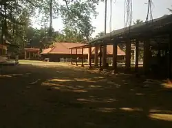 Thekkan Guruvayur Temple within the village | |
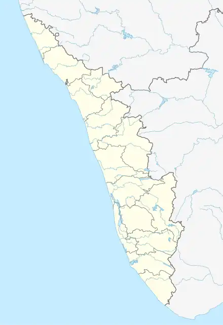 Thevalakkara Location in Kerala, India  Thevalakkara Thevalakkara (India) | |
| Coordinates: 09°01′00″N 76°35′00″E | |
| Country | |
| State | Kerala |
| District | Kollam |
| Taluk | Karunagappally |
| Government | |
| • Type | Gram Panchayat |
| Area | |
| • Total | 16.92 km2 (6.53 sq mi) |
| Elevation | 10 m (30 ft) |
| Population (2011) | |
| • Total | 42,977 |
| • Density | 2,500/km2 (6,600/sq mi) |
| Languages | |
| • Official | Malayalam, English |
| Time zone | UTC+5:30 (IST) |
| PIN | 690524 |
| STD code | 0476287 |
| Vehicle registration | KL-23 |
| Nearest city | Karunagappally |
| Lok Sabha constituency | Kollam |
| Vidhan Sabha constituency | Chavara |
Geography
Thevalakkara is located on the northwestern shore of the Ashtamudi Lake. The National Highway 183A passes through the village. Its average elevation is 10 metres above the sea level.[3]
Climate
Thevalakkara has a Tropical Monsoon Climate (Am). Its wettest month is June, with an average rainfall of 418 mm; and the driest month is January, with an average rainfall of 25 mm.
| Climate data for Thevalakkara | |||||||||||||
|---|---|---|---|---|---|---|---|---|---|---|---|---|---|
| Month | Jan | Feb | Mar | Apr | May | Jun | Jul | Aug | Sep | Oct | Nov | Dec | Year |
| Average high °C (°F) | 30.9 (87.6) |
32 (90) |
32.2 (90.0) |
31.2 (88.2) |
29.9 (85.8) |
28.2 (82.8) |
27.8 (82.0) |
27.8 (82.0) |
28.3 (82.9) |
28.6 (83.5) |
28.9 (84.0) |
29.7 (85.5) |
29.6 (85.4) |
| Daily mean °C (°F) | 26.5 (79.7) |
27.3 (81.1) |
28 (82) |
27.9 (82.2) |
27.3 (81.1) |
26 (79) |
25.5 (77.9) |
25.5 (77.9) |
25.8 (78.4) |
25.9 (78.6) |
26 (79) |
26.2 (79.2) |
26.5 (79.7) |
| Average low °C (°F) | 22.9 (73.2) |
23.5 (74.3) |
24.7 (76.5) |
25.4 (77.7) |
25.4 (77.7) |
24.6 (76.3) |
24.1 (75.4) |
24 (75) |
24.1 (75.4) |
24 (75) |
23.7 (74.7) |
23.3 (73.9) |
24.1 (75.4) |
| Average rainfall mm (inches) | 25 (1.0) |
30 (1.2) |
75 (3.0) |
167 (6.6) |
314 (12.4) |
418 (16.5) |
363 (14.3) |
294 (11.6) |
247 (9.7) |
267 (10.5) |
189 (7.4) |
65 (2.6) |
2,454 (96.8) |
| Source: Climate-Data.org[4] | |||||||||||||
Demographics
According to the 2011 Indian Census, Thevalakara has a total of 10,473 households. Out of the 42,977 residents, 20,278 are male and 22,699 are female. The total literacy rate is 82.52%, with 16,960 of the male population and 18,506 of the female population being literate. The census location code of the village is 628361.[2]
Notable personalities
References
- "Census of India : Villages with population 5000 & above". Registrar General & Census Commissioner, India. Retrieved 10 December 2008.
- "Basic Population Figures of India, States, Districts, Sub-District and Village, 2011". censusindia.gov.in. Archived from the original on 2 March 2023. Retrieved 17 April 2023.
- "Thevalakkara topographic map, elevation, terrain". Topographic maps. Retrieved 19 April 2023.
- "Thevalakkara climate: Temperature Thevalakkara & Weather By Month - Climate-Data.org". en.climate-data.org. Retrieved 19 April 2023.
| City Corporations |  | |
|---|---|---|
| Municipalities | ||
| Revenue Divisional Office | ||
| Talukas and villages | ||