Teakettle Mountain
Teakettle Mountain, elevation 13,825 ft (4,214 m), is a summit in the Sneffels Range of southwest Colorado. The peak is west of Ouray in the Uncompahgre National Forest.
| Teakettle Mountain | |
|---|---|
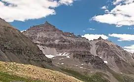 South aspect | |
| Highest point | |
| Elevation | 13,825 ft (4,214 m)[1][2] |
| Prominence | 739 ft (225 m)[2] |
| Isolation | 1.68 mi (2.70 km)[2] |
| Coordinates | 38°00′03″N 107°45′42″W[3] |
| Geography | |
 Teakettle Mountain | |
| Location | Ouray County, Colorado, U.S.[3] |
| Parent range | San Juan Mountains, Sneffels Range[2] |
| Topo map | USGS 7.5' topographic map Mount Sneffels, Colorado[3] |
See also
References
- The elevation of Teakettle Mountain includes an adjustment of +1.850 m (+6.07 ft) from NGVD 29 to NAVD 88.
- "Teakettle Mountain, Colorado". Peakbagger.com. Retrieved November 6, 2014.
- "Teakettle Mountain". Geographic Names Information System. United States Geological Survey, United States Department of the Interior. Retrieved November 6, 2014.
External links
 Media related to Teakettle Mountain at Wikimedia Commons
Denver (capital) | |
| Topics |
|
| Society | |
| Cities |
|
| Counties |
|
| Regions |
|
| Federal |
| ||||||||||||||||||||||||||||||||
|---|---|---|---|---|---|---|---|---|---|---|---|---|---|---|---|---|---|---|---|---|---|---|---|---|---|---|---|---|---|---|---|---|---|
| State |
| ||||||||||||||||||||||||||||||||
| Trails |
| ||||||||||||||||||||||||||||||||
This article is issued from Wikipedia. The text is licensed under Creative Commons - Attribution - Sharealike. Additional terms may apply for the media files.