Taunggyi Township
Taunggyi Township is a township of Taunggyi District in the Shan State of Myanmar. The principal town is Taunggyi.
Taunggyi Township | |
|---|---|
 Shwe Bhone Pwint Pagoda and Taunggyi | |
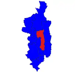 Location in Taunggyi district | |
 Taunggyi Township | |
| Coordinates: 20°47′N 97°02′E | |
| Country | |
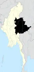
| State | Shan State |
| District | Taunggyi District |
| Capital | Taunggyi |
| Area | |
| • Total | 420.9 sq mi (1,090.0 km2) |
| Population (2014) | 381,639 |
| Time zone | UTC+6:30 (MST) |
Borders
Taunggyi Township is bordered[1] by the following townships:
- Lawksawk to the north
- Hopong to the north and east
- Hsi Hseng to the east and south
- Nyaungshwe (Yawunghwe) to the west
- Kalaw to the west
Formerly, the northern half of Hopong Township was part of Mong Kung Township (Mongkaung Township).
Demographics
2014
| Year | Pop. | ±% |
|---|---|---|
| 1973 | — | |
| 1983 | — | |
| 2014 | 381,639 | — |
| Source: Ministry of Labor, Immigration, and Population data | ||
The 2014 Myanmar Census reported that Taunggyi Township had a population of 381,639.[2] The population density was 350.1 people per km².[2] The census reported that the median age was 26.2 years, and 95 males per 100 females.[2] There were 82,604 households; the mean household size was 4.3.[2]
Communities
In addition to the town of Taunggyi itself, there are two large towns in Taunggyi Township: Ayetharyar and Kyauktalonegyi. Among the many villages and wards (village census tracts) in Taunggyi Township are:
Notes
- "Myanmar States/Divisions & Townships Overview Map" Myanmar Information Management Unit (MIMU)
- "Taunggyi Township Report" (PDF). 2014 Myanmar Population and Housing Census. October 2017.
- "Hang Si Map — Satellite Images of Hang Si" Maplandia
- "Htedaung Map — Satellite Images of Htedaung" Maplandia
- "Kanpaw Tang-tok Map — Satellite Images of Kanpaw Tang-tok" Maplandia
- "Kon-kawng Map — Satellite Images of Kon-kawng" Maplandia
- "Lothkan Map — Satellite Images of Lothkan" Maplandia
- "Mai Tang Hsong Map — Satellite Images of Mai Tang Hsong" Maplandia
- "Man Kong Map — Satellite Images of Man Kong" Maplandia
- "Nyawngkon Map — Satellite Images of Nyawngkon" Maplandia
- "Sakangyi Map — Satellite Images of Sakangyi" Maplandia
- "Shwenyaung Map — Satellite Images of Shwenyaung" Maplandia
- "Wan Mansaw Map — Satellite Images of Wan Mansaw" Maplandia
External links
- "Taunggyi Google Satellite Map" Maplandia World Gazetteer
- "Taunggyi Township Shan State" Map, 14 June 2010, Myanmar Information Management Unit (MIMU)