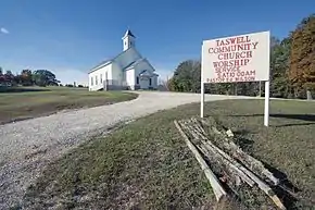
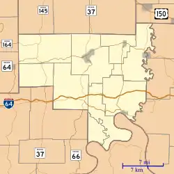
Taswell, Indiana
Taswell is an unincorporated community in Patoka Township, Crawford County, Indiana, located on State Road 64 west of the county seat of English.
Taswell | |
|---|---|
 | |
 Taswell | |
| Coordinates: 38°20′03″N 86°33′40″W | |
| Country | United States |
| State | Indiana |
| County | Crawford |
| Township | Patoka |
| Elevation | 778 ft (237 m) |
| ZIP code | 47175 |
| GNIS feature ID | 451541 |
History
A post office was established at Taswell in 1882, and remained in operation until it was discontinued in 1996.[2] It was intended that the community be named for the Laswell family of settlers, but when the postal authorities misspelled the name Taswell, the new name stuck.[3]
Geography
Taswell is located at 38°20′05″N 86°33′40″W.
References
- "US Board on Geographic Names". United States Geological Survey. October 25, 2007. Retrieved January 31, 2008.
- "Crawford County". Jim Forte Postal History. Retrieved August 30, 2014.
- Baker, Ronald L. (October 1995). From Needmore to Prosperity: Hoosier Place Names in Folklore and History. Indiana University Press. p. 320. ISBN 978-0-253-32866-3.
...for the local Laswell family, but through a clerical error...
External links
 Media related to Taswell, Indiana at Wikimedia Commons
Municipalities and communities of Crawford County, Indiana, United States | ||
|---|---|---|
| Towns | Map of Indiana highlighting Crawford County | |
| Townships | ||
| CDPs | ||
| Other communities | ||
| Footnotes | ‡This populated place also has portions in an adjacent county or counties | |
This article is issued from Wikipedia. The text is licensed under Creative Commons - Attribution - Sharealike. Additional terms may apply for the media files.