Taston
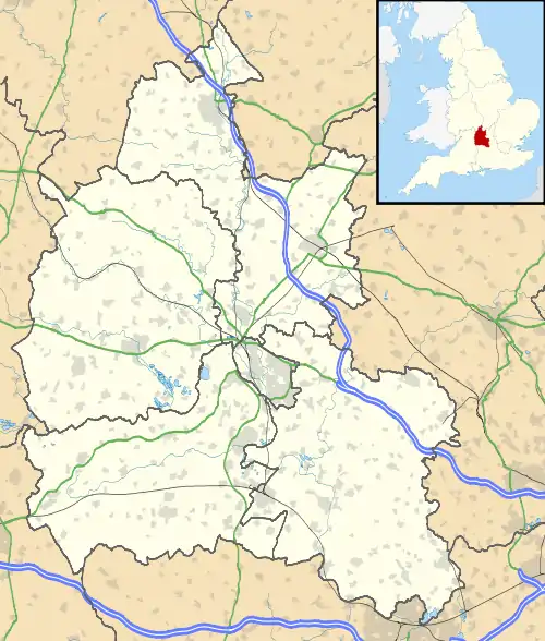
Taston is a hamlet in Spelsbury civil parish, about 1.6 miles (2.6 km) north of Charlbury and 4 miles (6.4 km) southeast of Chipping Norton, Oxfordshire.
| Taston | |
|---|---|
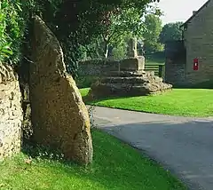 Thor Stone (left foreground), with the Medieval preaching cross beyond | |
 Taston Location within Oxfordshire | |
| OS grid reference | SP3621 |
| Civil parish | |
| District | |
| Shire county | |
| Region | |
| Country | England |
| Sovereign state | United Kingdom |
| Post town | Chipping Norton |
| Postcode district | OX7 |
| Dialling code | 01608 |
| Police | Thames Valley |
| Fire | Oxfordshire |
| Ambulance | South Central |
| UK Parliament | |
| Website | Spelsbury Parish Council |
Name
Name history
Survey of English Place-Names: [1]
The original Old Danish name[lower-alpha 1] might have been:
- Þórr steinn.[lower-alpha 2] [lower-alpha 3]
Toponym ( Thorstan )
The name element Thor is a reference to the Norse God Thor.[lower-alpha 4] [lower-alpha 5] The name element stan is from Old English stān ( " stone " ).[lower-alpha 6]
The toponym might be:
- Thor stone.
- Thor's stone.
Thor Stone
The Thor Stone is a monolithic standing stone that stands about seven-foot tall in the centre of Taston. [lower-alpha 7] [lower-alpha 8] It is a menhir, meaning that it was man handled there by humans. A local myth maintains that the stone portrays the image of a thunderbolt, and that it was created by a thunderbolt from Thor himself. [lower-alpha 9] [4] The Thor Stone is a scheduled monument.[5]
The Norse God Thor was one of the most powerful of the many Norse Gods who featured in Norse mythology. [lower-alpha 10] [lower-alpha 11] According to Norse mythology, Thor was the son of the Norse god Óðinn and the Norse goddess Jörð.[lower-alpha 12] [lower-alpha 13]
It would be expected that the Danish people who settled in Oxfordshire during the Viking age [lower-alpha 14] continued to follow the traditions and beliefs that were customary in their Scandinavian homeland. Stories from Norse mythology were retold and passed down from generation to generation. [lower-alpha 15] [lower-alpha 16]
Natural England maps
Maps showing Access, Designations and other criteria from Natural England: [lower-alpha 17]
- MAGiC MaP : Taston – Scheduled Monuments.[8]
- MAGiC MaP : Taston – Listed Buildings.[9]
- MAGiC MaP : Taston – Grims Ditch.[10]
- MAGiC MaP : Taston – Monuments – Spelsbury Parish boundary.[11]
Listed buildings

List Entry table
| List Entry | Category | Short description |
|---|---|---|
| 1251432[12] | Grade II* | CROSS. Medieval.[lower-alpha 18] |
| 1262715[13] | Grade II | MIDDLE FARMHOUSE. C17 and early C18 |
| 1251433[14] | Grade II | BARN. Early C18 and 1884 |
| 1262714[15] | Grade II | THE FIRKINS, Small house. early C18 |
| 1262769[16] | Grade II | MEMORIAL FOUNTAIN. 1862 |
Medieval village cross
At the centre of Taston are the base and broken shaft of a Medieval preaching cross.[17] It is a Grade II* listed building.[12]
Middle farmhouse and barn
Middle Farmhouse is a house built of coursed rubble in the 17th and early 18th centuries.[13] Part of the roof is of Stonesfield slate. The farmstead has a four-bay barn that was built of stone early in the 18th century and altered in 1884.[14]
The Firkins
The Firkins is a small house near Thorsbrook Spring. It is built of rubble and probably dates from early in the 18th century.[15]
Memorial fountain
At Thorsbrook Spring, about 140 yards (130 m) southeast of the preaching cross, is a Victorian Gothic Revival memorial fountain. It was built in 1862 in memory of Henrietta, Viscountess Dillon,[16] wife of Henry Dillon, 13th Viscount Dillon.
History
Danish Vikings
The Danish Viking warlord Guthrum based his army at Cirencester for about a year following his defeat at the Battle of Edington. [lower-alpha 19] [lower-alpha 20] In 879 Guthrum moved his large army from Cirencester to East Anglia, as had been agreed in the Treaty of Alfred and Guthrum.
Taston is about 3 miles (4.8 km) north of the Akeman Street Roman road, which connected Cirencester directly with Alchester (Roman town) near Bicester. Alchester was a strategic location with connecting routes north and south:
- The route north connected with Watling Street at Lactodurum (Towcester).[lower-alpha 21]
- The route south connected with the River Thames at Dorchester on Thames.[lower-alpha 22]
It would be expected that Guthrum's army used Akeman Street to travel from Cirencester to East Anglia. [lower-alpha 24] It is possible that not all of Guthrum's army recruits continued all of the way to East Anglia. There is a cluster of Danish and Old Norse place names to the north of Akeman Street.[lower-alpha 25] Oxfordshire became increasingly populated by Danes of Viking age origin as waves of migrants crossed the North sea and followed the River Thames inland to Oxford.[lower-alpha 26]
Local place names
Place name table
There is a cluster of Old Danish and Old Norse place names near Taston:
| Distance[lower-alpha 27] | Direction | Place name | Danish Old Norse |
|---|---|---|---|
| Taston near Enstone, Oxfordshire. | Norse god Thor | ||
| 1.5 miles (2.4 km) | south east | Grim's Ditch. | Norse god Odin.[lower-alpha 28] |
| 1.5 miles (2.4 km) | north east | Hoar Stone (tumulus) near Enstone. | Old Norse haugr ( " tumulus " ) |
| 1.5 miles (2.4 km) | north west | Hawk Stone. | Old Norse haugr |
| 6 miles (9.7 km) | north east | Hoar Stone near Barton Abbey. | Old Norse haugr |
| 8 miles (13 km) | north east | Dane Hill near Duns Tew.[19] | Dane Hill |
| 12 miles (19 km) | south east | Seacourt near the City of Oxford. | Old Norse sef ( " sedge, rush " ) |
Grim's Ditch
Taston is very close to a series of defensive earthwork's known as Grim's Ditch around Ditchley Park. The earthwork's extend south as far as Akeman Street Roman road and were probably built or re-used by the Roman army to resist attack from the Dobunni.[lower-alpha 29] The North Oxfordshire Grim's Ditch is one of many earthwork's of a similar name in the south and east of England. The reason why they are all called " Grim's Ditch " is not known, since they are believed to have different origins. The name " Grim " was a common Old Danish personal-name during the Viking Age.[20] The name was associated with the Norse god Óðinn, known as Wōden to the Anglo Saxons.[lower-alpha 30] [lower-alpha 31]
Dane Hill
Dane Hill is a small hamlet on the A4260 road from Oxford to Banbury.[19] The hamlet might mark the most westerly extent of Danish controlled territory into Oxfordshire, following the Treaty of Alfred and Guthrum.
A 19th century map shows how territory was divided between the Anglo Saxons (Pink) and the Danes (Blue):[lower-alpha 32]
- Wantage – Kingdom of Wessex – Alfred the Great (Pink).
- Warwick – English Mercia – Ceolwulf II of Mercia (Pink).
- Oxford – Wessex and Mercia (Pink).[lower-alpha 33]
- Buckingham – Kingdom of Guthrum (Blue).[lower-alpha 34]
- Northampton – Danish Mercia (Blue).[lower-alpha 35] [lower-alpha 36]
The Anglo Saxons later gained territory from the Danes, and Buckingham became a Mercian burh, one of a network of fortified burhs created to defend Mercia and Wessex against the Danes.[lower-alpha 37]
References

Notes
- See (Contents) > History > Danish Vikings.
- The Old Norse spelling of " Thor " used a Thorn ( Þ ) which was later replaced with a Th (digraph).
- WiKtionary : Old Norse < steinn >
- " a stone, boulder, rock. "
- See Thor >. . .In Norse mythology, he is a hammer-wielding god associated with lightning, thunder. . .
- The Norse god Thor was also known as " Thunder "
- WiKtionary : Old English < stân >
- " stone ".
- Thor Stone – Grid ref SP 35940 22082.
- The Old Stones. . .a hefty seven foot stone that leans dramatically into a garden wall in the centre of the village. One story goes that it was a thunderbolt thrown by Thor himself. . .[2]
- Thor Stone Standing Stone (Menhir) in Oxfordshire at SP 3593 2208. . .An impressive seven-foot tall standing stone,. . .told in local folklore to have been a thunderbolt cast down from the skies by Thor. . .first recorded in the late thirteenth century in the survey of the Chadlington hundred.[3]
- Vikings; A History. . .dedicated to the most powerful of the Old Norse Gods. Thor, God of thunder (and by some measure the most powerful of them all) had pride of place. . .[6]
- Vikings; A History. . .Known today as the Repton Warrior, he was buried with full Viking honours. . .and around his neck a little silver Thor's hammer. . .the thunder-bringing hammer called Mjölnir. . .[7]
- See (Contents) > Local place names > Grim's Ditch > . . .associated with the Norse god Óðinn.
- WiKtionary : Old Norse < Grímr >
- " a male given name, especially one of Óðinn's name ".
- See (Contents) > History > Danish Vikings.
- See also Thor's magic hammer
- See also Thor's fight with the World Serpent
- MAGiC MaP: See Table of Contents:
- Administrative Geographies > Parish boundary.
- Designations > Scheduled Monuments.
- Designations > Listed Buildings.
- The cross is both a scheduled monument and a listed building
- See Battle of Edington > Consequences.
- The Watlington Viking Hoard.[18] .following Alfred's defeat of Guthrum's army at Edington in 878, Guthrum's army moved north to Cirencester in Southern Mercia where they based themselves for about a year. . .[18]
- Some historians consider that Watling Street defined the western extent of the Danelaw.
- The River Thames was an important navigation route for Danish migrant's who had crossed the North sea.
- Akeman Street from St Albans to Cirencester.
- The Watlington Viking Hoard.[18] .Guthrum's army moved in 879 from Cirencester to East Anglia. . .A large army could only have progressed along a limited number of routes. . .These were restricted to re-used Roman roads. . .One was a Roman road[lower-alpha 23]. . .from Cirencester running to the north of Oxford and continuing to St Albans. . .[18]
- See (Contents) > Local place names.
- See Eadwig's Charter to Abingdon Abbey c.957 > Danes in Oxford.
- Distance from Taston.
- WiKtionary : Old Norse < Grímr >
- " a male given name, especially one of Óðinn's name ".
- See Ditchley Park > Archaeology > . . .Grim's Ditch
- WiKtionary : Old Norse < Grímr >
- " a male given name, especially one of Óðinn's name ".
- See Grim's Ditch > Etymology
- See Treaty of Alfred and Guthrum > Terms > . . .19th century map
- The Early Middle Ages. . .It may be that Oxford was chosen for the meetings because of its neutral position, having ties with both Wessex and Mercia but being identified with neither. . .[21]
- The map shows that the boundary south of Buckingham extended in a westerly direction as far as the River Cherwell, before heading north towards Banbury and Daventry.
- The Danish territory shown on the map was divided north – south by a boundary line from Buckingham to The Wash.
- North – Danish Mercia.
- South – Kingdom of Guthrum.
- The Danish controlled territory later became known as the Danelaw.
- The Origins of Oxford. . . " The details of the West Saxon defence system are recorded in the Burghal Hidage " . . . " between 914 and 918 and includes the Mercian burh of Buckingham as well as Oxford " . . . " an earlier version of the 'hidage' which omitted Buckingham but included Oxford. " . . .[21]
Citations
-
- "Survey of English Place-Names: Taston". University of Nottingham. Retrieved 2 May 2023.
- Burnham 2018, pp. 116.
-
- "Thor Stone - Standing Stone (Menhir) in England in Oxfordshire". The Megalithic Portal. Retrieved 2 May 2023.
- faerygirl (6 January 2011). "Thor Stone; Standing Stone / Menhir". The Modern Antiquarian. Julian Cope. Retrieved 2 May 2023.
- Historic England. "Taston standing stone 12m north of Taston village cross (1008407)". National Heritage List for England. Retrieved 2 May 2023.
- Oliver 2012, pp. 119.
- Oliver 2012, pp. 230–231.
- "MAGiC MaP : Taston – Scheduled Monuments". Natural England – Magic in the Cloud.
- "MAGiC MaP : Taston – Listed Buildings". Natural England – Magic in the Cloud.
- "MAGiC MaP : Taston – Grims Ditch". Natural England – Magic in the Cloud.
- "MAGiC MaP : Taston – Spelsbury Parish boundary". Natural England – Magic in the Cloud.
- Historic England. "Cross (1251432)". National Heritage List for England. Retrieved 27 February 2012.
- Historic England. "Middle Farmhouse (1262715)". National Heritage List for England. Retrieved 27 February 2012.
- Historic England. "Barn Approximately 15 Metres South East of Middle Farmhouse (1251433)". National Heritage List for England. Retrieved 27 February 2012.
- Historic England. "The Firkins (1262714)". National Heritage List for England. Retrieved 27 February 2012.
- Historic England. "Memorial Fountain (1262769)". National Heritage List for England. Retrieved 27 February 2012.
- Sherwood, Jennifer; Pevsner, Nikolaus (1974). Oxfordshire. The Buildings of England. Harmondsworth: Penguin Books. p. 776. ISBN 0-14-071045-0.
- Williams & Naylor 2016, pp. 29.
- "MAGiC MaP : Dane Hill near Duns Tew". Natural England – Magic in the Cloud.
-
- "Nordic Names – Grim". Nordic Names. Retrieved 2 May 2023.
- Crossley & Elrington 1979, pp. 3–73.
Sources
- Burnham, Andy (2018). The Old Stones. Watkins Media Limited. ISBN 9781786781543.
- Williams, Gareth; Naylor, John (2016). King Alfreds Coins, The Watlington Viking Hoard. Ashmolean museum, University of Oxford. ISBN 978-1-910807-13-2.
- Oliver, Neil (2012). Vikings; A History. Phoenix. ISBN 978-1-7802-2282-0.
- Crossley, Alan; Elrington, C R, eds. (1979). 'Medieval Oxford', A History of the County of Oxford: Volume 4. British History Online. pp. 3–73. Retrieved 2 June 2023.
