Tanjombato
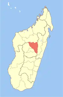
Tanjombato is a suburb and a rural municipality of Antananarivo in the Analamanga Region ( Central Highlands of Madagascar). It belongs to the district of Antananarivo-Atsimondrano and had a population of 50,373 as of 2018.[2]
Tanjambato | |
|---|---|
 The Ikopa River at Tanjombato | |
 Tanjambato Location in Madagascar | |
| Coordinates: 18°57′00″S 47°31′00″E | |
| Country | |
| Region | Analamanga |
| District | Antananarivo-Atsimondrano |
| Area | |
| • Land | 7 km2 (3 sq mi) |
| Elevation | 1,251 m (4,104 ft) |
| Population (2018) | |
| • Total | 50,373 |
| Time zone | UTC3 (EAT) |
| postal code | 102 |
It is situated at 7 km South from downtown Antananarivo and is crossed by the Ikopa River and the National Road 7.[3]
References
- LIENS SOCIAUX DANS LES COMMUNES RURALES DE TANJOMBATO ET D’ANDOHARANOFOTSY
- RECENSEMENT GÉNÉRAL DE LA POPULATION ET DE L’HABITATION DE 2018 DE MADAGASCAR
- LIENS SOCIAUX DANS LES COMMUNES RURALES DE TANJOMBATO ET D’ANDOHARANOFOTSY
Wikimedia Commons has media related to Tanjombato.
This article is issued from Wikipedia. The text is licensed under Creative Commons - Attribution - Sharealike. Additional terms may apply for the media files.
