Tangahoe Formation
The Tangahoe Formation is a geologic formation in the southwestern North Island of New Zealand.

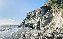
The formation occurs in the Taranaki and Manawatu-Wanganui Regions, spreading in an east–west band for 200 kilometres (120 mi) from the volcanic deposits of Mount Taranaki in the west to the Ruahine Ranges in the east, in a band with an average width of around 20 kilometres (12 mi).[1] It becomes exposed at its western end close to the Tasman Sea coast near Hawera in a series of cliff faces.[2] The formation takes its name from the Tangahoe River, close to the exposed cliffs.
The formation is sedimentary, composed largely of muddy sandstones, and was formed beneath sea level in the Waipipian stage of the mid-Pliocene some 3.4 to 3.0 million years ago.[2]
The formation is an important fossil site. Many marine fossils have been recovered from its mudstones, including the megalodon shark, giant petrel Macronectes tinae, penguin Eudyptes atatu, monk seal Eomonachus belegaerensis, and cetaceans.[3][4]
References
- Kamp, P. J. J., et al. (2023) "Geology map of western North Island, showing the main stratigraphic units in the Taranaki, King Country and Wanganui basins," www.researchgate.net. Accessed 9 February 2023.
- Naish, T. R., et al. (2005) "An integrated sequence stratigraphic, palaeoenvironmental, and chronostratigraphic analysis of the Tangahoe Formation, southern Taranaki coast, with implications for mid-Pliocene (c. 3.4–3.0 Ma) glacio-eustatic sea-level changes," Journal of the Royal Society of New Zealand, 35(1&2), 151-196. Accessed 9 February 2023.
- Lambert, R., "Taranaki region - Geology and climate," Te Ara - the Encyclopedia of New Zealand Accessed 9 February 2023.
- Tennyson, A.J.D.; Salvador, R.B. (2023). "A New Giant Petrel (Macronectes, Aves: Procellariidae) from the Pliocene of Taranaki, New Zealand". Taxonomy. 3 (1): 57–67. doi:10.3390/taxonomy3010006.