Taihe County, Jiangxi
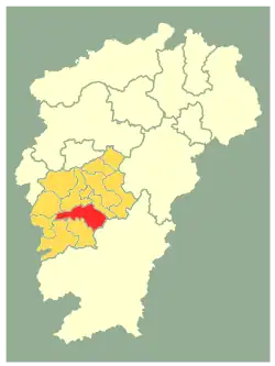
Taihe County (simplified Chinese: 泰和县; traditional Chinese: 泰和縣; pinyin: Tàihé Xiàn) is a county of southwest Jiangxi province, People's Republic of China, situated on the west (left) bank of the Gan River. It is under the jurisdiction of the prefecture-level city of Ji'an, 37 kilometres (23 mi) to the north-northeast.
Taihe County
泰和县 Taiho | |
|---|---|
 Location in Ji'an City (yellow) and Jiangxi province | |
| Coordinates: 26°47′24″N 114°54′32″E | |
| Country | People's Republic of China |
| Province | Jiangxi |
| Prefecture-level city | Ji'an |
| Area | |
| • Total | 2,666 km2 (1,029 sq mi) |
| Elevation | 57 m (188 ft) |
| Population (2010) | |
| • Total | 512,225 |
| • Density | 190/km2 (500/sq mi) |
| Time zone | UTC+8 (China Standard) |
| Area code | 0796 |
| GDP (RMB) | 4.692 billion |
| Website | http://www.jxth.gov.cn/ |
Its area is almost the size of that of Rhode Island.[1]
Administrative divisions
์Nowadays, Taihe County consists of 16 towns and 6 townships.[2]
- 16 towns
|
|
- 6 townships
|
|
Demographics

History
According to recent archaeological discoveries, the history of Taihe County may date back to the western Zhou dynasty. Readers of English who are interested in this county should read John W. Dardess, A Ming Society: T'ai-ho County, Kiangsi, in the Fourteenth to Seventeenth Centuries (Berkeley: University of California Press, 1996). The book was preceded by a number of articles about the county, including John W Dardess, "A Ming Landscape: Settlement, Land Use, Labor, and Estheticism in T'ai-ho County, Jiangxi," Harvard Journal of Asiatic Studies 49.1 (1989): 295-364.
Climate
| Climate data for Taihe (1991–2020 normals, extremes 1981–2010) | |||||||||||||
|---|---|---|---|---|---|---|---|---|---|---|---|---|---|
| Month | Jan | Feb | Mar | Apr | May | Jun | Jul | Aug | Sep | Oct | Nov | Dec | Year |
| Record high °C (°F) | 26.5 (79.7) |
31.0 (87.8) |
33.2 (91.8) |
36.2 (97.2) |
36.8 (98.2) |
38.3 (100.9) |
41.4 (106.5) |
41.5 (106.7) |
38.5 (101.3) |
36.9 (98.4) |
33.3 (91.9) |
27.4 (81.3) |
41.5 (106.7) |
| Average high °C (°F) | 10.9 (51.6) |
14.1 (57.4) |
17.7 (63.9) |
24.3 (75.7) |
28.6 (83.5) |
31.4 (88.5) |
34.8 (94.6) |
34.2 (93.6) |
30.6 (87.1) |
25.7 (78.3) |
19.7 (67.5) |
13.6 (56.5) |
23.8 (74.9) |
| Daily mean °C (°F) | 7.2 (45.0) |
9.8 (49.6) |
13.4 (56.1) |
19.5 (67.1) |
24.0 (75.2) |
27.0 (80.6) |
29.8 (85.6) |
29.1 (84.4) |
25.8 (78.4) |
20.8 (69.4) |
14.9 (58.8) |
9.2 (48.6) |
19.2 (66.6) |
| Average low °C (°F) | 4.6 (40.3) |
6.9 (44.4) |
10.4 (50.7) |
16.2 (61.2) |
20.7 (69.3) |
24.0 (75.2) |
26.2 (79.2) |
25.6 (78.1) |
22.4 (72.3) |
17.2 (63.0) |
11.5 (52.7) |
6.0 (42.8) |
16.0 (60.8) |
| Record low °C (°F) | −4.1 (24.6) |
−2.8 (27.0) |
−1.2 (29.8) |
4.0 (39.2) |
11.1 (52.0) |
14.9 (58.8) |
19.0 (66.2) |
20.2 (68.4) |
15.0 (59.0) |
4.0 (39.2) |
0.3 (32.5) |
−6.0 (21.2) |
−6.0 (21.2) |
| Average precipitation mm (inches) | 70.4 (2.77) |
84.1 (3.31) |
159.1 (6.26) |
173.9 (6.85) |
211.4 (8.32) |
254.4 (10.02) |
122.0 (4.80) |
133.0 (5.24) |
69.9 (2.75) |
58.8 (2.31) |
74.1 (2.92) |
52.5 (2.07) |
1,463.6 (57.62) |
| Average precipitation days (≥ 0.1 mm) | 13.3 | 12.9 | 18.3 | 17.7 | 17.5 | 15.9 | 10.9 | 12.5 | 9.2 | 6.9 | 9.5 | 10.0 | 154.6 |
| Average snowy days | 2.4 | 1.3 | 0.3 | 0 | 0 | 0 | 0 | 0 | 0 | 0 | 0 | 0.6 | 4.6 |
| Average relative humidity (%) | 79 | 79 | 81 | 79 | 79 | 80 | 72 | 75 | 76 | 74 | 77 | 76 | 77 |
| Mean monthly sunshine hours | 66.8 | 70.0 | 75.6 | 104.2 | 123.6 | 133.5 | 230.8 | 203.9 | 154.7 | 146.0 | 114.9 | 103.4 | 1,527.4 |
| Percent possible sunshine | 20 | 22 | 20 | 27 | 30 | 32 | 55 | 51 | 42 | 41 | 36 | 32 | 34 |
| Source: China Meteorological Administration[5][6] | |||||||||||||
Culture
Its famous landmark is K'uai-ko Pavilion, which Huang Tingjian wrote about.[1]
Famous Local Products
One of the most famous local products of Taihe County is Gallus domesticus, called "Taihe Wuji" in Chinese.
Notes and references
- Chu, Hung-Lam (1998). "A Ming Society: T'ai-ho County, Kiangsi, in the Fourteenth to Seventeenth Century". 5 (2). China Review International: 401–405.
{{cite journal}}: Cite journal requires|journal=(help) - Cited: p. 401: "In the minds of Chinese literati, T'ai-ho County, covering an area slightly smaller than Rhode Island, in the southwestern part of Kiangsi Province,[...]" - "南京市-行政区划网 www.xzqh.org" (in Chinese). XZQH. Retrieved 2012-05-24.
- (in English) National Population Statistics Materials by County and City - 1999 Period, in China County & City Population 1999, Harvard China Historical GIS
- (in English) Government of Taihe County, Jiangxi Province, China - 2008 Period, in Taihe China Archived 2011-11-11 at the Wayback Machine
- 中国气象数据网 – WeatherBk Data (in Simplified Chinese). China Meteorological Administration. Retrieved 28 June 2023.
- 中国气象数据网 (in Simplified Chinese). China Meteorological Administration. Retrieved 28 June 2023.
Further reading
- John W. Dardess (1996). A Ming Society: Tʻai-ho County, Kiangsi, Fourteenth to Seventeenth Centuries. University of California Press. ISBN 978-0-520-20425-6.
- Qian Hang (钱杭; Qián Háng; Ch'ien Hang), 传统与转型: 江西泰和农村宗族形态; Chuántǒng yǔ Zhuǎnxíng: Jiāngxī Tàihé Nóngcūn Zōngzú Xíngtài; Ch'uan-t'ung yu chuan-hsing: Chiang-hsi Tai-ho nung-ts'un tsung-tsu hsing-t'ai. 上海社会科学院出版社, 1995 (Shanghai). See profile at Google Books.
External links
- (in Chinese and English) Government site - Google translation