Stonelands
Stonelands is a rural locality in the South Burnett Region, Queensland, Australia.[2] In the 2016 census, Stonelands had a population of 51 people.[1]
| Stonelands Queensland | |||||||||||||||
|---|---|---|---|---|---|---|---|---|---|---|---|---|---|---|---|
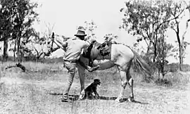
 Stockman at Stonelands, circa 1920 | |||||||||||||||
 Stonelands | |||||||||||||||
| Coordinates | 26.0483°S 151.7038°E | ||||||||||||||
| Population | 51 (2016 census)[1] | ||||||||||||||
| • Density | 0.3043/km2 (0.788/sq mi) | ||||||||||||||
| Postcode(s) | 4612 | ||||||||||||||
| Area | 167.6 km2 (64.7 sq mi) | ||||||||||||||
| Time zone | AEST (UTC+10:00) | ||||||||||||||
| Location | |||||||||||||||
| LGA(s) | South Burnett Region | ||||||||||||||
| State electorate(s) | Nanango | ||||||||||||||
| Federal division(s) | Flynn | ||||||||||||||
| |||||||||||||||
Geography
The locality is bounded to the north-east and east by Barambah Creek, which is a tributary of the Burnett River, and to the south-west by Gayndah Hivesville Road.[3]
Beninfi State Forest is in the north-west of the locality and Woroon State Forest 2 is in the west of the locality extending into neighbouring Wigton.[3]
Apart from the state forests, the predominant land use is grazing on native vegetation with some crop-growing and plantation forestry.[3]
History
Stonelands State School opened on 25 January 1932 and closed on 31 March 1967.[4] It was at 983 Stonelands Road (26.0826°S 151.7140°E). It was immediately west of the homestead of Stonelands pastoral station (26.0831°S 151.7199°E).[5][6]
In the 2016 census, Stonelands had a population of 51 people.[1]
Education
There are no schools in Stonelands. The nearest government primary schools are Windera State School in neighbouring Windera to the north-east, Cloyna State School in Cloyna to the east, and Proston State School in Proston to the south-west. The nearest government secondary schools are Proston State School (to Year 10), Murgon State High School (to Year 12) in Murgon to the south-east and Burnett State College (to Year 12) in Gayndah to the north.[3]
Facilities
Despite the name, Abbeywood Rural Fire Station is at 6461 Gayndah Hivesville Road in Stonelands (26.1200°S 151.6614°E); the Gayndah Hivesville Road is the border between the localities of Stonelands and Abbeywood.[7]
References
- Australian Bureau of Statistics (27 June 2017). "Stonelands (SSC)". 2016 Census QuickStats. Retrieved 20 October 2018.
- "Stonelands – locality in South Burnett Region (entry 46266)". Queensland Place Names. Queensland Government. Retrieved 29 December 2020.
- "Queensland Globe". State of Queensland. Retrieved 19 August 2022.
- Queensland Family History Society (2010), Queensland schools past and present (Version 1.01 ed.), Queensland Family History Society, ISBN 978-1-921171-26-0
- "Mondure" (Map). Queensland Government. 1943. Archived from the original on 17 October 2020. Retrieved 19 August 2022.
- "Queensland Two Mile series sheet 2m114" (Map). Queensland Government. 1952. Archived from the original on 19 August 2022. Retrieved 19 August 2022.
- "Emergency services facilities - Queensland". Queensland Open Data. Queensland Government. 18 November 2020. Archived from the original on 24 November 2020. Retrieved 24 November 2020.