Stewartville, Coosa County, Alabama
Stewartville is a census-designated place and unincorporated community in Coosa County, Alabama, United States. Its population was 1,662 as of the 2020 census.
Stewartville, Alabama | |
|---|---|
 Stewartville | |
| Coordinates: 33°04′45″N 86°14′40″W | |
| Country | United States |
| State | Alabama |
| County | Coosa |
| Area | |
| • Total | 24.27 sq mi (62.86 km2) |
| • Land | 24.14 sq mi (62.52 km2) |
| • Water | 0.13 sq mi (0.34 km2) |
| Elevation | 722 ft (220 m) |
| Population (2020) | |
| • Total | 1,662 |
| • Density | 68.85/sq mi (26.58/km2) |
| Time zone | UTC-6 (Central (CST)) |
| • Summer (DST) | UTC-5 (CDT) |
| Area code(s) | 256 & 938 |
| GNIS feature ID | 160674[2] |
Demographics
| Census | Pop. | Note | %± |
|---|---|---|---|
| 2020 | 1,662 | — | |
| U.S. Decennial Census[3] | |||
2020 census
| Race | Num. | Perc. |
|---|---|---|
| White (non-Hispanic) | 1,533 | 92.24% |
| Black or African American (non-Hispanic) | 60 | 3.61% |
| Native American | 5 | 0.3% |
| Other/Mixed | 49 | 2.95% |
| Hispanic or Latino | 15 | 0.9% |
As of the 2020 United States census, there were 1,662 people, 605 households, and 449 families residing in the CDP.
References
- "2020 U.S. Gazetteer Files". United States Census Bureau. Retrieved October 29, 2021.
- "Stewartville". Geographic Names Information System. United States Geological Survey, United States Department of the Interior.
- "Census of Population and Housing". Census.gov. Retrieved June 4, 2016.
- "Explore Census Data". data.census.gov. Retrieved December 18, 2021.
Municipalities and communities of Coosa County, Alabama, United States | ||
|---|---|---|
| Towns | 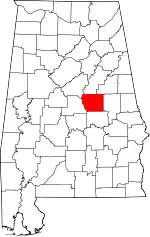 Map of Alabama highlighting Coosa County | |
| CDPs | ||
| Other unincorporated communities | ||
| Footnotes | ‡This populated place also has portions in an adjacent county or counties | |
This article is issued from Wikipedia. The text is licensed under Creative Commons - Attribution - Sharealike. Additional terms may apply for the media files.