Steinsel
Steinsel (Luxembourgish: Steesel [ˈʃteːzəl]) is a commune and town in central Luxembourg. It is located north of Luxembourg City.
Steinsel
Steesel | |
|---|---|
 | |
 Coat of arms | |
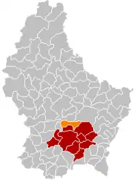
 Map of Luxembourg with Steinsel highlighted in orange, and the canton in dark red | |
| Coordinates: 49.6764°N 6.1236°E | |
| Country | |
| Canton | Luxembourg |
| Area | |
| • Total | 21.81 km2 (8.42 sq mi) |
| • Rank | 47th of 102 |
| Highest elevation | 373 m (1,224 ft) |
| • Rank | 71st of 102 |
| Lowest elevation | 241 m (791 ft) |
| • Rank | 47th of 102 |
| Population (2023) | |
| • Total | 5,539 |
| • Rank | 27th of 102 |
| • Density | 250/km2 (660/sq mi) |
| • Rank | 31st of 102 |
| Time zone | UTC+1 (CET) |
| • Summer (DST) | UTC+2 (CEST) |
| LAU 2 | LU0000308 |
| Website | steinsel.lu |
As of 2005, the town of Steinsel, which lies in the west of the commune, has a population of 1,844. Other towns within the commune include Heisdorf and Mullendorf.
Like most of Luxembourg, Steinsel has an oceanic climate. On 25 July 2019, Steinsel recorded a temperature of 40.8 °C (105.4 °F), which is the highest temperature to have ever been recorded in Luxembourg.[1]

The church of Steinsel
Population
References
- "40,8 °C: Neuer offizieller Temperaturrekord in Luxemburg" [40.8 °C: New official temperature record in Luxembourg] (in German). AgriMeteo. Archived from the original on 26 July 2019. Retrieved 25 July 2019.
- "Population par canton et commune". statistiques.public.lu. Retrieved 11 January 2022.
This article is issued from Wikipedia. The text is licensed under Creative Commons - Attribution - Sharealike. Additional terms may apply for the media files.
