Stehanja Vas
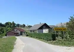
Stehanja Vas (pronounced [stɛˈxaːnja ˈʋaːs]; Slovene: Stehanja vas, German: Stockendorf[2]) is a small village in the Municipality of Trebnje in eastern Slovenia. It lies south of Veliki Gaber, south of the Slovenian A2 motorway. The area is part of the historical region of Lower Carniola. The municipality is now part of the Southeast Slovenia Statistical Region.[3]
Stehanja Vas | |
|---|---|
 | |
 Stehanja Vas Location in Slovenia | |
| Coordinates: 45°54′54.77″N 14°55′23.87″E | |
| Country | |
| Traditional region | Lower Carniola |
| Statistical region | Southeast Slovenia |
| Municipality | Trebnje |
| Area | |
| • Total | 2.49 km2 (0.96 sq mi) |
| Elevation | 423.7 m (1,390.1 ft) |
| Population (2002) | |
| • Total | 44 |
| [1] | |
Name
Stehanja Vas was attested in historical sources in 1228 as Stoychornsdorf, in 1406 as Stocheindorff, and in 1460 as Stochendarff.[4][5] The name of the village comes from the nickname Stehan, a contraction of *Stojehan, thus meaning 'Stehan's village', referring to an early inhabitant of the settlement.[4]
Church

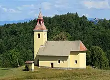
The local church, built north of the village, is dedicated to the Exaltation of the Holy Cross and belongs to the Parish of Šentlovrenc. It is a well-preserved example of Gothic architecture dating to the mid-15th century with few alterations.[6]
References
- Statistical Office of the Republic of Slovenia
- Leksikon občin kraljestev in dežel zastopanih v državnem zboru, vol. 6: Kranjsko. 1906. Vienna: C. Kr. Dvorna in Državna Tiskarna, p. 102.
- Trebnje municipal site
- Snoj, Marko (2009). Etimološki slovar slovenskih zemljepisnih imen. Ljubljana: Modrijan. pp. 394–395.
- "Slovenska historična topografija". Retrieved January 23, 2020.
- "EŠD 2472". Registry of Immovable Cultural Heritage (in Slovenian). Ministry of Culture of the Republic of Slovenia. Retrieved 9 February 2011.
External links
 Media related to Stehanja Vas at Wikimedia Commons
- Stehanja Vas on Geopedia
