State Road 25 (Serbia)
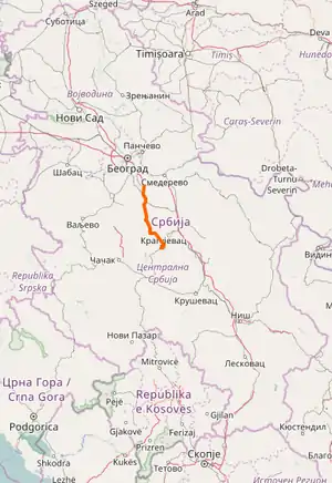
State Road 25 is an IB-class road in northern and central Serbia, connecting Mali Požarevac with Kragujevac. It is located in Belgrade and Šumadija and Western Serbia regions.[1]
 | ||||
|---|---|---|---|---|
| Serbian: Državni put IB reda 25 Serbian Cyrillic: Државни пут IБ реда 25 | ||||
 | ||||
| Route information | ||||
| Maintained by JP "Putevi Srbije" | ||||
| Length | 74.816 km (46.489 mi) | |||
| Major junctions | ||||
| From | Mali Požarevac | |||
| To | Kragujevac | |||
| Location | ||||
| Country | Serbia | |||
| Districts | City of Belgrade, Šumadija | |||
| Highway system | ||||
| ||||
Before the new road categorization regulation given in 2013, the route wore the following names: M 23 (before 2012) / 16 (after 2012).[2][3]
The existing route is a main road with two traffic lanes. By the valid Space Plan of Republic of Serbia the road is not planned for upgrading to motorway, and is expected to be conditioned in its current state.[4]
Sections
| Section number | Length | Distance | Section name |
|---|---|---|---|
| 02501 | 0.750 km (0.466 mi) | 0.750 km (0.466 mi) | Mali Požarevac interchange - Mali Požarevac |
| 02502 | 7.688 km (4.777 mi) | 8.438 km (5.243 mi) | Mali Požarevac - Vlaško Polje |
| 02503 | 5.991 km (3.723 mi) | 14.429 km (8.966 mi) | Vlaško Polje - Mladenovac (Dubona) |
| 02504 | 2.093 km (1.301 mi) | 16.522 km (10.266 mi) | Mladenovac (Dubona) - Mladenovac |
| 02505 | 5.114 km (3.178 mi) | 21.636 km (13.444 mi) | Mladenovac - Međulužje |
| 02506 | 12.506 km (7.771 mi) | 34.142 km (21.215 mi) | Međulužje - Krćevac |
| 02507 | 4.515 km (2.805 mi) | 38.657 km (24.020 mi) | Krćevac - Topola (overlap with |
| 02508 | 1.034 km (0.642 mi) | 39.691 km (24.663 mi) | Topola - Topola (Natalinci) (overlap with |
| 02509 | 11.338 km (7.045 mi) | 51.029 km (31.708 mi) | Topola (Natalinci) - Gornja Trnava |
| 02510 | 3.193 km (1.984 mi) | 54.222 km (33.692 mi) | Gornja Trnava - Vlakča |
| 02511 | 12.361 km (7.681 mi) | 66.583 km (41.373 mi) | Vlakča - Cerovac |
| 02512 | 8.233 km (5.116 mi) | 74.816 km (46.489 mi) | Cerovac - Kragujevac (Cerovac) |
See also
References
- "Republic of Serbia - national road network" (PDF). Putevi Srbije (in Serbian).
- "National road categorization regulation - Official Gazette of Republic of Serbia no. 105/2013 and 119/2013" (PDF). Serbian Spatial Planners Association (in Serbian).
- "Link between actual and previous section and road markings" (PDF). Putevi Srbije (in Serbian).
- Space plan of Republic of Serbia from 2010 to 2021
External links
This article is issued from Wikipedia. The text is licensed under Creative Commons - Attribution - Sharealike. Additional terms may apply for the media files.