Speke railway station
Speke railway station was located on East side of Woodend Avenue on the southeastern edge of Liverpool, England.
Speke Railway Station | |
|---|---|
| General information | |
| Location | Speke, Liverpool England |
| Coordinates | 53.35342°N 2.85181°W |
| Grid reference | SJ434844 |
| Platforms | 4[1][2] |
| Other information | |
| Status | Disused |
| History | |
| Original company | St Helens Railway |
| Pre-grouping | LNWR |
| Post-grouping | London Midland and Scottish Railway |
| Key dates | |
| September 1852 | Opened |
| 22 September 1930 | Closed |
History
The station opened in September 1852 and closed on 22 September 1930.[3]
By 1938 no trace of the platforms could be seen.[4]
| Preceding station | Following station | |||
|---|---|---|---|---|
| Church Road Garston | St Helens Railway | Hale Bank | ||
| Allerton | St Helens Railway | |||
References
- Gell 1985.
- Paul 1997, pp. 9 & 10.
- The station's history Disused Stations
- Fields, Gilbert & Knight 1980, Photo 246.
General references
- Fields, N; Gilbert, A C; Knight, N R (1980), Liverpool to Manchester into the Second Century, Manchester Transport Museum Society, ISBN 978-0-900857-19-5
- Gell, Rob (1985). An Illustrated Survey of Liverpool's Railway Stations 1830-1985. Crosby, Merseyside: Heyday. ISBN 978-0-947562-03-8.
- Paul, David (1997). The Archive Photo Series Around Speke. Chalford: Chalford. ISBN 978-0-7524-0798-2.
External links
- The station and local lines on multiple maps Rail Maps Online
- The station on a 25" Edwardian OS Map National Library of Scotland
- The station on line WJL2, with mileages Railway Codes
Closed railway stations in Merseyside | ||
|---|---|---|
| Birkenhead Railway | 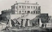    .jpg.webp) | |
| Canada Dock Branch | ||
| Cheshire Lines Committee | ||
| Chester and Birkenhead Railway | ||
| Lancashire Union Railway | ||
| Liverpool and Manchester Railway | ||
| Liverpool, Crosby and Southport Railway | ||
| Liverpool Overhead Railway | ||
| Liverpool, Southport and Preston Junction Railway | ||
| Liverpool, St Helens and South Lancashire Railway | ||
| Manchester and Southport Railway | ||
| Mersey Docks and Harbour Board | ||
| North Mersey Branch | ||
| North Wales and Liverpool Railway | ||
| St Helens and Runcorn Gap Railway | ||
| West Lancashire Railway | ||
| Wirral Railway | ||
| Other | ||
This article is issued from Wikipedia. The text is licensed under Creative Commons - Attribution - Sharealike. Additional terms may apply for the media files.