South Ogan Komering Ulu Regency
South Ogan Komering Ulu Regency (Kabupaten Ogan Komering Ulu Selatan) is an inland regency in the far south of South Sumatra Province, Indonesia. It was created on 18 December 2003 from what had previously been the southernmost districts of Ogan Komering Ulu Regency. It covers an area of 5,493.94 km2, and had a population of 318,428 at the 2010 Census[2] and 408,981 at the 2020 Census;[3] the official estimate as at mid 2022 was 426,687.[1] The administrative centre is the town of Muaradua[4] (not to be confused with Muara Dua District in Lhokseumawe City, Aceh Province). It borders Ogan Komering Ulu Regency, East Ogan Komering Ulu Regency and Muara Enim Regency to the north.[4] It also borders Lampung Province to the south and east and Bengkulu Province to the west.
South Ogan Komering Ulu Regency
(Kabupaten Ogan Komering Ulu Selatan) | |
|---|---|
 Coat of arms | |
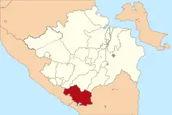 Location in South Sumatra | |
| Country | Indonesia |
| Province | South Sumatra |
| Regency seat | Muaradua |
| Area | |
| • Total | 5,493.94 km2 (2,121.22 sq mi) |
| Population (mid 2022 estimate)[1] | |
| • Total | 426,687 |
| • Density | 78/km2 (200/sq mi) |
| Time zone | UTC+7 (WIB) |
Administrative districts
The Regency is administratively composed of nineteen districts (kecamatan). Their areas (in km2) and their populations at the 2010 Census[2] and 2020 Census[3] are listed below (population estimates for 2022 are not yet published). The table also includes the locations of the district administrative centres, and the number of administrative villages in each district (totaling 252 rural desa and 7 urban kelurahan - the latter including 5 in Muasadua District, plus the administrative centres of Banding Agung and Central BPR Ranau Districts).
| Name of District (kecamatan) | Area in km2 | Pop'n Census 2010 | Pop'n Census 2020 | Admin centre | No. of villages |
|---|---|---|---|---|---|
| Mekakau Ilir | 261.15 | 17,824 | 23,917 | Tanjung Besar | 15 |
| Banding Agung | 276.38 | 18,710 | 25,955 | Bandar Agung Ranau | 22 |
| Warkuk Ranau Selatan (South Warkuk Ranau) | 239.48 | 20,486 | 25,032 | Kota Baru | 16 |
| Buay Pematang Ribu Ranau Tengah (Central BPR Ranau) | 353.20 | 19,393 | 25,972 | Simpang Sender | 22 |
| Buay Pemaca | 714.52 | 37,768 | 44,880 | Kota Way | 22 |
| Simpang | 342.29 | 13,241 | 18,086 | Simpang Agung | 7 |
| Buana Pemaca | 190.10 | 12,117 | 15,907 | Jagaraga | 8 |
| Muaradua | 261.95 | 39,533 | 50,076 | Pasar Muaradua | 14 |
| Buay Rawan | 167.00 | 12,395 | 18,767 | Gunung Cahya | 11 |
| Buay Sandang Aji | 450.00 | 16,104 | 21,334 | Gunung Terang | 16 |
| Tiga Dihaji | 153.45 | 9,028 | 11,046 | Surabaya | 8 |
| Buay Runjung | 171.19 | 9,673 | 12,811 | Belambangan | 14 |
| Runjung Agung | 157.41 | 10,989 | 13,978 | Sura | 9 |
| Kisam Tinggi | 417.00 | 17,272 | 19,820 | Tenang | 19 |
| Muaradua Kisam | 219.80 | 16,583 | 20,144 | Muaradua Kisam | 18 |
| Kisam Ilir | 136.02 | 6,995 | 7,963 | Pulau Kemiling | 9 |
| Pulau Beringin | 476.51 | 22,484 | 30,375 | Pulau Beringin | 13 |
| Sindang Danau | 210.00 | 8,561 | 11,408 | Ulu Danau | 7 |
| Sungai Are (Are River) | 296.49 | 9,272 | 11,510 | Simpang Luas | 9 |
| Totals | 5,493.94 | 318,428 | 408,981 | Muaradua | 259 |
References
- Badan Pusat Statistik, Jakarta, 2023, Kabupaten Ogan Komering Ulu Selatan Dalam Angka 2023 (Katalog-BPS 1102001.1609)
- Biro Pusat Statistik, Jakarta, 2011.
- Badan Pusat Statistik, Jakarta, 2021.
- "Profile of Regency of East Ogan Komering Ulu". Indonesia Investment Coordinating Board. Retrieved 22 February 2011.
Regencies and cities of South Sumatra | ||
|---|---|---|
Capital: Palembang | ||
| Regencies | ||
| Cities | ||