South Moniteau Township, Cooper County, Missouri
South Moniteau Township is one of fourteen townships in Cooper County, Missouri, USA. As of the 2000 census, its population was 194.[1]
South Moniteau Township | |
|---|---|
 Location in Cooper County | |
| Coordinates: 38°42′45″N 92°40′17″W | |
| Country | |
| State | |
| County | Cooper |
| Area | |
| • Total | 22.41 sq mi (58.04 km2) |
| • Land | 22.39 sq mi (57.98 km2) |
| • Water | 0.02 sq mi (0.06 km2) 0.1% |
| Elevation | 833 ft (254 m) |
| Population (2000) | |
| • Total | 194 |
| • Density | 8.7/sq mi (3.3/km2) |
| Time zone | UTC-6 (CST) |
| • Summer (DST) | UTC-5 (CDT) |
| ZIP codes | 65018, 65025 |
| GNIS feature ID | 0766539 |
Geography
According to the United States Census Bureau, South Moniteau Township covers an area of 22.41 square miles (58.04 square kilometers); of this, 22.39 square miles (57.98 square kilometers, 99.9 percent) is land and 0.02 square miles (0.06 square kilometers, 0.1 percent) is water.
Adjacent townships
- North Moniteau Township (north)
- Linn Township, Moniteau County (northeast)
- Walker Township, Moniteau County (east)
- Moreau Township, Moniteau County (south)
- Willow Fork Township, Moniteau County (southwest)
- Kelly Township (west)
Cemeteries
The township contains these cemeteries: Renshaw and Smiley,
School districts
- Clarksburg C-2
- Moniteau County R-I School District
- Prairie Home R-V School District
Political districts
- Missouri's 6th congressional district
- State House District 117
- State Senate District 21
References
- United States Census Bureau 2008 TIGER/Line Shapefiles
- United States Board on Geographic Names (GNIS)
- United States National Atlas
- "U.S. Census website". Retrieved May 13, 2009.
External links
Places adjacent to South Moniteau Township, Cooper County, Missouri | |
|---|---|
Municipalities and communities of Cooper County, Missouri, United States | ||
|---|---|---|
| Cities | 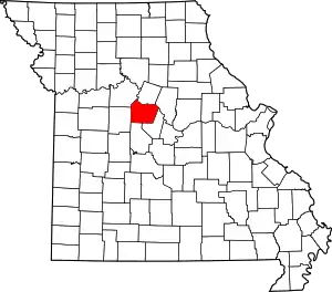 Map of Missouri highlighting Cooper County | |
| Villages | ||
| Townships | ||
| Unincorporated communities | ||
This article is issued from Wikipedia. The text is licensed under Creative Commons - Attribution - Sharealike. Additional terms may apply for the media files.