South Mills, North Carolina
South Mills is an unincorporated community and census-designated place (CDP) in Camden County, North Carolina, United States.[2] Its population was 454 as of the 2010 census.[3] South Mills has a post office with ZIP code 27976, which opened on March 2, 1840.[4][5] The community is located near U.S. Route 17, and U.S. Route 17 Business and North Carolina Highway 343, and future Interstate 87 (North Carolina) pass through the community.
South Mills, North Carolina | |
|---|---|
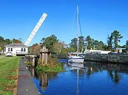 Highway bridge open for passage of sailboat at South Mills on the Intracoastal Waterway (Dismal Swamp Canal) | |
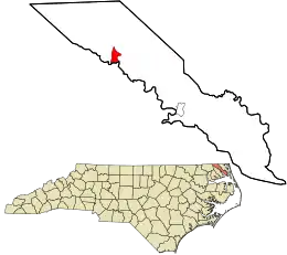 Location in Camden County and the state of North Carolina. | |
| Coordinates: 36°26′16″N 76°19′51″W | |
| Country | United States |
| State | North Carolina |
| County | Camden |
| Area | |
| • Total | 1.79 sq mi (4.64 km2) |
| • Land | 1.79 sq mi (4.64 km2) |
| • Water | 0.00 sq mi (0.00 km2) |
| Elevation | 3 ft (0.9 m) |
| Population (2020) | |
| • Total | 362 |
| • Density | 202.12/sq mi (78.05/km2) |
| Time zone | UTC-5 (Eastern (EST)) |
| • Summer (DST) | UTC-4 (EDT) |
| ZIP code | 27976 |
| Area code | 252 |
| GNIS feature ID | 2628656[2] |
| FIPS code | 37-63340 |
The community derived its name from a watermill which operated near the original town site.[6]
The William Riley Abbott House, Dismal Swamp Canal, and Morgan House are listed on the National Register of Historic Places.[7]
Demographics
| Census | Pop. | Note | %± |
|---|---|---|---|
| 2020 | 362 | — | |
| U.S. Decennial Census[8] | |||
2020 census
| Race | Number | Percentage |
|---|---|---|
| White (non-Hispanic) | 281 | 77.62% |
| Black or African American (non-Hispanic) | 50 | 13.81% |
| Asian | 2 | 0.55% |
| Other/Mixed | 25 | 6.91% |
| Hispanic or Latino | 4 | 1.1% |
As of the 2020 United States census, there were 362 people, 181 households, and 139 families residing in the CDP.
References
- "ArcGIS REST Services Directory". United States Census Bureau. Retrieved September 20, 2022.
- U.S. Geological Survey Geographic Names Information System: South Mills, North Carolina
- "Geographic Identifiers: 2010 Demographic Profile Data (G001): South Mills CDP, North Carolina". U.S. Census Bureau, American Factfinder. Archived from the original on February 12, 2020. Retrieved December 22, 2014.
- United States Postal Service (2012). "USPS - Look Up a ZIP Code". Retrieved February 15, 2012.
- "Postmaster Finder - Post Offices by ZIP Code". United States Postal Service. Retrieved March 6, 2014.
- Federal Writers' Project (1938). The Ocean Highway: New Brunswick, New Jersey to Jacksonville, Florida. Works Progress Administration. p. 92.
- "National Register Information System". National Register of Historic Places. National Park Service. July 9, 2010.
- "Census of Population and Housing". Census.gov. Retrieved June 4, 2016.
- "Explore Census Data". data.census.gov. Retrieved December 22, 2021.
Municipalities and communities of Camden County, North Carolina, United States | ||
|---|---|---|
| City |  Camden County map | |
| CDPs | ||
| Townships |
| |
| Unincorporated community | ||
| Footnotes | ‡This populated place also has portions in an adjacent county or counties | |