Snaith
Snaith is a market town and parish in the civil parish of Snaith and Cowick in the East Riding of Yorkshire, England. The town is close to the River Aire and the M62 and M18 motorways. The town is located 7 miles (11 km) west of Goole, 10 miles (16 km) east of Knottingley, 8 miles (13 km) south of Selby, 10 miles (16 km) southwest of Howden and 8 miles (13 km) northwest of Thorne.
| Snaith | |
|---|---|
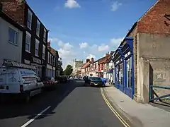 Market Place, Snaith | |
 Snaith Location within the East Riding of Yorkshire | |
| Population | 3,176 |
| OS grid reference | SE642220 |
| • London | 160 mi (260 km) SSE |
| Civil parish | |
| Unitary authority | |
| Ceremonial county | |
| Region | |
| Country | England |
| Sovereign state | United Kingdom |
| Post town | GOOLE |
| Postcode district | DN14 |
| Dialling code | 01405 |
| Police | Humberside |
| Fire | Humberside |
| Ambulance | Yorkshire |
| UK Parliament | |

The town's population is 3,176[1] while the civil parish population is 3,865.[2]
History
The name "Snaith" derives from the Old Scandinavian word sneith, meaning "piece of land cut off".[3] The name was recorded in its modern-day form in c. 1080, but in the Domesday Book of 1086 it appears as Esneid.
The priory church of St Lawrence is low and wide, with pinnacles. Its core is Norman and cruciform, but the tower, standing at the west end, is Early English. The chancel is Decorated Gothic and the nave has Perpendicular arcades and a high clerestory. Glass in the chancel window is by Francis Spear and there is a notable monument to Viscount Downe by Francis Chantrey.[4] The church was designated a Grade I listed building in 1967 and is now recorded in the National Heritage List for England, maintained by Historic England.[5]

Sport
Snaith Juniors Football Club formed in 1990 as Croda F.C. on the grounds of Cowick Hall, then used by Croda International.[6] Snaith Juniors F.C. now play at Ben Bailey housing estate and hold football tournaments at the end of May each year. The Garth, adjacent to the Methodist Chapel, was given to the people of Snaith for recreation and leisure. The town has an active cycling presence, the Marshes Cycling Club (MCC).
Town centre

Snaith town centre has a variety of amenities and many pubs and restaurants, takeaway and retail shops. The priory church is located on the western side of town and Snaith Hall is directly south of the town. The town also has Methodist church on Cowick Road, a doctor's surgery on Butt Lane, and a fire station on Market Place.[7]
Transport

Snaith railway station has limited daily services to Leeds and Goole. It has no services on Sundays. The town had stations at Snaith and Pollington on the Hull and Barnsley and Great Central Joint Railway and in the nearby village of Carlton, Carlton Towers on the Hull and Barnsley Railway. The town is also served by bus services to Selby and Goole.[8]
References
- "Snaith (East Riding of Yorkshire, Yorkshire and the Humber, United Kingdom) - Population Statistics, Charts, Map, Location, Weather and Web Information". www.citypopulation.de. Retrieved 25 November 2022.
- "Snaith and Cowick (Parish, United Kingdom) - Population Statistics, Charts, Map and Location". www.citypopulation.de. Retrieved 25 November 2022.
- Ekwall, Eilert (1960). The Concise Oxford Dictionary of English Place-Names (4 ed.). Oxford: Clarendon Press. p. 428. ISBN 0-19-869103-3.
- Betjeman, John, ed. (1968). Collins Pocket Guide to English Parish Churches: the North. London: Collins. p. 349.
- Historic England. "Church of St Lawrence (1161899)". National Heritage List for England. Retrieved 10 August 2013.
- "Snaith Juniors FC History". Snaith Juniors FC. Retrieved 23 November 2015.
- "Snaith -". East Yorkshire. Retrieved 25 November 2022.
- "Snaith – bustimes.org". bustimes.org. Retrieved 25 November 2022.
- Gazetteer — A–Z of Towns Villages and Hamlets. East Riding of Yorkshire Council. 2006. p. 10.
| Unitary authorities | |
|---|---|
| Major settlements (cities in italics) | |
| Rivers | |
| Canals | |
| Topics | |