Sierra Grande
Sierra Grande is an extinct stratovolcano in northeastern New Mexico that rises 2,200 feet above the surrounding plain. It is part of the inactive Raton-Clayton volcanic field.
| Sierra Grande | |
|---|---|
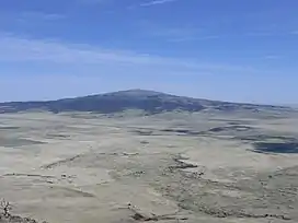
 Sierra Grande seen from the top of Capulin Volcano. | |
| Highest point | |
| Elevation | 8,723 ft (2,659 m) NAVD 88[1] |
| Prominence | 1,880 ft (570 m)[1] |
| Coordinates | 36°42′20″N 103°52′36″W[2] |
| Geography | |
| Location | Union County, New Mexico, U.S. |
| Topo map | USGS Capulin |
| Geology | |
| Mountain type | Stratovolcano |
| Volcanic field | Raton-Clayton volcanic field |
| Climbing | |
| Easiest route | Hike |
Geography
On a clear day, Sierra Grande can be seen from as far away as Texline, Texas, as well as from the summits of the Culebra Range in southern Colorado and northern New Mexico. The eastern slopes of Sierra Grande are the easternmost point in the United States with an elevation of more than 8,000 feet (2,400 m) above sea level,[3] and the peak is the highest in the United States east of 104 degrees west.
U.S. Highway 64, U.S. Highway 87 and the Colorado and Southern Railway run along the north and east of the volcano. The town of Des Moines is just to the northeast. To the northwest is Capulin Volcano National Monument featuring Capulin Volcano, an extinct cinder cone also in the Raton-Clayton volcanic field.
Numerous watercourses form on and around the flanks of the volcano, including Pinabete Creek (which feeds into the Dry Cimarron River to the northeast),[4] North Branch Corrumpa Creek[5] and South Branch Corrumpa Creek[6] (which join and become Corrumpa Creek to the east at Weatherly Lake),[7][8] Seneca Creek,[9] and Carrizo Creek.[10]
Geology
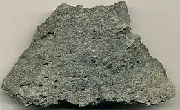
Sierra Grande is the largest volcano in the Raton-Clayton volcanic field. Its flows range in age from 3.8 to 2.6 million years. The volcano is largely composed of two-pyroxene andesite, a rock type found almost nowhere else in the Raton-Clayton volcanic field.[11]
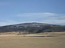
 Sierra Grande as seen from the north along US Highways 64 and 87 |
 Andesite from a 1.9 million year old lava flow, on the eastern side of Sierra Grande. |
References
- "Sierra Grande, New Mexico". Peakbagger.com. Retrieved 2013-01-26.
- "Sierra Grande". Geographic Names Information System. United States Geological Survey, United States Department of the Interior. Retrieved 2013-01-26.
- DeLorme Topo 6.0
- "Pinabete Creek". Natural Atlas. Retrieved August 18, 2021.
- "North Branch Corrumpa Creek". Natural Atlas. Retrieved August 18, 2021.
- "South Branch Corrumpa Creek". Natural Atlas. Retrieved August 18, 2021.
- "Corrumpa Creek". Natural Atlas. Retrieved August 18, 2021.
- "Beaver-Canadian-River". Where Eagles Fly. Retrieved August 18, 2021.
- "Seneca Creek". Natural Atlas. Retrieved August 18, 2021.
- "Carrizo Creek". Natural Atlas. Retrieved August 18, 2021.
- Ziegler, Kate E.; Ramos, Frank C.; Zimmerer, Matthew J. (2019). "Geology of Northeastern New Mexico, union and Colfax Counties, New Mexico: A Geologic Summary" (PDF). New Mexico Geological Society Field Conference Series. 70 (4): 47–54. Retrieved 1 September 2020.
- Wood, Charles A.; Jürgen Kienle, eds. (1990). Volcanoes of North America. Cambridge University Press. ISBN 0-521-43811-X.
- "Volcano World: Capulin Mountain and Sierra Grande". Retrieved 2007-03-26.