Shorehaven, New York
Shorehaven is a census-designated place (CDP) in the town of Pawling in Dutchess County, New York, United States. It was first listed as a CDP prior to the 2020 census.[2]
Shorehaven, New York | |
|---|---|
 Shorehaven  Shorehaven | |
| Coordinates: 41°33′24″N 73°40′2″W | |
| Country | United States |
| State | New York |
| County | Dutchess |
| Town | Pawling |
| Area | |
| • Total | 1.80 sq mi (4.67 km2) |
| • Land | 1.37 sq mi (3.55 km2) |
| • Water | 0.43 sq mi (1.11 km2) |
| Elevation | 760 ft (230 m) |
| Population (2020) | |
| • Total | 686 |
| • Density | 500.36/sq mi (193.17/km2) |
| Time zone | UTC-5 (Eastern (EST)) |
| • Summer (DST) | UTC-4 (EDT) |
| ZIP Code | 12531 (Holmes) |
| Area code | 845 |
| FIPS code | 36-67207 |
| GNIS feature ID | 2806931[2] |
Shorehaven is in southeastern Dutchess County, along the western edge of the town of Pawling. The CDP is bordered to the west by the town of Beekman. The community surrounds Whaley Lake, which drains north via Whaley Lake Stream to Fishkill Creek, a southwestward-flowing tributary of the Hudson River. New York State Route 292 runs through Shorehaven along the western side of Whaley Lake. The state highway leads north 2 miles (3 km) to NY 55 in West Pawling and southeast 6 miles (10 km) to Patterson.
References
- "ArcGIS REST Services Directory". United States Census Bureau. Retrieved September 20, 2022.
- "Shorehaven Census Designated Place". Geographic Names Information System. United States Geological Survey, United States Department of the Interior.
- "Census of Population and Housing". Census.gov. Retrieved June 4, 2016.
Municipalities and communities of Dutchess County, New York, United States | ||
|---|---|---|
| Cities | 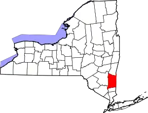 | |
| Towns | ||
| Villages | ||
| CDPs |
| |
| Other hamlets | ||
| Former communities | ||
| Footnotes | ‡This populated place also has portions in an adjacent county or counties | |
This article is issued from Wikipedia. The text is licensed under Creative Commons - Attribution - Sharealike. Additional terms may apply for the media files.