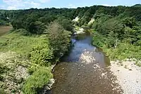
Shiribeshi-Toshibetsu River
Shiribeshi-Toshibetsu River (後志利別川, Shiribeshi-Toshibetsu-gawa) is a Class A river in Hokkaidō, Japan. It flows through Hiyama District, and empties into the Sea of Japan.[1]
| Shiribeshi-Toshibetsu River 後志利別川 | |
|---|---|
 Looking downstream from the Majo Bridge | |
| Native name | Shiribeshi-Toshibetsu-gawa (Japanese) |
| Location | |
| Country | Japan |
| State | Hokkaidō |
| Region | Hiyama |
| District | Kudō District, Setana |
| Municipalities | Imakane, Setana |
| Physical characteristics | |
| Source | Mount Oshamanbe |
| • location | Imakane, Hokkaidō, Japan |
| • coordinates | 42°35′9″N 140°11′22″E |
| • elevation | 972.6 m (3,191 ft) |
| Mouth | Sea of Japan |
• location | Setana, Hokkaidō, Japan |
• coordinates | 42°25′30″N 139°50′33″E |
• elevation | 0 m (0 ft) |
| Length | 80 km (50 mi) |
| Basin size | 720 km2 (280 sq mi) |
| Discharge | |
| • average | 27.55 m3/s (973 cu ft/s) |
It is the only Class A river in Southern Hokkaidō, and thus is considered to be extremely important for agriculture and flood control.[2]
The river has been voted the "Cleanest River in Japan" by the Ministry of Land, Infrastructure, Transport and Tourism (MLIT) 10 times between 1987 and 2006.[3][2]
Geography
The Shiribeshi-Toshibetsu river originates from the ridge between Mount Taihei and Mount Oshamambe-dake. Its catchment area is 720 square kilometres (280 sq mi) and its stream length is 80 kilometres (50 mi). The river flows through Imakane, Setana. and Kitahiyama, Hokkaido.[3][2]
Climate
The basin is located at the northern limit of the temperate climate and is relatively warm due to the influence of the Tsushima Current moving northward across the Sea of Japan.[3]
Origin of name
The name Shiribeshi-Toshibetsu was formed by adding the word Shiribeshi to distinguish the river from the Toshibetsu River in Tokachi Subprefecture. Shiribeshi was the name of a province which existed between 1869 and 1882. The name Toshibetsu is thought to originate from the Ainu words toshu betsu, meaning 'meandering river', or to ushi betsu, meaning 'river with many marshes'.[2]
References
- 北海道開発局, 国土交通省. "後志利別川". 北海道開発局 (in Japanese). Retrieved 2021-10-16.
- "Shiribeshitoshibetsu River - Outline of Flood Control Projects" (PDF).
- "後志利別川 / 檜山を旅しよう - 檜山振興局産業振興部商工労働観光課". www.hiyama.pref.hokkaido.lg.jp. Retrieved 2021-10-16.