Shire of Toodyay
The Shire of Toodyay is a local government area in the Wheatbelt region of Western Australia, beyond the north-eastern limits of the Perth metropolitan area. The Shire covers an area of 1,694 square kilometres (654 sq mi), and its seat of government is the town of Toodyay.
| Shire of Toodyay Western Australia | |||||||||||||||
|---|---|---|---|---|---|---|---|---|---|---|---|---|---|---|---|
.jpg.webp) The Toodyay Council offices | |||||||||||||||
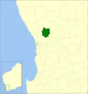 Location in Western Australia | |||||||||||||||
| Population | 4,601 (LGA 2021)[1] | ||||||||||||||
| Established | 1871 | ||||||||||||||
| Area | 1,693.8 km2 (654.0 sq mi) | ||||||||||||||
| Shire President | Rosemary Madácsi | ||||||||||||||
| Council seat | Toodyay | ||||||||||||||
| Region | Wheatbelt | ||||||||||||||
| State electorate(s) | Moore | ||||||||||||||
| Federal division(s) | Pearce | ||||||||||||||
| Website | Shire of Toodyay | ||||||||||||||
| |||||||||||||||
History
The Toodyay Road District was established on 24 January 1871. The Newcastle (later Toodyay) townsite separated as the Municipality of Newcastle on 2 October 1877. The municipality merged back into the road district on 8 March 1912. On 1 July 1961, Toodyay became a shire under the Local Government Act 1960, which reformed all remaining road districts into shires.[2]
Wards
The Shire has been divided into 4 wards, since the Toodyay Road board meeting in June 1904.[3]
- North Ward (2 councillors)
- Central Ward (2 councillors)
- West Ward (3 councillors)
- East Ward (2 councillors)
Towns and localities
The towns and localities of the Shire of Toodyay with population and size figures based on the most recent Australian census:[4][5]
| Locality | Population | Area | Map |
|---|---|---|---|
| Bejoording | 157 (SAL 2021)[6] | 88.7 km2 (34.2 sq mi) | |
| Bindoon Defence Training Area | 0 (SAL 2016)[7][8] | 137.4 km2 (53.1 sq mi) | |
| Coondle | 664 (SAL 2021)[9] | 68 km2 (26 sq mi) | |
| Culham | 26 (SAL 2021)[10] | 90.7 km2 (35.0 sq mi) | |
| Dewars Pool | 82 (SAL 2021)[11] | 86.7 km2 (33.5 sq mi) | |
| Dumbarton | 266 (SAL 2021)[12] | 71.7 km2 (27.7 sq mi) | |
| Hoddys Well | 140 (SAL 2021)[13] | 76.9 km2 (29.7 sq mi) | |
| Julimar | 406 (SAL 2021)[14] | 343.5 km2 (132.6 sq mi) | |
| Moondyne | 0 (SAL 2021)[15] | 94.5 km2 (36.5 sq mi) | |
| Morangup | 751 (SAL 2021)[16] | 202.9 km2 (78.3 sq mi) | |
| Nunile | 183 (SAL 2021)[17] | 118.1 km2 (45.6 sq mi) | |
| Toodyay | 1,362 (SAL 2021)[18] | 62.4 km2 (24.1 sq mi) | |
| Wattening | 61 (SAL 2021)[19] | 190.6 km2 (73.6 sq mi) | |
| West Toodyay | 497 (SAL 2021)[20] | 59.7 km2 (23.1 sq mi) |
Presidents
Population
|
|
Heritage-listed places
As of 2023, 173 places are heritage-listed in the Shire of Toodyay,[21] of which 16 are on the State Register of Heritage Places.[22]
See also
- Wikipedia:WikiTown/Toodyaypedia
References
- Australian Bureau of Statistics (28 June 2022). "Toodyay (Local Government Area)". Australian Census 2021 QuickStats. Retrieved 28 June 2022.
- "Municipality Boundary Amendments Register" (PDF). Western Australian Electoral Distribution Commission. Retrieved 11 January 2020.
- "Newcastle". Western Mail (Perth, WA : 1885 - 1954). Perth, WA: National Library of Australia. 4 June 1904. p. 18. Retrieved 4 March 2014.
- "SLIP Map". maps.slip.wa.gov.au. Landgate. Retrieved 13 February 2023.
- "NationalMap". nationalmap.gov.au. Geoscience Australia. Retrieved 13 February 2023.
- Australian Bureau of Statistics (28 June 2022). "Bejoording (Suburb and Locality)". Australian Census 2021 QuickStats. Retrieved 28 June 2022.
- Australian Bureau of Statistics (27 June 2017). "Bindoon Defence Training Area (Suburb and Locality)". Australian Census 2016.
- Australian Bureau of Statistics (27 June 2017). "Bindoon Training Area (Suburb and Locality)". Australian Census 2016 QuickStats. Retrieved 28 June 2022.
- Australian Bureau of Statistics (28 June 2022). "Coondle (Suburb and Locality)". Australian Census 2021 QuickStats. Retrieved 28 June 2022.
- Australian Bureau of Statistics (28 June 2022). "Culham (Suburb and Locality)". Australian Census 2021 QuickStats. Retrieved 28 June 2022.
- Australian Bureau of Statistics (28 June 2022). "Dewars Pool (Suburb and Locality)". Australian Census 2021 QuickStats. Retrieved 28 June 2022.
- Australian Bureau of Statistics (28 June 2022). "Dumbarton (Suburb and Locality)". Australian Census 2021 QuickStats. Retrieved 28 June 2022.
- Australian Bureau of Statistics (28 June 2022). "Hoddys Well (Suburb and Locality)". Australian Census 2021 QuickStats. Retrieved 28 June 2022.
- Australian Bureau of Statistics (28 June 2022). "Julimar (Suburb and Locality)". Australian Census 2021 QuickStats. Retrieved 28 June 2022.
- Australian Bureau of Statistics (28 June 2022). "Moondyne (Suburb and Locality)". Australian Census 2021 QuickStats. Retrieved 28 June 2022.
- Australian Bureau of Statistics (28 June 2022). "Morangup (Suburb and Locality)". Australian Census 2021 QuickStats. Retrieved 28 June 2022.
- Australian Bureau of Statistics (28 June 2022). "Nunile (Suburb and Locality)". Australian Census 2021 QuickStats. Retrieved 28 June 2022.
- Australian Bureau of Statistics (28 June 2022). "Toodyay (Suburb and Locality)". Australian Census 2021 QuickStats. Retrieved 28 June 2022.
- Australian Bureau of Statistics (28 June 2022). "Wattening (Suburb and Locality)". Australian Census 2021 QuickStats. Retrieved 28 June 2022.
- Australian Bureau of Statistics (28 June 2022). "West Toodyay (Suburb and Locality)". Australian Census 2021 QuickStats. Retrieved 28 June 2022.
- "Shire of Toodyay Heritage Places". inherit.stateheritage.wa.gov.au. Heritage Council of Western Australia. Retrieved 25 February 2023.
- "Shire of Toodyay State Register of Heritage Places". inherit.stateheritage.wa.gov.au. Heritage Council of Western Australia. Retrieved 25 February 2023.