Self-administered zone
A self-administered zone is an administrative subdivision in Myanmar (Burma). There are five self-administered zones and one self-administered division.
| Administrative divisions of Myanmar |
|---|
| First-level |
| Second-level |
| Third-level |
| Fourth-level |
| Fifth-level |
Self-administered zones and self-administered division
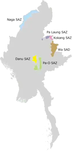
Self-Administered Zones and Self-Administered Division
| Flag | Name | Burmese | Capital | Region | Population | Area (km2) | Type |
|---|---|---|---|---|---|---|---|
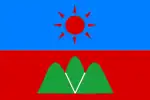
 |
Danu Self-Administered Zone | ဓနုကိုယ်ပိုင်အုပ်ချုပ်ခွင့်ရဒေသ | Pindaya | Shan State | 161,835[1] | Self-Administered Zone | |
 |
Kokang Self-Administered Zone | ကိုးကန့်ကိုယ်ပိုင်အုပ်ချုပ်ခွင့်ရဒေသ | Laukkai | Shan State | 123,733[1] | Self-Administered Zone | |
 |
Naga Self-Administered Zone | နာဂကိုယ်ပိုင်အုပ်ချုပ်ခွင့်ရဒေသ | Lahe | Sagaing Region | Self-Administered Zone | ||
 |
Pa Laung Self-Administered Zone | ပလောင်းကိုယ်ပိုင်အုပ်ချုပ်ခွင့်ရဒေသ | Namhsan | Shan State | Self-Administered Zone | ||
 |
Pa'O Self-Administered Zone | ပအိုဝ့်ကိုယ်ပိုင်အုပ်ချုပ်ခွင့်ရဒေသ | Hopong | Shan State | Self-Administered Zone | ||
 |
Wa Self-Administered Division | ဝကိုယ်ပိုင်အုပ်ချုပ်ခွင့်ရတိုင်း | Hopang | Shan State | Self-Administered Division |
References
- Shan State. The 2014 Myanmar Population and Housing Census. Vol. 3-M. Naypyitaw: Ministry of Immigration and Population. May 2015. p. 16.
This article is issued from Wikipedia. The text is licensed under Creative Commons - Attribution - Sharealike. Additional terms may apply for the media files.