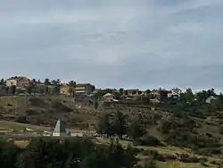
Santa María de la Alameda
Santa María de la Alameda (Spanish pronunciation: [ˈsanta maˈɾi.a ðe la alaˈmeða]) is a municipality of the Community of Madrid, Spain. It is linked to the city of Madrid and the town of El Escorial by regular train services. A popular weekend and holiday destination, Santa Maria is popular with anglers, hunters, walkers and outdoors enthusiasts.
Santa María de la Alameda | |
|---|---|
 | |
 Flag  Coat of arms | |
_mapa.svg.png.webp) | |
| Country | Spain |
| Region | Community of Madrid |
| Area | |
| • Total | 74.41 km2 (28.73 sq mi) |
| Elevation | 1,409 m (4,623 ft) |
| Population (2018)[1] | |
| • Total | 1,182 |
| • Density | 16/km2 (41/sq mi) |
| Time zone | UTC+1 (CET) |
| • Summer (DST) | UTC+2 (CEST) |
Originally a group of cattle-raising hamlets, the municipality comprises different settlements: Las Herreras, El Pimpollar, La Hoya, Navalespino, La Paradilla, Robledondo, Santa María de la Alameda and Santa María Estación.[2] In time, the nucleus of "Santa María Estación", developed around the railway station, has grown to become the most populated settlement.[3] The capital of the municipality (the namesake "Santa María de la Alameda") is located at an elevation of 1,409 metres.[4] The municipality covers an area of 74.41 km2,[5] including the exclave of Dehesa de la Cepeda, a mostly pasture area geographically located between the provinces of Ávila and Segovia in the autonomous community of Castile and León.
References
- Municipal Register of Spain 2018. National Statistics Institute.
- "Santa María de la Alameda". Madridiario. 9 October 2007.
- Unceta, María; Echenagusia, Javier (2006). Madrid. Guía turística del Canal de Isabel II. La Sierra del Agua (PDF). Santillana Ediciones Generales. p. 209.
- "Predicción por municipios. Santa María de la Alameda (Madrid)". AEMET.
- "Municipios". Datos del Registro de Entidades Locales. Ministerio de Hacienda y Administraciones Públicas.