Sankt Leonhard im Pitztal
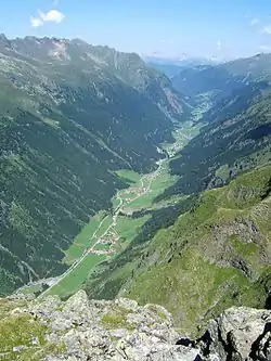
Sankt Leonhard im Pitztal is a municipality in the Imst district, located 20 kilometres (12 mi) south of Imst on the upper course of the Pitze River in western Austria. The village covers a large area and has a length of around 25 kilometres (16 mi). It is one of the biggest communities of Tyrol by area.
St. Leonhard im Pitztal | |
|---|---|
 | |
 Coat of arms | |
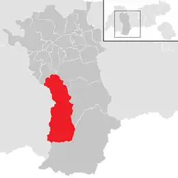 Location in the district | |
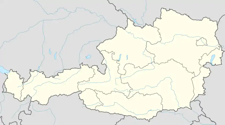 St. Leonhard im Pitztal Location within Austria | |
| Coordinates: 47°04′00″N 10°50′00″E | |
| Country | Austria |
| State | Tyrol |
| District | Imst |
| Government | |
| • Mayor | Rupert Hosp |
| Area | |
| • Total | 223.53 km2 (86.31 sq mi) |
| Elevation | 1,366 m (4,482 ft) |
| Population (2018-01-01)[2] | |
| • Total | 1,382 |
| • Density | 6.2/km2 (16/sq mi) |
| Time zone | UTC+1 (CET) |
| • Summer (DST) | UTC+2 (CEST) |
| Postal code | 6481 |
| Area code | 05413 |
| Vehicle registration | IM |
| Website | www.st-leonhard.tirol.gv.at |
The climate is severe because of mountain flanks. The area was founded around 1300, and its main source of income is tourism.
Climate
| Climate data for St.Leonhard Pitztal: 1454m (1991−2020) | |||||||||||||
|---|---|---|---|---|---|---|---|---|---|---|---|---|---|
| Month | Jan | Feb | Mar | Apr | May | Jun | Jul | Aug | Sep | Oct | Nov | Dec | Year |
| Record high °C (°F) | 11.7 (53.1) |
13.4 (56.1) |
18.8 (65.8) |
21.6 (70.9) |
25.8 (78.4) |
31.2 (88.2) |
30.3 (86.5) |
29.3 (84.7) |
24.8 (76.6) |
22.3 (72.1) |
19.2 (66.6) |
12.3 (54.1) |
31.2 (88.2) |
| Average high °C (°F) | 0.9 (33.6) |
2.7 (36.9) |
6.0 (42.8) |
10.1 (50.2) |
14.3 (57.7) |
18.2 (64.8) |
19.3 (66.7) |
18.8 (65.8) |
15.3 (59.5) |
11.1 (52.0) |
5.5 (41.9) |
1.3 (34.3) |
10.3 (50.5) |
| Daily mean °C (°F) | −4.7 (23.5) |
−3.7 (25.3) |
0.2 (32.4) |
4.0 (39.2) |
8.6 (47.5) |
12.0 (53.6) |
13.8 (56.8) |
13.4 (56.1) |
9.5 (49.1) |
5.5 (41.9) |
0.3 (32.5) |
−3.8 (25.2) |
4.6 (40.3) |
| Average low °C (°F) | −9.5 (14.9) |
−10.2 (13.6) |
−5.4 (22.3) |
−1.8 (28.8) |
2.4 (36.3) |
5.8 (42.4) |
7.4 (45.3) |
7.3 (45.1) |
4.0 (39.2) |
0.1 (32.2) |
−4.5 (23.9) |
−8.0 (17.6) |
−1.0 (30.1) |
| Record low °C (°F) | −23.6 (−10.5) |
−28.4 (−19.1) |
−25.2 (−13.4) |
−15.9 (3.4) |
−6.8 (19.8) |
−2.7 (27.1) |
−0.5 (31.1) |
−1.0 (30.2) |
−5.3 (22.5) |
−14.2 (6.4) |
−18.4 (−1.1) |
−22.3 (−8.1) |
−28.4 (−19.1) |
| Source: Central Institute for Meteorology and Geodynamics[3] | |||||||||||||
Population
| Year | Pop. | ±% |
|---|---|---|
| 1869 | 1,147 | — |
| 1880 | 1,057 | −7.8% |
| 1890 | 1,039 | −1.7% |
| 1900 | 986 | −5.1% |
| 1910 | 1,032 | +4.7% |
| 1923 | 932 | −9.7% |
| 1934 | 983 | +5.5% |
| 1939 | 989 | +0.6% |
| 1951 | 1,042 | +5.4% |
| 1961 | 1,150 | +10.4% |
| 1971 | 1,224 | +6.4% |
| 1981 | 1,299 | +6.1% |
| 1991 | 1,404 | +8.1% |
| 2001 | 1,472 | +4.8% |
| 2011 | 1,463 | −0.6% |
References
- "Dauersiedlungsraum der Gemeinden Politischen Bezirke und Bundesländer - Gebietsstand 1.1.2018". Statistics Austria. Retrieved 10 March 2019.
- "Einwohnerzahl 1.1.2018 nach Gemeinden mit Status, Gebietsstand 1.1.2018". Statistics Austria. Retrieved 9 March 2019.
- "Klimamittelwerte 1991-2020" (in German). Central Institute for Meteorology and Geodynamics. Retrieved 21 August 2023.
External links
Wikimedia Commons has media related to St. Leonhard im Pitztal.
- www.st-leonhard.tirol.gv.at - city website
This article is issued from Wikipedia. The text is licensed under Creative Commons - Attribution - Sharealike. Additional terms may apply for the media files.