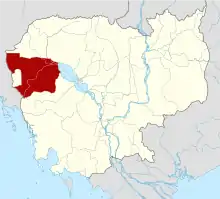
Sangkae District
Sangkae District (Khmer: ស្រុកសង្កែ) is a district (srok) within Battambang Province, in north-western Cambodia. The Sangkae river gives its name to the district.
Sangkae District
ស្រុកសង្កែ | |
|---|---|
| Country | |
| Province | Battambang |
| Population (1998)[1] | |
| • Total | 106,267 |
| Time zone | UTC+7 (ICT) |
Administration
The district is subdivided into 10 communes (khum).[2]
Communes and villages
| Khum (Commune) | Phum (Villages) |
|---|---|
| Anlong Vil | Chrab Veal, Beng, Anlong Vil, O Muni Muoy, O Muni Pir, Chumnik, Puk Chhma, Spong, Svay Kang |
| Norea | Norea Muoy, Norea Pi, Balat, Ta Kok |
| Ta Pon | Boeng Tuem, Svay Sa, Samdach, Basaet, Ta Pon |
| Roka | Chhung Tradak, Pou Battambang, Ambaeng Thngae, Roka, Ta Haen Muoy, Ta Haen Pi |
| Kampong Preah | Prey Chaek, Panhnha, Kralanh, Kampong Preah, Andoung Trach, Srah Kaev |
| Kampong Preang | Sambok Ak, Sala Trav, Kach Roteh, Thmei, Os Touk, Kbal Thnal |
| Reang Kesei | Tuol Snuol, Wat Kandal, Reang Kesei, Reang Kraol, Prey Svay, Svay Cheat, Boeng Veaeng, Damnak Dangkao, Kakaoh Kambot |
| O Dambang Muoy | Wat Ta Meum, Baoh Pou, O Khcheay, O Sralau, Wat Chaeng, Samraong Kaong |
| O Dambang Pi | O Dambang, Svay Chrum, Kampong Mdaok, Svay Thum, Dampouk Khpos, Tuol Lveang |
| Wat Ta Meum | Kampong Ampil, Kampong Chlang, O Sralau, O Khcheay, Sla Kram, Anlong Lvea |
References
- General Population Census of Cambodia, 1998: Village Gazetteer. National Institute of Statistics. February 2000. pp. 27–28.
- Statistics of the Cambodian Government Archived 2008-12-24 at the Wayback Machine
This article is issued from Wikipedia. The text is licensed under Creative Commons - Attribution - Sharealike. Additional terms may apply for the media files.
