Saint Michael, Barbados
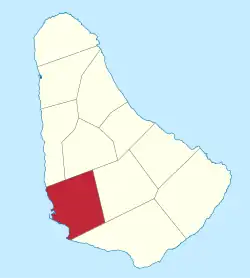
The parish of St. Michael is one of eleven parishes of Barbados. It has a land area of 39 km2 (15 sq mi) and is found at the southwest portion of the island. Saint Michael has survived by name as one of the original six parishes created in 1629 by Governor Sir William Tufton.
Saint Michael | |
|---|---|
 Map of Barbados showing Saint Michael | |
| Coordinates: 13°07′05″N 59°36′11″W | |
| Country | |
| Largest city | Bridgetown |
| Government | |
| • Type | Parliamentary democracy |
| • Parliamentary seats | 11 |
| Area | |
| • Total | 39 km2 (15 sq mi) |
| Population (2010 census) | |
| • Total | 88,529 |
| • Density | 2,300/km2 (5,900/sq mi) |
| ISO 3166 code | BB-08[1] |
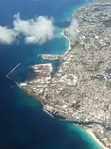
The parish is home to Bridgetown, the capital of Barbados. Bridgetown is the centre of commercial activity in Barbados, as well as a central hub for the public transport network. Other major infrastructure in St. Michael is the international seaport of Barbados—the Deep Water Harbour. Therein, a number of cruise ships arrive and depart including various lines such as Royal Caribbean and Cunard. The harbour features several sugar towers for loading locally produced sugar into transport ships, and a tower for loading flour for transport.

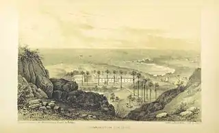
The Needham's Point Lighthouse and Charles Fort are both located in Needham's Point, Saint Michael, behind the Hilton Barbados Resort.
Under Barbados's historical vestry system, the main parish church (St Michael's Cathedral) is sited in St Michael's Row in Bridgetown. The cathedral replaced the former parish church that was located at the site of St Mary's Church. St Michael's Cathedral was elevated to cathedral status under Bishop Coleridge, who arrived in Barbados in 1825 to head the newly created Diocese of Barbados and the Leeward Islands.
Geography
Populated places
The parish contains the following towns, villages, localities, settlements, communities and hamlets:
- Airlie
- Airlie Heights
- Airlie Tenantry
- Bank Hall
- Barbarees Gardens
- Barbarees Hill
- Baxter's Road
- Batts Rock Bay
- Bay Street
- Bayville
- Beckles Road
- Belfield
- Belle
- Belle Road
- Belleville
- Belmont Road
- BET Hill
- Bibby's Lane
- Bishop's Court Hill
- Black Rock
- Brandons Beach
- Brandons Road
- Bridge Road
- Bridgetown (110,000) -- Capital
- Bridgetown Harbour
- Brighton
- Brighton Beach
- Brighton Hill
- Brighton Road
- Brighton Terrace
- Brittons New Road
- Brittons Hill
- Brownes Beach
- Bush Hall
- Bush Hall Main Road
- Bush Hall Yard Gap
- Canewood
- Canewood Road
- Carlisle Bay
- Carrington Village
- Cave Hill
- Chapman Street
- Cheapside Road
- Chelsea Road
- Clapham
- Clermont
- Clermont Road
- Clermont Terrace
- Clevedale
- Codrington
- Codrington Road
- Collymore Rock
- Constitution Road
- Country Road
- Crumpton Street
- Culloden Road
- Cypress Street
- Dalkeith
- Dalkeith Hill
- Dalkeith Road
- Dayrells
- Deacons
- Deacons Court
- Deacons Road
- Deacons Farm
- Deighton Road
- Drill Hall
- Drill Hall Beach
- Eagle Hall
- Eden Lodge
- Emmerton Lane
- Exchange Hill
- Exmouth Gap
- Fairfield
- Fairfield Road
- Fishing Harbour
- Flagstaff Road
- Fernihurst
- Fontabelle
- Fontabelle Road
- Fordes Road
- Fort George Heights
- Fresh Water Bay
- Friendship
- Friendship Estate
- Friendship Plantation
- Friendship Terrace
- Garrison
- Garrison Hill
- Garrison Road
- Gills Road
- Goodland
- Goodland Main Road
- Goodland Road
- Goodland Tenantry Road
- Government Hill
- Gravesend
- Grazettes
- Grazettes Court
- Grazettes Gardens
- Grazettes Main Road
- Grazettes Road
- Grazettes Terrace
- Green Hill
- Haggatt Hall
- Halls Road
- Harbour Road
- Harmony Hall
- Harts Street
- Henry's Lane
- Highgate
- Highgate Terrace
- Hindsbury Road
- Hinds Hill
- Hothersal Crescent
- Hothersal Gardens
- Hothersal Heights
- Hothersal Terrace
- Hothersal Turning
- Howells
- Howells Cross Road
- Ivy
- Jackmans
- Jackmans Development
- Jackson
- Jackson Heights
- Jackson Road
- Jackson Terrace Stages 1 & 2
- Jemmott's Lane
- John Beckles Drive
- Kensington Lodge
- Kensington New Road
- Kew Land
- Kings Street
- Lakes Folly
- Lazaretto
- Lears
- Lears Court
- Lears Road
- Lodge Crescent
- Lodge Hill
- Lodge Terrace
- Long Gap
- Lower Estate
- Lower Estate Gardens Cul-De-Sac
- Lower Estate Industrial Estate
- Lower Estate Industrial Park
- Lower Estate Main Road
- Lower Estate Road
- Mapp Hill
- Martindale's Road
- Mason Hall Street
- Mount Friendship
- My Lord's Hill
- Needham's Point
- Neils
- New Orleans
- Nursery Drive
- Odessa McClean Avenue
- Odessa McClean Drive
- Paradise Beach
- Passage Gardens
- Passage Road
- Pebbles Beach
- Pinelands
- Pine East-West Boulevard
- Pine Gardens
- Pine Hill
- Pine Plantation Road
- Pine Road
- Pinfold Street
- Pleasant View Terrace
- Prescod Boulevard
- President Kennedy Drive
- Probyn Street
- Redman's Drive
- Reef Road
- Retreat
- Retreat Terrace
- River Road
- Roebuck Street
- Rock Dundo
- Rock Dundo Heights
- Rock Dundo Park
- Rouen
- Rouen Road
- Spooner's Hill
- Spring Garden
- Station Hill
- Saint Barnabas
- Saint Barnabas' Heights
- Saint Mary's Row
- Saint Michael's Row
- Saint Stephen's Hill
- Strathclyde
- Tweedside Road
- Tichbourne
- Tudor Bridge
- Two Mile Hill
- University Drive
- University Hill
- Upton
- Upton Road
- Walmer Lodge
- Walrond Street
- Wanstead
- Wanstead Drive
- Warrens
- Warrens Crescent
- Warrens Gardens
- Warrens Heights
- Warrens Industrial Estate
- Warrens Industrial Park
- Warrens Park North
- Warrens Park South
- Warrens South
- Waterford
- Waterford Bottom
- Waterford Road
- Welches
- Welches Road
- Welches Terrace
- Well Gap
- West Road
- Westbury New Road
- Westbury Road
- Whitehall
- Whitehall Main Road
- Whitehall Road
- Whitehall Tenantry Road
- Whitehall Terrace
- Whitepark Road
- Wildey
- Wildey Industrial Estate
- Wildey Industrial Park
Parishes bordering Saint Michael
- Christ Church - South
- Saint George - East
- Saint James - Northwest
- Saint Thomas - Northeast
Defined boundaries
- With Christ Church: – Starts from the meeting point of the parishes of St. George, St. Michael, and Christ Church and proceeds southerly along the plantation track and the boundary between the residential developments called Fort George Heights and Kent House to the boundary junction with public road called Highway R. Then it moves westerly along Highway R to its junction at Wildey with the Airport to West Coast Highway. Then it goes southerly along the Highway to merge at Clapham with the public road called Highway 6, then go north-westerly along Highway 6 to its junction with the public Observatory Road, then moves southerly along Observatory Road to its junction with the public Fordes Road. Then moving south-westerly, north-westerly and northerly along Fordes Road, Bonnett’s Road and Brittons New Road to its junction with Dalkeith Hill, then westerly along Dalkeith Hill to its junction with Deighton Road; then in a generally northern direction along Deighton Road to its junction with Dayrells Road. Along Dayrells Road in a south-westerly, north-westerly and westerly direction to its junction with Dalkeith Road at the Garrison, then continuing along Dalkeith Road generally south-westerly to its junction with the public road Highway 7; then directly across Highway 7 and continuing in a south-westerly direction along the road leading to Gravesend Beach and directly to the sea.[2]
- With St. George: – Starting from the meeting point of the parishes of St. George, St. Michael, and Christ Church and proceeding in a westerly and northerly direction along the plantation track to its junction at Lower Burney with the public road Highway 5; then westerly along Highway 5 to its junction at Mapp Hill and the public road Haynes Hill.

Then northerly along Haynes Hill and Pasture Road to its junction with Monroe Road; then in a westerly direction along Monroe Road to its junction with Salters Tenantry Road, moving along it in a northerly, then westerly then northerly direction to its junction at Salters with the public road Highway 4; then south-westerly along Highway 4 to its junction with a public road called Highway X; moving north-easterlyalong Highway X to its junction with an unclassified road; then in a generally north-westerly then northerly direction along to its junction with the public road leading from the Belle Road to Charles Rowe Bridge; then in a westerly direction to its junction with the unclassified road leading to Lower Estate; then in a generally north-easterly direction along this road (so as to pass to the east of the factory yard) to its junction with a track to the north of the factory yard; then in a north-westerly direction along this track to join an unclassified road and along this road to its junction at Dayrells with the public road called Highway 3; then in a north-easterly direction along Highway 3 to its junction with Cole Road at Bourne; then in a northerly direction along this road to the culvert where it crosses a gully; then along this gully in a south-westerly, north-westerly and north-easterly to a point opposite Applewhaites Tenantry Road; then along the line joining this point to the road junction and north-westerly along Applewhaites Tenantry Road to its junction with a public road called Highway E. This is the meeting point of the parishes of St. George, St. Michael, and St. Thomas.[2]
- With St. James: – Starting from the meeting point of the parishes of St. James, St. Thomas, and St. Michael and proceeding generally westwards along the public road called Clermont Road to its junction with the public road called Husbands Road;then in a southerly direction along this road to its junction with University Drive; then in a westerly and southerly direction along University Drive to the centre of the roundabout at the intersection of this road and Highway 1; then in a north-westerly direction along Highway 1 to a point just south of its junction with an unclassified road called Batt's Rock Road; then from this point in a straight line (bearing 263°07'21") through a monument (B. 18) to the sea.[2]
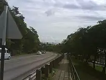
 University Drive
- With St. Thomas: – Starting from the meeting point of the parishes of St. Thomas, St. George, and St. Michael and proceeding along Highway E in a south-westerly direction to the junction with the public road running from Canewood to Jackson; then in a westerly, northerly and north-westerly direction to the junction at Jackson with the public road called Highway 2; then in a south-westerly direction along this road to the centre of the roundabout at its junction at Warrens with the Airport to West Coast Highway; then in a north-westerly direction along this Highway to the centre of the roundabout which is its junction with the public road called Highway 2A; then in a northerly direction along this road to the meeting point of the parishes of St. Thomas, St. James, and St. Michael.[2]
House constituencies
- City of Bridgetown
- Saint Michael-Central
- Saint Michael-East
- Saint Michael-North
- Saint Michael-North East
- Saint Michael-North West
- Saint Michael-South
- Saint Michael-South Central
- Saint Michael-South East
- Saint Michael-West
- Saint Michael-West Central
Places
Found in St. Michael are:
- Caribbean Broadcasting Corporation, Pine
- Caribbean Development Bank, Wildey
- The Sir Gary Sobers Sports complex
- The Kensington Oval
- The National stadium, Waterford
- The Lloyd Erskine Sandiford Centre, Two Mile Hill
- The Black Rock Psychiatric Hospital, commonly called 'Jenkins'
- The Queen Elizabeth Hospital, Barbados' primary health care facility
- State House, formerly Government House, the official residence of the President of Barbados
- Various government offices such as the Ministry of Education and the Ministry of Industry and International Business
Economy
Kayla Foods Int'l (Barbados) Inc., an international division of Yogen Früz, is located in Saint Michael.[3]
Education

Schools located in St. Michael include:
- American University of Barbados[4]
- American University of Integrative Sciences
- Ann Hill School
- Barbados Community College[5]
- Cave Hill Campus of the University of the West Indies
- Cave Hill School of Business[6]
- Charles F. Broome Memorial Primary School
- Combermere School
- Erdiston Primary School and Special Unit
- Erdiston Teachers' Training College
- Graydon Sealy Secondary School
- Harrison College
- Irving Wilson School
- Parkinson Memorial Secondary School
- Ross University School of Medicine
- Samuel Jackman Prescod Polytechnic[7]
- Springer Girls' Memorial Secondary School
- St. Leonard's Boys' Secondary School
- The St. Michael School
Notable people
- Tino Best, cricketer
- Stede Bonnet, land owner turned pirate, known as “The Gentleman Pirate”
- Marsha K. Caddle, politician, economist and Minister of Finance, Economic Affairs and Investment
- London Bourne, former slave who became a wealthy merchant and landowner
- Annalee Davis, Barbadian-born visual artist
- Sir Wes Hall, cricketer and former Minister for Sport & Tourism
- Shai Hope, cricketer
- Elvis Joseph, former National Football League running back, first professional American Football player from Barbados
- John Goddard, cricketer and businessmen
- Anthony Kellman, poet, novelist and musician
- Frank Marshall, Anglican Dean of Barbados, based at the Cathedral Church of Saint Michael and All Angels in Saint Michael
- Velma Scantlebury, first woman African American transplant surgeon in the United States, born in Goodland, St Michael
- Rihanna (Robyn Rihanna Fenty), singer, rapper, songwriter, actress, designer, ambassador, billionaire entrepreneur
- Sir Garfield Sobers, cricketer
- Nellie Weekes (1896–1990) – campaigner for women's rights, who ran for office in 1942, before women were allowed to vote in the country.[8][9]
- Neville Goddard, writer, lecturer, and mystic
References
- iso:code:3166:BB, International Organization for Standardization
- "Barbados, Chapter 108: Parish Boundaries (1986-18)". The Barbados Parliament. 1986-10-16. Retrieved 2023-04-04.
- "Contact Us Archived 2019-07-10 at the Wayback Machine." Yogen Früz. Retrieved on March 15, 2014. "Kayla Foods Int'l (Barbados) Inc. international 27 Pine Road, Belleville St. Michael, Barbados, W.I."
- American University of Barbados, School of Medicine. "Study Medicine | Best Caribbean Medical Schools". American University of Barbados. Retrieved 2022-12-14.
- "Welcome to the Official Website of the Barbados Community College | The Barbados Community College". bcc.edu.bb. Retrieved 31 March 2016.
- "Welcome / Cave Hill School of Business". uwichsb.org. Retrieved 31 March 2016.
- "Samuel Jackman Prescod Institute of Technology". sjpp.edu.bb. Retrieved 31 March 2016.
- Burrowes, Avonda (1982). "Profile: Nellie Weekes—Activist, Organizer and Champion". Woman Speak!. Pinelands, St. Michael, Barbados: University of the West Indies for the Caribbean Women's Association (7): 14–15. LCCN 89649470. OCLC 12795393. Retrieved 6 September 2020.
- Alexander, Robert J.; Parker, Eldon M. (2004). A History of Organized Labor in the English-speaking West Indies. Westport, Connecticut: Praeger Publishing. p. 263. ISBN 978-0-275-97743-6.