Rustic, Colorado
Rustic is an unincorporated community in Larimer County, Colorado, United States. Rustic is located on State Highway 14 and the Cache La Poudre River 27.3 miles (43.9 km) west-northwest of Fort Collins. The community borders Glen Echo to the west.
Rustic, Colorado | |
|---|---|
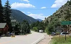 Rustic and Poudre Canyon Road, looking west | |
 Rustic  Rustic | |
| Coordinates: 40°41′57″N 105°34′53″W | |
| Country | United States |
| State | Colorado |
| County | Larimer |
| Elevation | 7,165 ft (2,184 m) |
| Time zone | UTC-7 (Mountain (MST)) |
| • Summer (DST) | UTC-6 (MDT) |
| Area code | 970 |
| GNIS feature ID | 177128[1] |
In 1881, S.B. Stewart built the Rustic Hotel at this location. It soon became a popular summer tourist resort.[2]
The town of Rustic was established in 1882.[3]
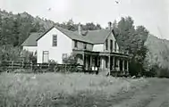 Rustic Hotel, c. 1910
Climate
According to the Köppen Climate Classification system, Rustic has an oceanic climate, abbreviated "Cfb" on climate maps. The hottest temperature recorded in Rustic was 92 °F (33 °C) on July 22, 2005 and June 17, 2021, while the coldest temperature recorded was −27 °F (−33 °C) on March 4, 2019.[4]
| Climate data for Rustic, Colorado, 1991–2020 normals, extremes 1993–present | |||||||||||||
|---|---|---|---|---|---|---|---|---|---|---|---|---|---|
| Month | Jan | Feb | Mar | Apr | May | Jun | Jul | Aug | Sep | Oct | Nov | Dec | Year |
| Record high °F (°C) | 60 (16) |
60 (16) |
70 (21) |
74 (23) |
84 (29) |
92 (33) |
92 (33) |
90 (32) |
90 (32) |
78 (26) |
69 (21) |
64 (18) |
92 (33) |
| Mean maximum °F (°C) | 52.4 (11.3) |
51.7 (10.9) |
61.8 (16.6) |
68.2 (20.1) |
75.5 (24.2) |
84.9 (29.4) |
86.7 (30.4) |
85.4 (29.7) |
81.7 (27.6) |
72.5 (22.5) |
62.5 (16.9) |
53.1 (11.7) |
87.6 (30.9) |
| Average high °F (°C) | 35.7 (2.1) |
36.4 (2.4) |
43.7 (6.5) |
49.3 (9.6) |
59.3 (15.2) |
71.7 (22.1) |
77.9 (25.5) |
76.2 (24.6) |
68.9 (20.5) |
55.8 (13.2) |
43.8 (6.6) |
35.7 (2.1) |
54.5 (12.5) |
| Daily mean °F (°C) | 25.6 (−3.6) |
25.4 (−3.7) |
32.1 (0.1) |
37.0 (2.8) |
45.9 (7.7) |
56.0 (13.3) |
62.7 (17.1) |
61.1 (16.2) |
53.7 (12.1) |
42.5 (5.8) |
32.6 (0.3) |
25.3 (−3.7) |
41.7 (5.4) |
| Average low °F (°C) | 15.4 (−9.2) |
14.5 (−9.7) |
20.4 (−6.4) |
24.8 (−4.0) |
32.4 (0.2) |
40.3 (4.6) |
47.5 (8.6) |
46.1 (7.8) |
38.4 (3.6) |
29.2 (−1.6) |
21.4 (−5.9) |
14.8 (−9.6) |
28.8 (−1.8) |
| Mean minimum °F (°C) | −6.7 (−21.5) |
−8.3 (−22.4) |
1.8 (−16.8) |
10.3 (−12.1) |
19.7 (−6.8) |
32.0 (0.0) |
38.8 (3.8) |
37.6 (3.1) |
27.3 (−2.6) |
13.5 (−10.3) |
3.7 (−15.7) |
−7.0 (−21.7) |
−14.7 (−25.9) |
| Record low °F (°C) | −19 (−28) |
−26 (−32) |
−27 (−33) |
−5 (−21) |
7 (−14) |
26 (−3) |
33 (1) |
34 (1) |
19 (−7) |
−10 (−23) |
−18 (−28) |
−25 (−32) |
−27 (−33) |
| Average precipitation inches (mm) | 0.47 (12) |
0.50 (13) |
0.91 (23) |
1.52 (39) |
1.72 (44) |
1.39 (35) |
1.63 (41) |
1.43 (36) |
1.36 (35) |
1.05 (27) |
0.69 (18) |
0.50 (13) |
13.17 (336) |
| Average snowfall inches (cm) | 6.4 (16) |
7.9 (20) |
13.0 (33) |
15.7 (40) |
5.5 (14) |
0.0 (0.0) |
0.0 (0.0) |
0.0 (0.0) |
1.7 (4.3) |
6.7 (17) |
8.2 (21) |
8.1 (21) |
73.2 (186.3) |
| Average precipitation days (≥ 0.01 in) | 4.3 | 5.4 | 5.7 | 8.1 | 9.7 | 7.2 | 9.9 | 9.9 | 7.9 | 6.3 | 5.1 | 5.4 | 84.9 |
| Average snowy days (≥ 0.1 in) | 3.5 | 4.4 | 4.5 | 5.1 | 1.3 | 0.0 | 0.0 | 0.0 | 0.5 | 2.1 | 3.9 | 4.5 | 29.8 |
| Source 1: NOAA[5] | |||||||||||||
| Source 2: National Weather Service (mean maxima and minima 2006–2020)[4] | |||||||||||||
References
- "Rustic". Geographic Names Information System. United States Geological Survey, United States Department of the Interior.
- Marcus P. Grant; Christian J. Zier & Robert G. Rosenberg (1988). "SUPPLEMENTAL REPORT: CULTURAL RESOURCE INVESTIGATIONS IN STAGE ONE AREAS OF THE BASIN STUDY EXTENSION, CACHE LA POUDRE HYDROELECTRIC PROJECT, LARIMER COUNTY, COLORADO" (PDF). Centennial Archaeology, Inc.
- Bright, William (2004). Colorado Place Names. Johnson Books. ISBN 9781555663339.
- "NOAA Online Weather Data". National Weather Service. Retrieved September 7, 2022.
- "U.S. Climate Normals Quick Access". National Oceanic and Atmospheric Administration. Retrieved September 7, 2022.
External links
Municipalities and communities of Larimer County, Colorado, United States | ||
|---|---|---|
| Cities |  Map of Colorado highlighting Larimer County | |
| Towns | ||
| CDPs | ||
| Unincorporated communities | ||
| Ghost towns | ||
| Footnotes | ‡This populated place also has portions in an adjacent county or counties | |
This article is issued from Wikipedia. The text is licensed under Creative Commons - Attribution - Sharealike. Additional terms may apply for the media files.