Ruby, Louisiana
Ruby is an unincorporated community in Rapides Parish, Louisiana, United States. It is a populated place located within the Parish Governing Authority District C.[2] The community is located on Louisiana Highway 454, 14.3 miles (23.0 km) southeast of Alexandria. Ruby had a post office from April 18, 1900, until October 8, 2011; it still has its own ZIP code, 71365.[3][4] The elevation of Ruby is 98 feet. Rapides Parish is in the Central Time Zone (UTC -6 hours).[5]
Ruby, Louisiana | |
|---|---|
 Ruby, Louisiana  Ruby, Louisiana | |
| Coordinates: 31°11′22″N 92°14′55″W | |
| Country | United States |
| State | Louisiana |
| Parish | Rapides |
| Elevation | 98 ft (30 m) |
| Time zone | UTC-6 (Central (CST)) |
| • Summer (DST) | UTC-5 (CDT) |
| ZIP code | 71365 |
| Area code | 318 |
| GNIS feature ID | 538760[1] |
References
- "Ruby". Geographic Names Information System. United States Geological Survey, United States Department of the Interior.
- "Ruby Populated Place Profile / Rapides Parish, Louisiana Data". louisiana.hometownlocator.com. Retrieved June 14, 2021.
- United States Postal Service. "USPS - Look Up a ZIP Code". Retrieved May 23, 2015.
- "Postmaster Finder - Post Offices by ZIP Code". United States Postal Service. Retrieved May 23, 2015.
- "Ruby Populated Place Profile / Rapides Parish, Louisiana Data". louisiana.hometownlocator.com. Retrieved June 14, 2021.
Municipalities and communities of Rapides Parish, Louisiana, United States | ||
|---|---|---|
| Cities | 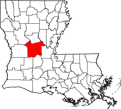 | |
| Towns | ||
| Villages | ||
| CDPs | ||
| Other communities | ||
This article is issued from Wikipedia. The text is licensed under Creative Commons - Attribution - Sharealike. Additional terms may apply for the media files.