Rosis
Rosis is a commune in the Hérault department in the Occitanie region in southern France.
Rosis | |
|---|---|
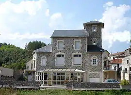 The town hall of Rosis | |
.svg.png.webp) Coat of arms | |
Location of Rosis | |
 Rosis  Rosis | |
| Coordinates: 43°40′04″N 3°00′17″E | |
| Country | France |
| Region | Occitania |
| Department | Hérault |
| Arrondissement | Béziers |
| Canton | Saint-Pons-de-Thomières |
| Intercommunality | Monts de Lacaune et Montagne du Haut Languedoc |
| Government | |
| • Mayor (2020–2026) | Anne-Lise Sauterel[1] |
| Area 1 | 52.91 km2 (20.43 sq mi) |
| Population | 269 |
| • Density | 5.1/km2 (13/sq mi) |
| Time zone | UTC+01:00 (CET) |
| • Summer (DST) | UTC+02:00 (CEST) |
| INSEE/Postal code | 34235 /34610 |
| Elevation | 272–1,123 m (892–3,684 ft) (avg. 380 m or 1,250 ft) |
| 1 French Land Register data, which excludes lakes, ponds, glaciers > 1 km2 (0.386 sq mi or 247 acres) and river estuaries. | |
Population
| Year | Pop. | ±% |
|---|---|---|
| 1962 | 261 | — |
| 1968 | 343 | +31.4% |
| 1975 | 269 | −21.6% |
| 1982 | 244 | −9.3% |
| 1990 | 257 | +5.3% |
| 1999 | 261 | +1.6% |
| 2008 | 304 | +16.5% |

The hamlet of Douch, commune of Rosis
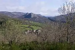
The hamlet of Douch, commune of Rosis
See also
References
- "Répertoire national des élus: les maires". data.gouv.fr, Plateforme ouverte des données publiques françaises (in French). 9 August 2021.
- "Populations légales 2020". The National Institute of Statistics and Economic Studies. 29 December 2022.
Wikimedia Commons has media related to Rosis.
This article is issued from Wikipedia. The text is licensed under Creative Commons - Attribution - Sharealike. Additional terms may apply for the media files.