Roppeviller
Roppeviller (French pronunciation: [ʁɔpvilɛʁ]; German: Roppweiler; Lorraine Franconian: Roppwiller) is a commune in the Moselle department of the Grand Est administrative region in north-eastern France.
Roppeviller | |
|---|---|
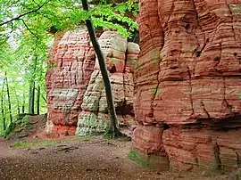 The Altschloss | |
 Coat of arms | |
Location of Roppeviller | |
 Roppeviller 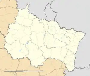 Roppeviller | |
| Coordinates: 49°06′10″N 7°30′34″E | |
| Country | France |
| Region | Grand Est |
| Department | Moselle |
| Arrondissement | Sarreguemines |
| Canton | Bitche |
| Intercommunality | CC du Pays de Bitche |
| Government | |
| • Mayor (2020–2026) | Serge Stebler[1] |
| Area 1 | 13.77 km2 (5.32 sq mi) |
| Population | 98 |
| • Density | 7.1/km2 (18/sq mi) |
| Time zone | UTC+01:00 (CET) |
| • Summer (DST) | UTC+02:00 (CEST) |
| INSEE/Postal code | 57594 /57230 |
| Elevation | 257–451 m (843–1,480 ft) (avg. 260 m or 850 ft) |
| 1 French Land Register data, which excludes lakes, ponds, glaciers > 1 km2 (0.386 sq mi or 247 acres) and river estuaries. | |
The village belongs to the Pays de Bitche and to the Northern Vosges Regional Nature Park.
A path from the village runs up to the Altschlossfelsen rocks, a popular walking destination, on the hill of Brechenberg on the German side of the border.
See also
References
- "Répertoire national des élus: les maires". data.gouv.fr, Plateforme ouverte des données publiques françaises (in French). 2 December 2020.
- "Populations légales 2020". The National Institute of Statistics and Economic Studies. 29 December 2022.
External links
 Media related to Roppeviller at Wikimedia Commons
This article is issued from Wikipedia. The text is licensed under Creative Commons - Attribution - Sharealike. Additional terms may apply for the media files.