Rockton Mountain Trails
The Rockton Mountain Trails are an approximately 17.1-mile (27.5 km) network of connected hiking trails in central Pennsylvania, in Moshannon State Forest.[1] The total trail distance includes several different linear trails that can be used to form one-way and loop hikes of various lengths. The trail system is also often used for cross-country skiing, with some segments available for mountain biking as well.[2]
| Rockton Mountain Trails | |
|---|---|
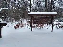
 The trailhead for the Rockton Mountain Trails system | |
| Length | 17.1 mi (27.5 km) |
| Location | Clearfield County, Pennsylvania, US |
| Use | Hiking, cross-country skiing, mountain biking |
| Elevation change | Moderate |
| Difficulty | Moderate |
| Season | Year-round; hiking and biking discouraged during winter months |
| Hazards | Uneven and rocky terrain, rattlesnakes, mosquitoes, ticks, black bears |
Description
The Rockton Mountain Trails were constructed starting in 1993, with a volunteer named Ben Irwin leading the efforts. Trails were built to reach scenic areas along Panther Run, Horn Shanty Stream, and Coupler Run.[2] The area was selected for its heavy snowfall in order to attract cross-country skiers during the winter, though other users are welcomed during non-winter months.[2] The trailhead is found on US Route 322, about three miles west of its northern interchange with Pennsylvania Route 153, or about four miles east of the village of Rockton.[3]
References
- Pennsylvania Department of Conservation and Natural Resources, Rockton Mountain Trails: Moshannon State Forest, 2000.
- Seeley, Ralph (2014). Foot Trails of the Moshannon and Southern Elk State Forests. Spring Mills, PA: Scott Adams Enterprises. p. 100. ISBN 9780985193973.
- Cramer, Ben, ed. (2008). Pennsylvania Hiking Trails (13th ed.). Mechanicsburg, Pennsylvania: Stackpole Books. p. 147-148. ISBN 9780811734776.